Gevaş
Gevaş (Armenian: Ոստան, romanized: Vostan, lit. '[princely] court',[2] Kurdish: Westan[3]) is a municipality and district of Van Province, Turkey.[4] Its area is 1,544 km2,[5] and its population is 26,918 (2022).[1] In the last elections of March 2019, Murat Sezer from the Justice and Development Party (AKP) was elected Mayor.[6] As Kaymakam, Hamit Genç was appointed by President Recep Tayyip Erdoĝan in July 2019.[7]
Gevaş
Vostan • Ոստան | |
|---|---|
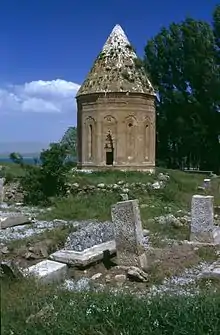
 Gevaş tomb | |
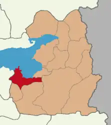
 Map showing Gevaş District in Van Province | |
 Gevaş Location in Turkey | |
| Coordinates: 38°17′52″N 43°06′20″E | |
| Country | Turkey |
| Province | Van |
| Government | |
| • Mayor | Murat Sezer (AKP) |
| Area | 1,544 km2 (596 sq mi) |
| Population (2022)[1] | 26,918 |
| • Density | 17/km2 (45/sq mi) |
| Time zone | TRT (UTC+3) |
| Postal code | 65700 |
| Area code | 0432 |
| Website | www |
History
Historically, Gevaş was for some time the main town of the Armenian kingdom of Vaspurakan and later between the 14th and 15th centuries the centre of a small Kurdish emirate. In their time the settlement had moved nearer to the lake.[2] Later the town was incorporated in the Ottoman Empire. Before World War I, the district had a Muslim majority with a large Christian Armenian minority.
Main sights include surviving ruins of the castle, the monumental tomb known as Halime Hatun Kümbeti, built in 1358, very likely for the daughter of a local emir,[2] a mosque built before 1446 (restoration in that year), the tomb of Sheikh Ibrahim, father of Halime Hatun[2] as well as the ruins of an Armenian church in Ili, probably built after 941 and an Armenian Church/monastery on Kuşadası Island west of Aghtamar Island.[2]
Composition
There are 42 neighbourhoods in Gevaş District:[8]
- Abalı
- Akdamar
- Aladüz
- Altınsaç
- Anaköy
- Atalan
- Aydınocak
- Bağlama
- Bahçelievler
- Barışık
- Dağyöre
- Daldere
- Değirmitaş
- Dereağzı
- Dilmetaş
- Dokuzağaç
- Elmalı
- Göründü
- Gündoğan
- Güzelkonak
- Hasbey
- Hişet
- İkizler
- İnköy
- Karşıyaka
- Kayalar
- Kazanç
- Kızıltaş
- Koçak
- Kurultu
- Kuşluk
- Orta
- Pınarbaşı
- Selimiye
- Timar
- Töreli
- Uğurveren
- Uysal
- Yanıkçay
- Yemişlik
- Yoldöndü
- Yuva
References
- "Address-based population registration system (ADNKS) results dated 31 December 2022, Favorite Reports" (XLS). TÜİK. Retrieved 19 September 2023.
- Sinclair, T.A. (1989). Eastern Turkey: An Architectural & Archaeological Survey, Volume I. Pindar Press. pp. 222–223. ISBN 9780907132325.
- Mendeş, Hurşit Baran (2022). Ertoşîler (in Turkish). Doz. p. 342.
- Büyükşehir İlçe Belediyesi, Turkey Civil Administration Departments Inventory. Retrieved 19 September 2023.
- "İl ve İlçe Yüz ölçümleri". General Directorate of Mapping. Retrieved 19 September 2023.
- "Van Gevaş Seçim Sonuçları - 31 Mart 2019 Yerel Seçimleri". www.sabah.com.tr. Retrieved 2020-04-21.
- "KAYMAKAMIMIZ". www.gevas.gov.tr. Retrieved 2020-04-21.
- Mahalle, Turkey Civil Administration Departments Inventory. Retrieved 19 September 2023.
