Ghotki District
Ghotki District (Sindhi: ضِلعو گھوٽڪي; Urdu: ضلع گھوٹکی) is a district of the province of Sindh, Pakistan, with headquarter the city of Mirpur Mathelo. Prior to its establishment as a district in 1993, it formed part of Sukkur District.[2]
Ghotki District
ضِلعو گھوٽڪي | |
|---|---|
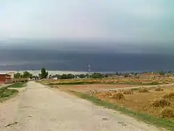 Wango village | |
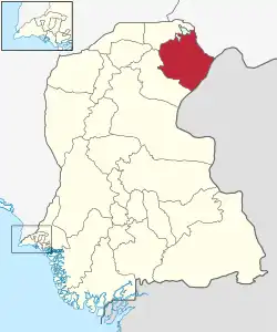 Location of Ghotki in Sindh province | |
| Coordinates: 27°49′N 69°39′E | |
| Country | |
| Province | |
| Division | Sukkur |
| District | 1983 |
| Headquarters | Mirpur Mathelo |
| Government | |
| • Type | District Administration |
| • Deputy Commissioner | N/A |
| • District Police Officer | N/A |
| • District Health Officer | N/A |
| Area | |
| • Total | 6,083 km2 (2,349 sq mi) |
| Population (2017)[1] | |
| • Total | 1,647,239 |
| • Density | 270/km2 (700/sq mi) |
| Time zone | UTC+5 (PST) |
| Website | www |
Geography
Ghotki District is stretched in 6975 km2 (1,555,528 acres). 25,000 acres area of the district consisting of desert land, 402,578 acres (25.88%) is flooded (Katcha) area and remaining area lying between desert and flooded areas of district is cultivated. Desert area having wind-blown hills as Achro Thar (White Desert). Flooded area (Kacha) is stretched on 87 km along Indus River from north - east to south - west of the district where forests exist in this area.
Administration
The Ghotki district is administratively subdivided into the following Tehsils:
- Mirpur Mathelo Tehsil[3]
- Daharki Tehsil
- Ghotki Tehsil[3]
- Ubauro Tehsil
- Khangarh Tehsil[3]
Demographics
| Year | Pop. | ±% p.a. |
|---|---|---|
| 1951 | 179,186 | — |
| 1961 | 221,243 | +2.13% |
| 1972 | 401,318 | +5.56% |
| 1981 | 558,058 | +3.73% |
| 1998 | 968,490 | +3.30% |
| 2017 | 1,648,708 | +2.84% |
| source: | ||
At the time of the 2017 census, Ghotki district had a population of 1,648,708, of which 360,821 (21.89%) lived in urban areas. Ghotki had a sex ratio of 939 females per 1000 males and a literacy rate of 40.88%: 57.46% for males and 23.35% for females.[1]
| Religion | Population (1941)[4]: 54–57 | Percentage (1941) | Population (2017) | Percentage (2017) |
|---|---|---|---|---|
| Islam |
139,222 | 82.21% | 1,544,355 | 93.67% |
| Hinduism |
29,850 | 17.63% | 101,974 | 6.19% |
| Others [lower-alpha 2] | 284 | 0.17% | 2,379 | 0.14% |
| Total Population | 169,356 | 100% | 1,648,708 | 100% |
The majority religion is Islam, with 93.67% of the population. Hinduism (including those from Scheduled Castes) is practiced by 6.19% of the population.
At the time of the 2017 census, 93.37% of the population spoke Sindhi, 2.49% Urdu, 1.64% Punjabi and 1.05% Saraiki as their first language.
The historic Hindu temple Shadani Darbar is located in this district.[5]
List of Dehs
The following is a list of Dadu District's 351 dehs, organised by taluka:[6]
- Ghotki Taluka (77 dehs)
- Adilpur
- Amirabad
- Attal Muradani
- Bago Daho
- Bandh
- Baqro
- Behishti
- Belo Gublo
- Belo Jamshero
- Belo Sangri
- Beriri
- Bhanjro
- Bhiryalo
- Bhityoon
- Changlani
- Dari
- Dhamaji
- Doomano
- Drago
- Dring Chachhar
- Erazi
- Esa Wali
- Fazal Bhayo
- Hakra
- Hamro
- Hussain Beli
- Jahanpur
- Jamal
- Janghiari
- Katcho Bahab
- Katcho Bindi
- Katcho Miranpur
- Katcho Tibi
- Katco Buxo Ghoto
- Khadwari
- Khahi Daro
- Kham
- Khuhara
- Azmat Khan Bharo
- Kotlo Bullo
- Labana
- Lakhan
- Laloowali
- Maka
- Malhir
- Malook Wali
- Mathelo
- Miyani
- Moto Mahar
- Muhammad Pur
- Odharwali
- Pacco Bahab
- Pacco Bindi
- Pacco Buxo Ghoto
- Pacco Miranpur
- Pacco Tibi
- Pano Khalso
- Phekrato
- Qadirpur
- Qaloo Malhan
- Qazi Wahan
- Ruk
- Salehn Malhar
- Sangi Ghotki
- Sangri
- Sarhad
- Satabo Bhayo
- Shafiabad
- Shaikhani
- Suhriani
- Sundrani
- Thatho Malhan
- Vidhur
- Wad Pagiya
- Wagni
- Wasayo Chachar
- Wasti Inayat Shah
- Wasti Q. Din Shah
- Daharki Taluka (48 dehs)
- Alamarain
- Bago Daro
- Belo Berutta
- Berutta
- Chacharki
- Chanad
- Chhoranwalo
- Daharki
- Derawaro
- Dhandh Raharki
- Goi
- Gorhelo
- Gulo Pitafi
- Hamidpur
- Hiko
- Ibrahim Pitafi
- Jado Pitafi
- Jampur
- Jhanwar
- Jhum
- Jung
- Bharo
- Kalwar
- Katta
- Khenjho
- Kherohi
- Khushkh
- Kotlo
- Lal Pitafi
- Looni
- Maringaro
- Mirzapur
- Poh No1
- Poh No2
- Raharki
- Rail
- Raini
- Sain Dino Malik
- Sanilo
- Sanko
- Sejan
- Shahbazpur
- Simno
- Sutiayaro No5
- Sutiyaro Chak No1
- Sutiyaro Chak No2
- Takio M. Pannah
- Vijnoth
- Wahi Gul Khan
- Khan Garh Taluka (37 dehs)
- Aithi
- Ali Mahar
- Ari Mahar
- Bambli
- Bandwari
- Bari
- Bhetoor
- Bhitoin
- Chak Qazi Badal
- Chhanwani
- Dakhano
- Ibrahim Mahar
- Izat Wari
- Kandlo
- Khabar Chachar
- Khangarh
- Khanpur
- Lakho Mahar
- Lohi
- Makahi
- Mithri
- Naro
- Pathan Mahar
- Phul Daho
- Qazi Badal
- Raanyar
- Sahta
- Samo Wah
- Sanharo
- Shahpur
- Sutiaro No. 1
- Sutiaro No. 3
- Tarai
- Wahi Dhano
- Waloo Mahar
- Walrah
- Warwaro
- Mirpur Matelo Taluka (60 dehs)
- Akhtiar Waseer
- Alim Khan Gadani
- Baloch Khan
- Barar
- Bel Mirpur
- Belo Waseer
- Belo Bozdar
- Bhiri Laghari
- Chijjan
- Damanon
- Darwesh Naich
- Dhangro
- Dil Muard Gabole
- Dino Mako
- Drib Dethri
- Fatehpur
- Gahno lund
- Gaji Gadani
- Garhi Chakar
- Gendarko
- Gurkan
- Haj Korai
- Hamind Korai
- Hayat Pitafi
- Ismail Bozdar
- Jahan Khan Unar
- Jarwar
- Jhangan
- Jindo Pitafi
- Kander
- Karampur
- Khansar
- Khu Meenhon
- Khui Khengi
- Lashkri Lund
- Latif Shah
- Machalo
- Malnas
- Meroja
- Mirpur
- Mitho Lund
- Nhundri
- Pipri
- Sabar Bozdar
- Saeed Khan Chandio
- Sahib Khan Lund
- Shekhan Wari
- Sher Ali Gabole
- Sher Khan Bozdar
- Sher Khan Kolachi
- Sobho Lund
- Sono Pitafi
- Suhanjro
- Sutyaro 1
- Sutyaro 4
- Tahir Gadani
- Wah Bakro
- Wadhi Ghoto
- Wahi Mubarak
- Yaro Lund
- Ubauro Taluka
- B. Rano Rahar
- Band
- Bapar
- Belo Rawanti
- Bindi adam
- Bindo A. Sattar
- Bori
- Chanali
- Chandia
- Chatu Daho
- Dabli
- Daulatpur
- Daveri
- Detha Bhaya
- Dilwaro
- Dub
- Garang
- Ghundi
- Girkno
- Gohram chachar
- Goongo daho
- Islam Lashari
- Jhangal Dawo
- Jhangal malik
- Kalwli
- Kamo Shaheed
- Katcho miani malook
- Keenjhar
- Khambhra
- Khamiso Chachar
- Koraiki
- Kotlo kamil
- Kotlo Yousuf
- Kubhur
- Kundri Walo
- Mari
- Maroowalo
- Matar Kot
- Muhammad Pur
- Muradpur
- Naseer dhandu
- Nurley
- Pako miani malook
- Pir Bux
- Rajanpur
- Rano Rahar
- Rawanti
- Reti
- Rind
- Sayed Pur
- Shadi walo
- Shahwali
- Shams chapri
- Shewani
- Soi Sharef
- Sonan
- Tig
- Ubauro
- W. J. Shah
- Warwalo
Economy
Ghotki District has recently embraced sugar cane. The total acreage of cultivable land is 286,090 ha in 2019–20. The area under cultivation of sugar cane increased to 58,774 ha in 2019-20 from 6,511 ha in 2011–12. Five functional sugar mills are located in the district.[7]
Culture
Ghotki District is the land of Saint where is many Saint's Tomb. 1- Syed Anwar shah at Jahnpur 2- Syed Jaleel Shah Mast 5 kilometres away from Mipur Mathelo town 3- Nare shah Jelani In Ghotki Town. Ghotki District has many historical places, one of them is Mathelo Moomal Ji Mari, there is a museum and at the same place very popular saint Syed Nathan shah's (Naharo) Tomb.
See also
Notes
- Ghotki, Mirpur Bathoro and Ubauro taluks of Sukkur district
- Including Jainism, Christianity, Buddhism, Zoroastrianism, Judaism, Ad-Dharmis, or not stated
References
- "Ghotki District, Sindh population per 2017 census". Citypopulation.de website. Archived from the original on 22 June 2020. Retrieved 21 April 2023.
- PCO 1998, p. 10.
- "Zila (District), Tehsil & Town Councils Membership for Sindh (Ghotki District)". Election Commission of Pakistan, Government of Pakistan website. Archived from the original on 5 March 2009. Retrieved 21 April 2023.
- "CENSUS OF INDIA, 1941 VOLUME XII SINDH PROVINCE".
- "Hindu pilgrims attend central ceremony of Shadani Darbar". Pakistan Today. 6 December 2018. Retrieved 23 December 2020.
- "List of Dehs in Sindh" (PDF). Sindh Zameen. Retrieved 22 March 2021.
- Khan, Mohammad Hussain (2020-11-30). "Ghotki's story of sugar and cotton". DAWN.COM. Retrieved 2020-12-29.
Bibliography
- 1998 District census report of Ghotki. Census publication. Vol. 88. Islamabad: Population Census Organization, Statistics Division, Government of Pakistan. 2000.