Goyave
Goyave (French pronunciation: [ɡwajav], unlike goyave [ɡɔjav]; Guadeloupean Creole: Gwayav) is a commune in the French overseas region and department of Guadeloupe, Lesser Antilles. It is part of the urban area of Pointe-à-Pitre, the largest metropolitan area in Guadeloupe.
Goyave | |
|---|---|
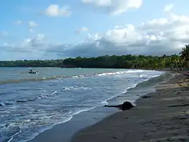
 Sainte-Claire Beach to the south of Goyave | |
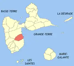
 Location of the commune (in red) within Guadeloupe | |
Location of Goyave | |
| Coordinates: 16°08′N 61°34′W | |
| Country | France |
| Overseas region and department | Guadeloupe |
| Arrondissement | Basse-Terre |
| Canton | Petit-Bourg |
| Intercommunality | CA Nord Basse-Terre |
| Government | |
| • Mayor (2020–2026) | Ferdy Louisy[1] |
| Area 1 | 59.91 km2 (23.13 sq mi) |
| Population | 7,635 |
| • Density | 130/km2 (330/sq mi) |
| Time zone | UTC−04:00 (AST) |
| INSEE/Postal code | 97114 /97128 |
| 1 French Land Register data, which excludes lakes, ponds, glaciers > 1 km2 (0.386 sq mi or 247 acres) and river estuaries. | |
History
The parish of Goyave was founded in 1684 under the name of “Sainte-Anne de la petite rivière à Goyave” (Saint Anne of the little river at Guava). Guavas that grow abundantly beside the rivers in this area led the town to adopt its name. Slave labor was commonly used here, when slavery was legal in France, and there were many public executions of rebel slaves here.
Geography
Goyave is located on the eastern part of Basse-Terre Island and the southern section of Goyave is near the Goyave River. Goyave is near Pointe de la Riviere a Goyave and Goyave stretches out along the coast of Petit Cul de Sac Marin. Goyave is on very fertile soil.
Population
| Year | Pop. | ±% p.a. |
|---|---|---|
| 1967 | 3,120 | — |
| 1974 | 2,588 | −2.64% |
| 1982 | 2,919 | +1.52% |
| 1990 | 3,652 | +2.84% |
| 1999 | 5,060 | +3.69% |
| 2007 | 7,661 | +5.32% |
| 2012 | 8,079 | +1.07% |
| 2017 | 7,555 | −1.33% |
| Source: INSEE[3] | ||
Economy
The commune gets its name from the large numbers of guava trees (goyave is the French for guava), which run alongside the river flowing from the mountain. In agriculture, the sugar cane culture has been replaced by bananas and by aquaculture.
Sights
- The Moreau Falls
- The water garden in Blonzac
- The Dull One in Louis
- The Sand Handle
- Ilet Fortune
- The beach of Holy Claire
- The Orchard of 1000 Fruits
- The village O Ti Bouboul (including the agritouristic site, the “magic forest of Moreau”)
Education
Public preschools and primary schools include:[4]
- Ecole primaire François Auguste
- Ecole primaire Christophe
- Ecole maternelle Bourg Goyave
Public junior high schools include:[5]
- Collège Matéliane
References
- "Répertoire national des élus: les maires" (in French). data.gouv.fr, Plateforme ouverte des données publiques françaises. 13 September 2022.
- "Populations légales 2020". The National Institute of Statistics and Economic Studies. 29 December 2022.
- Population en historique depuis 1968, INSEE
- "LISTE DES ECOLES PUBLIQUES ET PRIVEES SOUS CONTRAT." Académie de la Guadeloupe. Retrieved on 10 March 2018.
- "Établissements du 2nd degré PUBLIC 2017-2018 Archived 2018-03-07 at the Wayback Machine." Académie de la Guadeloupe. Retrieved on 10 March 2018.