Municipal District of Taber
The Municipal District of Taber is a municipal district (MD) in southern Alberta, Canada. It is located in Census Division 2.
Municipal District of Taber | |
|---|---|
|
Logo | |
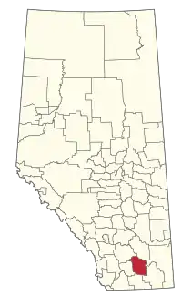 Location within Alberta | |
| Country | Canada |
| Province | Alberta |
| Region | Southern Alberta |
| Census division | 2 |
| Established | 1954 |
| Incorporated | 1954 |
| Government | |
| • Reeve | Merrill Harris |
| • Governing body | MD of Taber Council |
| • Administrative office | Taber |
| Area (2021)[2] | |
| • Land | 4,160.47 km2 (1,606.37 sq mi) |
| Population (2021)[2] | |
| • Total | 7,447 |
| • Density | 1.8/km2 (5/sq mi) |
| • Municipal census (2016) | 7,173[3] |
| Time zone | UTC−7 (MST) |
| • Summer (DST) | UTC−6 (MDT) |
| Website | mdtaber.ab.ca |
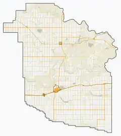
Geography
Communities and localities
|
The following urban municipalities are surrounded by the MD of Taber.[4]
The following hamlets are located within the MD of Taber.[4] |
The following localities are located within the MD of Taber.[5]
|
Demographics
In the 2021 Census of Population conducted by Statistics Canada, the MD of Taber had a population of 7,447 living in 1,971 of its 2,119 total private dwellings, a change of 4.9% from its 2016 population of 7,098. With a land area of 4,160.47 km2 (1,606.37 sq mi), it had a population density of 1.8/km2 (4.6/sq mi) in 2021.[2]
In the 2016 Census of Population conducted by Statistics Canada, the MD of Taber had a population of 7,098 living in 1,857 of its 2,081 total private dwellings, a 3.6% change from its 2011 population of 6,851. With a land area of 4,201.65 km2 (1,622.27 sq mi), it had a population density of 1.7/km2 (4.4/sq mi) in 2016.[6]
The population of the MD of Taber according to its 2016 municipal census is 7,173,[3] a 0.8% change from its 2013 municipal census population of 7,116.[7] By its five hamlets, the 2016 municipal census population breaks down into 259 residents in Enchant, 815 in Grassy Lake, 163 in Hays, 130 in Johnson's Addition and 44 in Purple Springs, resulting in a remaining rural area population of 5,762.[8]
References
- "Municipal Officials Search". Alberta Municipal Affairs. May 9, 2019. Retrieved October 1, 2021.
- "Population and dwelling counts: Canada, provinces and territories, and census subdivisions (municipalities)". Statistics Canada. February 9, 2022. Retrieved February 9, 2022.
- "2016 Municipal Affairs Population List" (PDF). Alberta Municipal Affairs. ISBN 978-1-4601-3127-5. Archived from the original (PDF) on January 16, 2017. Retrieved January 28, 2017.
- "Specialized and Rural Municipalities and Their Communities" (PDF). Alberta Municipal Affairs. January 12, 2022. Retrieved January 21, 2022.
- "Standard Geographical Classification (SGC) 2006, Economic Regions: 4802021 - Taber, geographical codes and localities, 2006". Statistics Canada. March 5, 2010. Retrieved August 12, 2012.
- "Population and dwelling counts, for Canada, provinces and territories, and census subdivisions (municipalities), 2016 and 2011 censuses – 100% data (Alberta)". Statistics Canada. February 8, 2017. Retrieved February 8, 2017.
- "2015 Municipal Affairs Population List" (PDF). Alberta Municipal Affairs. ISBN 978-1-4601-2630-1. Retrieved January 28, 2017.
- "MD Connection (newsletter): 2016 Municipal Census is Complete!". Municipal District of Taber. Summer 2016. p. 6. Retrieved July 14, 2016.
External links
Places adjacent to Municipal District of Taber | |
|---|---|