Guloykhi
Guloykhi, or Guloy-khi (Ingush: ГӀулой-Хий, romanized: Ghuloy-Khiy) is a river in the Dzheyrakhsky District of the Republic of Ingushetia, a right tributary of the Assa River.[1][2]
| Guloykhi | |
|---|---|
.jpg.webp) Guloykhi valley | |
  | |
| Native name | ГӀулой-хи (Ingush) |
| Location | |
| Country | Russian Federation |
| Region | Caucasus |
| Federal subject | Ingushetia |
| Physical characteristics | |
| Source | |
| • coordinates | 42°48′48″N 45°11′23″E |
| Mouth | Assa River |
• location | 103 km on the right bank |
• coordinates | 42°48′20″N 44°56′09″E |
• elevation | 1,112 m (3,648 ft) |
| Length | 24 km |
| Basin size | 161 km2 (62 sq mi) |
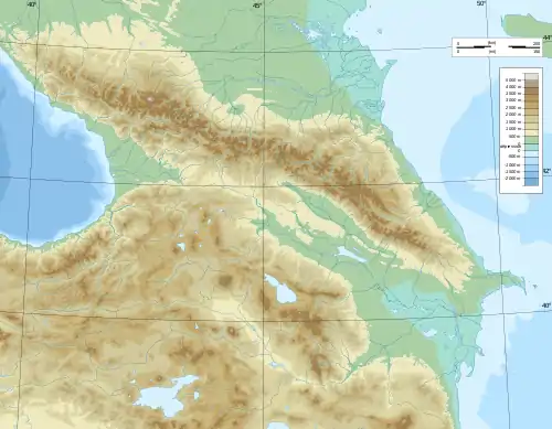
Geography
The Guloykhi river originates in the eastern part of mountainous Ingushetia. It flows west along a mountain valley near several medieval tower settlements, most notably Gul, Läzhg, Qoyrakh, Abali, Vovnushki, Koki, and flows into the Assa near Puy and Tkhaba-Yerdy.[3] A forest mainly covers the left bank of the river.[4] The speed of the flow is 2.2 m/s. The mouth of the river is located 103 km along the right bank of the Assa at an altitude of 1112 meters above sea level.
References
- Volkova 1974, p. 143.
- Reestr zaregistrirovannykh v AGKGN geograficheskikh nazvaniy ob'ektov na 17.12.2021: Republika Ingushetia, p. 5.
- Проект «Открытый Кавказ». "Карта" (in Russian).
- "Долина Гулойхи". skfo.ru. Archived from the original on 22 December 2019. Retrieved 4 December 2013.
Bibliography
- "Реестр зарегистрированных в АГКГН географических названий объектов на 17.12.2021: Республика Ингушетия" [Register of registered in AGKGN geographical names of objects as of 12/17/2021: Republic of Ingushetia] (in Russian).
- Volkova, N. G. (1974). Gardanov, V. K. (ed.). Этнический состав населения Северного Кавказа в XVIII — начале XX века [Ethnic composition of the population of the North Caucasus in the 18th – early 20th centuries] (in Russian). Moskva: Nauka. pp. 1–276.}}
External links
This article is issued from Wikipedia. The text is licensed under Creative Commons - Attribution - Sharealike. Additional terms may apply for the media files.