Hå
Hå is a municipality in Rogaland county, Norway. It is the southernmost municipality in the traditional district of Jæren. The administrative centre of the municipality is the village of Varhaug. Other villages in Hå include Brusand, Hæen, Nærbø, Obrestad, Ogna, Sirevåg, and Vigrestad.
Hå kommune
Haa herred (historic) | |
|---|---|
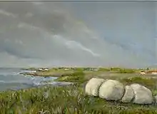
 View of the Brusandstrand beach in Hå | |
 Flag  Rogaland within Norway | |
 Hå within Rogaland | |
| Coordinates: 58°36′23″N 05°43′29″E | |
| Country | Norway |
| County | Rogaland |
| District | Jæren |
| Established | 1 Jan 1838 |
| • Created as | Formannskapsdistrikt |
| Disestablished | 1 Jan 1894 |
| • Succeeded by | Nærbø and Varhaug municipalities |
| Re-established | 1 Jan 1964 |
| • Preceded by | Nærbø, Varhaug, and Ogna municipalities |
| Administrative centre | Varhaug |
| Government | |
| • Mayor (2019) | Jonas Skrettingland (KrF) |
| Area | |
| • Total | 258.00 km2 (99.61 sq mi) |
| • Land | 247.83 km2 (95.69 sq mi) |
| • Water | 10.17 km2 (3.93 sq mi) 3.9% |
| • Rank | #281 in Norway |
| Population (2022) | |
| • Total | 19,296 |
| • Rank | #67 in Norway |
| • Density | 77.9/km2 (202/sq mi) |
| • Change (10 years) | |
| Demonym | Håbu[1] |
| Official language | |
| • Norwegian form | Neutral |
| Time zone | UTC+01:00 (CET) |
| • Summer (DST) | UTC+02:00 (CEST) |
| ISO 3166 code | NO-1119 |
| Website | Official website |

The 258-square-kilometre (100 sq mi) municipality is the 281st largest by area out of the 356 municipalities in Norway. Hå is the 67th most populous municipality in Norway with a population of 19,296. The municipality's population density is 77.9 inhabitants per square kilometre (202/sq mi) and its population has increased by 11.9% over the previous 10-year period.[3][4]
General information
The parish of Haa was established as a municipality on 1 January 1838 (see formannskapsdistrikt law). In 1894, the municipality of Haa was dissolved and divided into two new municipalities: Nærbø (population: 1,806) and Varhaug (population: 1,801). During the 1960s, there were many municipal mergers across Norway due to the work of the Schei Committee. On 1 January 1964, the municipality of Hå was recreated by merging of the neighboring municipalities of Nærbø (population: 3,926), Varhaug (population: 3,454), and Ogna (population: 1,470).[5] In local politics, the divisions between the three previous municipalities remain very visible.
Name
The municipality (originally the parish) is named after the old Hå farm (Old Norse: Háar or Háir) where the local church priest's parsonage was located. The river running past this farm is similarly named the Hååna, meaning the "Hå river". It is not known if the river is named after the farm or vice versa. The meaning of the original name is uncertain. It is possible that it comes from the plural dative case of the word há which means "aftergrass" (the grass that grows after the first crop has been cut down). Ti may also come from the word hár which means "rowlock" (possibly referring to the shape of the headland on which the farm is located). Prior to the 1917 Norwegian language reform law, the name was spelled Haa with the digraph "aa", and after this reform, the letter å was used instead.[6]
Coat of arms
The coat of arms was granted on 5 July 1991. The official blazon is "Sable, a winch stand argent." (Norwegian: På svart grunn eit sølv vinsjestativ). This means the arms have a black field (background) and the charge is a winch stand. The winch stand has a tincture of argent which means it is commonly colored white, but if it is made out of metal, then silver is used. It is a special type of winch that has historically been used in this area to remove stones from the many farm fields. The arms were chosen to symbolize the hard living on the rocky soils of the municipality. A winch of this type (called a "steinbukk") is used locally for the removal of large stones from the soil for agricultural purposes. It's three legs also represent the three previous municipalities of Nærbø, Varhaug, and Ogna that were merged to creat Hå in 1964. The municipal flag has the same design as the coat of arms.[7][8][9]
Churches
The Church of Norway has three parishes (sokn) within the municipality of Hå. It is part of the Jæren prosti (deanery) in the Diocese of Stavanger.
| Parish (sokn) | Church name | Location of the church | Year built |
|---|---|---|---|
| Nærbø | Nærbø Church | Nærbø | 2005 |
| Old Nærbø Church | Nærbø | 1834 | |
| Ogna | Ogna Church | Ogna | 1250 |
| Varhaug | Varhaug Church | Varhaug | 1904 |
Government
All municipalities in Norway are responsible for primary education (through 10th grade), outpatient health services, senior citizen services, welfare and other social services, zoning, economic development, and municipal roads and utilities. The municipality is governed by a municipal council of directly elected representatives. The mayor is indirectly elected by a vote of the municipal council.[10] The municipality is under the jurisdiction of the Sør-Rogaland District Court and the Gulating Court of Appeal.
Municipal council
The municipal council (Kommunestyre) of Hå is made up of 33 representatives that are elected to four year terms. Currently, the party breakdown is as follows:
| Party Name (in Norwegian) | Number of representatives | |
|---|---|---|
| Labour Party (Arbeiderpartiet) | 3 | |
| Progress Party (Fremskrittspartiet) | 3 | |
| Conservative Party (Høyre) | 5 | |
| Christian Democratic Party (Kristelig Folkeparti) | 7 | |
| Centre Party (Senterpartiet) | 5 | |
| Socialist Left Party (Sosialistisk Venstreparti) | 1 | |
| Hå List (Hå-lista) | 9 | |
| Total number of members: | 33 | |
| Party Name (in Norwegian) | Number of representatives | |
|---|---|---|
| Labour Party (Arbeiderpartiet) | 3 | |
| Progress Party (Fremskrittspartiet) | 3 | |
| Conservative Party (Høyre) | 6 | |
| Christian Democratic Party (Kristelig Folkeparti) | 7 | |
| Centre Party (Senterpartiet) | 3 | |
| Nærbø List (Nærbølista) | 10 | |
| Common list for southern Hå (Samlingsliste for søre Hå) | 1 | |
| Total number of members: | 33 | |
| Party Name (in Norwegian) | Number of representatives | |
|---|---|---|
| Labour Party (Arbeiderpartiet) | 3 | |
| Progress Party (Fremskrittspartiet) | 3 | |
| Conservative Party (Høyre) | 7 | |
| Christian Democratic Party (Kristelig Folkeparti) | 6 | |
| Centre Party (Senterpartiet) | 3 | |
| Nærbø List (Nærbølista) | 11 | |
| Total number of members: | 33 | |
| Party Name (in Norwegian) | Number of representatives | |
|---|---|---|
| Labour Party (Arbeiderpartiet) | 2 | |
| Progress Party (Fremskrittspartiet) | 4 | |
| Conservative Party (Høyre) | 3 | |
| Christian Democratic Party (Kristelig Folkeparti) | 7 | |
| Centre Party (Senterpartiet) | 4 | |
| Socialist Left Party (Sosialistisk Venstreparti) | 1 | |
| Nærbø List (Nærbølista) | 12 | |
| Total number of members: | 33 | |
| Party Name (in Norwegian) | Number of representatives | |
|---|---|---|
| Labour Party (Arbeiderpartiet) | 3 | |
| Progress Party (Fremskrittspartiet) | 5 | |
| Conservative Party (Høyre) | 4 | |
| Christian Democratic Party (Kristelig Folkeparti) | 7 | |
| Centre Party (Senterpartiet) | 6 | |
| Socialist Left Party (Sosialistisk Venstreparti) | 2 | |
| Nærbø List (Nærbølista) | 6 | |
| Total number of members: | 33 | |
| Party Name (in Norwegian) | Number of representatives | |
|---|---|---|
| Labour Party (Arbeiderpartiet) | 3 | |
| Progress Party (Fremskrittspartiet) | 5 | |
| Conservative Party (Høyre) | 6 | |
| Christian Democratic Party (Kristelig Folkeparti) | 8 | |
| Centre Party (Senterpartiet) | 7 | |
| Socialist Left Party (Sosialistisk Venstreparti) | 2 | |
| Nærbø List (Nærbølista) | 6 | |
| Total number of members: | 37 | |
| Party Name (in Norwegian) | Number of representatives | |
|---|---|---|
| Labour Party (Arbeiderpartiet) | 3 | |
| Progress Party (Fremskrittspartiet) | 2 | |
| Conservative Party (Høyre) | 4 | |
| Christian Democratic Party (Kristelig Folkeparti) | 9 | |
| Centre Party (Senterpartiet) | 10 | |
| Socialist Left Party (Sosialistisk Venstreparti) | 1 | |
| Nærbø List (Nærbølisten) | 8 | |
| Total number of members: | 37 | |
| Party Name (in Norwegian) | Number of representatives | |
|---|---|---|
| Labour Party (Arbeiderpartiet) | 3 | |
| Progress Party (Fremskrittspartiet) | 1 | |
| Conservative Party (Høyre) | 3 | |
| Christian Democratic Party (Kristelig Folkeparti) | 8 | |
| Centre Party (Senterpartiet) | 7 | |
| Socialist Left Party (Sosialistisk Venstreparti) | 2 | |
| Nærbø List (Nærbølisten) | 9 | |
| Varhaug local list (Varhaug bygdeliste) | 2 | |
| Vigrestad local list (Vigrestad bygdeliste) | 1 | |
| Ogna local list (Ogna bygdeliste) | 1 | |
| Total number of members: | 37 | |
| Party Name (in Norwegian) | Number of representatives | |
|---|---|---|
| Labour Party (Arbeiderpartiet) | 3 | |
| Progress Party (Fremskrittspartiet) | 1 | |
| Conservative Party (Høyre) | 2 | |
| Christian Democratic Party (Kristelig Folkeparti) | 7 | |
| Centre Party (Senterpartiet) | 3 | |
| Socialist Left Party (Sosialistisk Venstreparti) | 1 | |
| Joint list of the Liberal Party (Venstre) and Liberal People's Party (Liberale Folkepartiet) |
1 | |
| Nærbø List (Nærbølisten) | 10 | |
| Varhaug local list (Varhaug bygdeliste) | 4 | |
| Vigrestad local list (Vigrestad bygdeliste) | 2 | |
| Ogna local list (Ogna bygdeliste) | 2 | |
| Nærbø Non-partisan Common List (Nærbø Upolitiske Samlingsliste) | 1 | |
| Total number of members: | 37 | |
| Party Name (in Norwegian) | Number of representatives | |
|---|---|---|
| Labour Party (Arbeiderpartiet) | 3 | |
| Conservative Party (Høyre) | 2 | |
| Christian Democratic Party (Kristelig Folkeparti) | 6 | |
| Liberal People's Party (Liberale Folkepartiet) | 1 | |
| Socialist Left Party (Sosialistisk Venstreparti) | 1 | |
| Nærbø List (Nærbølisten) | 10 | |
| Varhaug local list (Varhaug bygdeliste) | 7 | |
| Vigrestad local list (Vigrestad bygdeliste) | 4 | |
| Ogna local list (Ogna bygdeliste) | 3 | |
| Total number of members: | 37 | |
| Party Name (in Norwegian) | Number of representatives | |
|---|---|---|
| Labour Party (Arbeiderpartiet) | 3 | |
| Conservative Party (Høyre) | 5 | |
| Christian Democratic Party (Kristelig Folkeparti) | 7 | |
| Nærbø List (Nærbølisten) | 11 | |
| Varhaug local list (Varhaug bygdeliste) | 5 | |
| Vigrestad local list (Vigrestad bygdeliste) | 3 | |
| Ogna local list (Ogna bygdeliste) | 3 | |
| Total number of members: | 37 | |
| Party Name (in Norwegian) | Number of representatives | |
|---|---|---|
| Labour Party (Arbeiderpartiet) | 1 | |
| Conservative Party (Høyre) | 1 | |
| Christian Democratic Party (Kristelig Folkeparti) | 5 | |
| Nærbø List (Nærbølisten) | 14 | |
| Varhaug local list (Varhaug bygdeliste) | 8 | |
| Vigrestad local list (Vigrestad bygdeliste) | 5 | |
| Ogna local list (Ogna bygdeliste) | 3 | |
| Total number of members: | 37 | |
| Party Name (in Norwegian) | Number of representatives | |
|---|---|---|
| Labour Party (Arbeiderpartiet) | 5 | |
| Conservative Party (Høyre) | 1 | |
| Christian Democratic Party (Kristelig Folkeparti) | 7 | |
| Centre Party (Senterpartiet) | 9 | |
| Liberal Party (Venstre) | 2 | |
| Local List(s) (Lokale lister) | 13 | |
| Total number of members: | 37 | |
| Party Name (in Norwegian) | Number of representatives | |
|---|---|---|
| Labour Party (Arbeiderpartiet) | 3 | |
| Christian Democratic Party (Kristelig Folkeparti) | 4 | |
| Liberal Party (Venstre) | 4 | |
| Local List(s) (Lokale lister) | 26 | |
| Total number of members: | 37 | |
| Party Name (in Norwegian) | Number of representatives | |
|---|---|---|
| Labour Party (Arbeiderpartiet) | 4 | |
| Local List(s) (Lokale lister) | 33 | |
| Total number of members: | 37 | |
Mayors
The mayors (Norwegian: ordfører) of Hå (incomplete list - missing 1838-1894):[23]
- 1964-1967: Erik Årsland (LL)
- 1968-1969: Erik P. Skretting (LL)
- 1970-1975: Kjell Lund (LL)
- 1976-1979: Kåre Sandve (KrF)
- 1980-1983: Gabriel S. Rimestad (LL)
- 1984-1985: Mindor Jelsa (LL)
- 1986-1987: Rasmus Pollestad (KrF)
- 1988-1989: Kjell Lund (Ap)
- 1990-1991: Eldar Odland (LL)
- 1992-1993: Ingvar Gausland (LL)
- 1994-1995: Tobias Skretting (Sp)
- 1995-1999: Eldar Odland (Sp)
- 1999-2003: Gunnar Siqveland (H)
- 2003-2011: Terje Mjåtveit (LL)
- 2011-2015: Mons Skrettingland (H)
- 2015-present: Jonas Skrettingland (KrF)
Population
| Historical population | |||||||||||||
|---|---|---|---|---|---|---|---|---|---|---|---|---|---|
| Year | 1855 | 1865 | 1875 | 1891 | 1894 | 1964 | 1970 | 1980 | 1990 | 2000 | 2010 | 2020 | 2023 |
| Pop. | 2,859 | 3,004 | 3,218 | 3,409 | 3,607 | 8,850 | 9,978 | 12,290 | 13,034 | 13,921 | 16,342 | 18,991 | 19,649 |
| ±% p.a. | — | +0.50% | +0.69% | +0.36% | +1.90% | +1.29% | +2.02% | +2.11% | +0.59% | +0.66% | +1.62% | +1.51% | +1.14% |
| Note: The municipality was dissolved in 1894 and it was recreated in 1964. Source: Statistics Norway[24][25] and Norwegian Historical Data Centre[26] | |||||||||||||
Geography
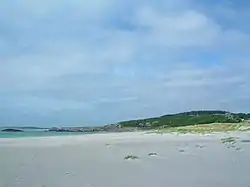
Hå municipality is located on the southwestern shore of Norway, along the North Sea. The municipality is located mostly in the very flat, coastal Jæren district. The southeastern part of the municipality begins to get a little hilly and rocky and it marks the border of the Dalane district (located to the south and east). Much of the land in Hå is used for agriculture because of its flat landscape. The river Hååna runs through the municipality. The shoreline of the municipality is marked by the Kvassheim Lighthouse and Obrestad Lighthouse.[27]
Settlements
| Name | Population | Area (km2) | Population density per km2 |
|---|---|---|---|
| Brusand | 428 | 0.2 | 2,140 |
| Hæen | 588 | 0.43 | 1,367 |
| Nærbø | 6,995 | 3.28 | 2,133 |
| Ogna | 360 | 0.31 | 1,161 |
| Sirevåg | 627 | 0.7 | 896 |
| Varhaug | 3,114 | 1.57 | 1,983 |
| Vigrestad | 2,116 | 1.18 | 1,793 |
Weather
Hå has a temperate oceanic climate (Cfb), also known as marine west coast climate. The average date for the last overnight freeze (low below 0 °C (32.0 °F)) in spring is 16 April[29] and average date for first freeze in autumn is 10 November[30] giving a frost-free season of 207 days (1981-2010 average).
| Climate data for Obrestad Lighthouse in Hå 1991-2020 | |||||||||||||
|---|---|---|---|---|---|---|---|---|---|---|---|---|---|
| Month | Jan | Feb | Mar | Apr | May | Jun | Jul | Aug | Sep | Oct | Nov | Dec | Year |
| Average high °C (°F) | 4.4 (39.9) |
3.9 (39.0) |
5.2 (41.4) |
8.4 (47.1) |
11.5 (52.7) |
14 (57) |
16.8 (62.2) |
17.8 (64.0) |
15.1 (59.2) |
11.4 (52.5) |
7.9 (46.2) |
5.5 (41.9) |
10.2 (50.3) |
| Daily mean °C (°F) | 2.8 (37.0) |
2 (36) |
3.1 (37.6) |
5.9 (42.6) |
9.1 (48.4) |
11.7 (53.1) |
14.3 (57.7) |
15.1 (59.2) |
12.9 (55.2) |
9.2 (48.6) |
5.9 (42.6) |
3.6 (38.5) |
8.0 (46.4) |
| Average low °C (°F) | 0.4 (32.7) |
−0.3 (31.5) |
1 (34) |
3.4 (38.1) |
6.5 (43.7) |
9.5 (49.1) |
12.2 (54.0) |
12.7 (54.9) |
10.6 (51.1) |
6.9 (44.4) |
3.6 (38.5) |
1.1 (34.0) |
5.6 (42.2) |
| Average precipitation mm (inches) | 132 (5.2) |
100 (3.9) |
88 (3.5) |
67 (2.6) |
64 (2.5) |
67 (2.6) |
88 (3.5) |
127 (5.0) |
130 (5.1) |
155 (6.1) |
152 (6.0) |
130 (5.1) |
1,309 (51.5) |
| Average precipitation days (≥ 1 mm) | 15.0 | 11.2 | 13.3 | 11.2 | 11.5 | 10.7 | 11.4 | 13.9 | 16.6 | 17.5 | 18.3 | 16.6 | 167.2 |
| Source 1: yr.no/Norwegian Meteorological Institute (mean, precipitation][31] | |||||||||||||
| Source 2: NOAA-WMO averages 91-2020 Norway [32] | |||||||||||||
Transportation
The Sørlandet Line runs through the municipality, making several stops. The stations in Hå include Brusand Station, Nærbø Station, Ogna Station, Sirevåg Station, Varhaug Station, and Vigrestad Station.
Notable people
- Jacob Rasch (1669 in Ogna – 1737), the rector of Christiania Cathedral School from 1706 to 1737
- Sven Aarrestad (1850 in Varhaug – 1942), a writer, politician, and leader in the Norwegian temperance movement
- Tor Obrestad (1938 in Hå – 2020), a Norwegian novelist, poet, and documentary writer
- Gunnar Torvund (1948 in Nærbø – 2019), a Norwegian sculptor
- Kjell Arild Pollestad (born 1949 in Hå), an author, theologian, philologist, and Dominican priest
- Magnus Matningsdal (born 1951 in Hå), a judge and a Supreme Court Justice from 1997
- Helge Torvund (born 1951 in Hå), a psychologist, poet, literary critic, and children's writer
- Geir Pollestad (born 1978 in Høyland), a politician and government minister
- Vidar Nisja (born 1986 in Vigrestad), a Norwegian football midfielder with 324 club caps
References
- "Navn på steder og personer: Innbyggjarnamn" (in Norwegian). Språkrådet.
- "Forskrift om målvedtak i kommunar og fylkeskommunar" (in Norwegian). Lovdata.no.
- Statistisk sentralbyrå. "Table: 06913: Population 1 January and population changes during the calendar year (M)" (in Norwegian).
- Statistisk sentralbyrå. "09280: Area of land and fresh water (km²) (M)" (in Norwegian).
- Jukvam, Dag (1999). Historisk oversikt over endringer i kommune- og fylkesinndelingen (PDF) (in Norwegian). Statistisk sentralbyrå. ISBN 9788253746845.
- Rygh, Oluf (1915). Norske gaardnavne: Stavanger amt (in Norwegian) (10 ed.). Kristiania, Norge: W. C. Fabritius & sønners bogtrikkeri. p. 104.
- "Civic heraldry of Norway - Norske Kommunevåpen". Heraldry of the World. Retrieved 2 July 2023.
- "Hå, Rogaland (Norway)". Flags of the World. Retrieved 2 July 2023.
- "Godkjenning av våpen og flagg". Lovdata.no (in Norwegian). Norges kommunal- og arbeidsdepartementet. 4 July 1991. Retrieved 2 July 2023.
- Hansen, Tore; Vabo, Signy Irene, eds. (20 September 2022). "kommunestyre". Store norske leksikon (in Norwegian). Kunnskapsforlaget. Retrieved 14 October 2022.
- "Tall for Norge: Kommunestyrevalg 2019 - Rogaland". Valg Direktoratet. Retrieved 5 July 2020.
- "Table: 04813: Members of the local councils, by party/electoral list at the Municipal Council election (M)" (in Norwegian). Statistics Norway.
- "Tall for Norge: Kommunestyrevalg 2011 - Rogaland". Valg Direktoratet. Retrieved 5 July 2020.
- "Kommunestyrevalget 1995" (PDF) (in Norwegian). Oslo-Kongsvinger: Statistisk sentralbyrå. 1996. Retrieved 5 July 2020.
- "Kommunestyrevalget 1991" (PDF) (in Norwegian). Oslo-Kongsvinger: Statistisk sentralbyrå. 1993. Retrieved 5 July 2020.
- "Kommunestyrevalget 1987" (PDF) (in Norwegian). Oslo-Kongsvinger: Statistisk sentralbyrå. 1988. Retrieved 5 July 2020.
- "Kommunestyrevalget 1983" (PDF) (in Norwegian). Oslo-Kongsvinger: Statistisk sentralbyrå. 1984. Retrieved 5 July 2020.
- "Kommunestyrevalget 1979" (PDF) (in Norwegian). Oslo: Statistisk sentralbyrå. 1979. Retrieved 5 July 2020.
- "Kommunevalgene 1975" (PDF) (in Norwegian). Oslo: Statistisk sentralbyrå. 1977. Retrieved 5 July 2020.
- "Kommunevalgene 1972" (PDF) (in Norwegian). Oslo: Statistisk sentralbyrå. 1973. Retrieved 5 July 2020.
- "Kommunevalgene 1967" (PDF) (in Norwegian). Oslo: Statistisk sentralbyrå. 1967. Retrieved 5 July 2020.
- "Kommunevalgene 1963" (PDF) (in Norwegian). Oslo: Statistisk sentralbyrå. 1964. Retrieved 5 July 2020.
- "Liste over ordførarar i Hå". Hå kommune (in Norwegian). 7 November 2019. Retrieved 2 July 2023.
- Statistisk sentralbyrå. "Table: 06913: Population 1 January and population changes during the calendar year (M)" (in Norwegian).
- Statistisk sentralbyrå. "Folketelling 1960" (PDF) (in Norwegian).
- Universitetet i Tromsø – Norges arktiske universitet. "Censuses in the Norwegian Historical Data Archive (NHDC)".
- Store norske leksikon. "Hå" (in Norwegian). Retrieved 23 June 2016.
- Statistisk sentralbyrå (1 January 2015). "Urban settlements. Population and area, by municipality".
- "Siste frostnatt om våren". 4 May 2012.
- "Første frostnatt". 25 September 2013.
- "eKlima Web Portal".
- "NOAA WMO normals Norway 1991-2020".
External links
 Media related to Hå at Wikimedia Commons
 The dictionary definition of Hå at Wiktionary
 Rogaland travel guide from Wikivoyage
- Municipal fact sheet from Statistics Norway (in Norwegian)
| |||||||
 | Towns and cities |
|  | ||||
| Municipalities | |||||||