Haneda Route
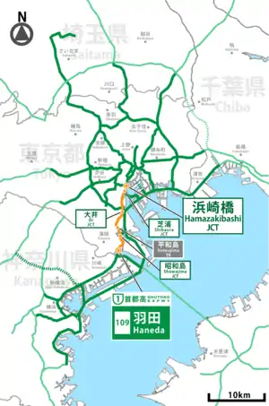
The Haneda Route (羽田線, Haneda-sen), signed as Route 1, is one of the tolled routes of the Shuto Expressway system serving the Greater Tokyo Area. It is one two expressways signed as Route 1 in the system, the other expressway signed as Route 1 is the Ueno Route. The route is a 13.8-kilometer (8.6 mi) long radial highway running south from the ward of Minato in central Tokyo to the ward of Ōta. It connects Tokyo's Inner Circular Route in central Tokyo to Haneda International Airport, one of the Tokyo area's two international airports, as well as the Yokohane Route, which leads to Kawasaki and Yokohama in Kanagawa Prefecture.
 首都高速1号羽田線 | |
|---|---|
 | |
| Route information | |
| Maintained by Metropolitan Expressway Company Limited | |
| Length | 12.5 km (7.8 mi) |
| Existed | 1963–present |
| Major junctions | |
| North end | Hamazakibashi Junction in Minato, Tokyo |
| South end | Haneda entrance/exit in Ōta, Tokyo |
| Location | |
| Country | Japan |
| Highway system | |
History
The Haneda Route was opened in four stages during the 1960s. The first section of the Haneda Route between Hamazakibashi and Shibaura was opened to traffic on 20 December 1962. The second section to be completed between Shibaura and Suzugamori was finished on 21 December 1963. The third section between Suzugamori and Haneda-nishi was opened on 2 August 1964. The fourth and final section between Haneda-nishi and Haneda was opened on 21 December 1966.[1]
Junction list
| Exit number |
Exit/interchange name | Connecting line name | Km from start | Notes | Municipality |
|---|---|---|---|---|---|
| - | Hamazakibashi JCT | Route C1 Inner Loop to Ginza and Hakozaki |
0.0 | Minato-ku | |
| - | Shibaura JCT | Route 11 to Kuko-chuo (Haneda Airport) and Bayshore Route via Rainbow Bridge | 0.5 | Ginza/Shinjuku area connection | |
| 101 | Shibaura | Tokyo Metropolitan Road No. 316 | 1.7 | Ginza/Shinjuku area entrance/exit | |
| 102 | 1.7 | Haneda/Yokohama area entrance/exit | |||
| - | Ōi JCT | 5.5 | To inbound from Bayshore Route only | Shinagawa-ku | |
| 103 | Katsushima | Tokyo Metropolitan Road No. 316 | 6.9 | Inbound exit/outbound entrance | |
| 104 | Suzugamori | National Route 15 | 7.5 | Outbound exit/inbound entrance | |
| 105 | Heiwajima | Kannana-dori (Tokyo's #7 ring road) | 9.1 | Ginza/Shinjuku area entrance/exit | Ota-ku |
| - | Heiwajima parking | - | |||
| - | - | Closed May 20, 2018[2] | |||
| 106 | Heiwajima | 9.1 | Daishi/Yokohama area
entrance/exit | ||
| - | Showajima JCT | 9.7 | Haneda/Yokohama Park
area connection | ||
| - | Haneda Tunnel | - | Vehicles with dangerous goods prohibited[3][4] | ||
| 107 | Kuko-nishi | Haneda Airport (West Entrance) | 11.3 | Ginza/Higashi Kanto area entrance/exit | |
| 109 | Haneda | Kampachi-dori (Tokyo's #8 ring road) | 12.5 | Entrance to Tokyo | |
| 150 | 12.5 | Yokohama area entrance | |||
See also
References
- "首都高の歴史". Metropolitan Expressway (in Japanese). Retrieved 8 November 2019.
- "平和島本線料金所、大井本線料金所の運用停止等について〜よりスムーズな通行を目指して〜" (PDF) (Press release). 首都高速道路. 25 April 2018. Retrieved 3 June 2018.
- "第3回 水底トンネル等における危険物積載車両の通行の禁止又は制限に関する審議会". 日本高速道路保有・債務返還機構. Retrieved 23 February 2016.
- "主要な水底トンネル等の危険物積載車両の通行規制状況" (PDF). 日本高速道路保有・債務返還機構. Retrieved 23 February 2016.
External links
 Media related to Category:Route 1 (Shuto Expressway) at Wikimedia Commons