Hatchet Lake Denesuline First Nation
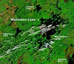
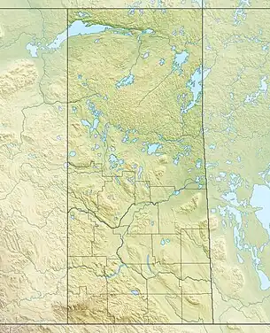
Hatchet Lake Denesuline Nation (Chipewyan: Tthęł Tué Dene[5][6]) is a Denesuline First Nation in northern Saskatchewan. The main settlement, Wollaston Lake, is an unincorporated community on Wollaston Lake in the boreal forest of north-eastern Saskatchewan, Canada.
 | |
| People | Denesuline |
|---|---|
| Treaty | Treaty 10 |
| Headquarters | Wollaston Lake |
| Province | Saskatchewan |
| Land[1] | |
| Reserve(s) | |
| Land area | 110.2 km2 |
| Population (2021)[2] | |
| On reserve | 1450 |
| Off reserve | 463 |
| Total population | 1913 |
| Government[3] | |
| Chief | Bartholomew Tsannie |
| Tribal Council[4] | |
| Prince Albert Grand Council | |


The population centre comprises the northern settlement of Wollaston Lake, an unincorporated community in the Northern Saskatchewan Administration District, and the adjoining First Nations community of Wollaston Post, the administrative headquarters of the Hatchet Lake Dene First Nation band government.
Access is provided by Wollaston Lake Airport and Highway 905. With the highway on the west side of the lake and the community on the east, access from the highway is provided by an ice road in the winter and by the Wollaston Barge Ferry in the summer. Highway 995 services the community and runs from the airport to the barge.
Demographics
In the 2021 Census of Population conducted by Statistics Canada, the Northern Settlement of Wollaston Lake had a population of 96 living in 30 of its 39 total private dwellings, a change of -7.7% from its 2016 population of 104. With a land area of 1.45 km2 (0.56 sq mi), it had a population density of 66.2/km2 (171.5/sq mi) in 2021.[7] The population of Wollaston Post (Lac La Hache 220, IR, Saskatchewan) was 1,251 in 2011.[8]
| 2011 | |
|---|---|
| Population | 1,251 (+26.6% from 2006) |
| Land area | 110.87 km2 (42.81 sq mi) |
| Population density | 11.3/km2 (29/sq mi) |
| Median age | 20.1 (M: 20.9, F: 19.9) |
| Private dwellings | 244 (total) |
| Median household income |
Band government
Wollaston Post is the administrative centre of the Hatchet Lake Dene Nation. The First Nations band government had a total registered membership of 1,760 in January 2015 with 1,369 members residing on-reserve and 391 members residing at locations off-reserve. Under a Custom Electoral System members choose one Chief and six councillors. Hatchet Lake is affiliated with the Prince Albert Grand Council. [12]
Territory
Hatchet Lake Dene Nation has one territory (Lac La Hache 220). Lac La Hache 220 is 11,020 hectares (27,200 acres) 58.1957°N 103.0225°W. It includes many islands the largest being Strong Island, Paul Island, Labby Island and Jackpine Island and peninsulas north of the settlement in the area surrounding Fidler Bay and Kempton Bay.[12][13]
Climate
Wollaston Lake has a subarctic climate (Dfc) with mild, wet summers and long, severely cold winters.
| Climate data for Wollaston Lake | |||||||||||||
|---|---|---|---|---|---|---|---|---|---|---|---|---|---|
| Month | Jan | Feb | Mar | Apr | May | Jun | Jul | Aug | Sep | Oct | Nov | Dec | Year |
| Average high °C (°F) | −20.0 (−4.0) |
−15.5 (4.1) |
−8.1 (17.4) |
2.8 (37.0) |
10.8 (51.4) |
17.2 (63.0) |
20.5 (68.9) |
18.5 (65.3) |
10.9 (51.6) |
3.0 (37.4) |
−9.1 (15.6) |
−17.8 (0.0) |
1.1 (34.0) |
| Daily mean °C (°F) | −24.5 (−12.1) |
−20.5 (−4.9) |
−14.1 (6.6) |
−3.0 (26.6) |
5.3 (41.5) |
11.7 (53.1) |
15.4 (59.7) |
13.5 (56.3) |
6.8 (44.2) |
−0.4 (31.3) |
−12.7 (9.1) |
−21.9 (−7.4) |
−3.7 (25.3) |
| Average low °C (°F) | −29.0 (−20.2) |
−25.5 (−13.9) |
−20.1 (−4.2) |
−8.7 (16.3) |
−0.1 (31.8) |
6.2 (43.2) |
10.3 (50.5) |
8.6 (47.5) |
2.8 (37.0) |
−3.7 (25.3) |
−16.3 (2.7) |
−25.9 (−14.6) |
−8.5 (16.8) |
| Average precipitation mm (inches) | 22 (0.9) |
17 (0.7) |
25 (1.0) |
29 (1.1) |
41 (1.6) |
64 (2.5) |
89 (3.5) |
68 (2.7) |
60 (2.4) |
43 (1.7) |
32 (1.3) |
24 (0.9) |
514 (20.3) |
| Source: http://en.climate-data.org/location/107968/ | |||||||||||||
See also
References
- "First Nation Detail". Crown–Indigenous Relations and Northern Affairs Canada. Government of Canada. Retrieved 28 December 2019.
- "First Nation Detail". Crown–Indigenous Relations and Northern Affairs Canada. Government of Canada. Retrieved 28 December 2019.
- "First Nation Detail". Crown–Indigenous Relations and Northern Affairs Canada. Government of Canada. Retrieved 28 December 2019.
- "First Nation Detail". Crown–Indigenous Relations and Northern Affairs Canada. Government of Canada. Retrieved 28 December 2019.
- "Saskatchewan Indigenous Cultural Centre - Dene History". Archived from the original on 25 October 2021. Retrieved 25 October 2021.
- Smith, James G. E. "Historical Changes in the Chipewyan Kinship System". In DeMallie, Raymond J.; Ortiz, Alfonso (eds.). North American Indian Anthropology: Essays on Society and Culture. Norman and London: University of Oklahoma Press. p. 75. ISBN 9780806126142.
- "Population and dwelling counts: Canada and designated places". Statistics Canada. 9 February 2022. Retrieved 31 August 2022.
- "Statistics Canada. 2012. Lac La Hache 220, Saskatchewan". Retrieved 28 October 2012.
- "2011 Community Profiles". 2011 Canadian Census. Statistics Canada. 21 March 2019. Retrieved 28 January 2013.
- "2006 Community Profiles". 2006 Canadian Census. Statistics Canada. 20 August 2019.
- "2001 Community Profiles". 2001 Canadian Census. Statistics Canada. 18 July 2021.
- "AANDC (First Nation Profile Hatchet Lake)". Crown–Indigenous Relations and Northern Affairs Canada. Government of Canada. Retrieved 15 March 2013.
- "Natural Resources Canada-Canadian Geographical Names (Lac la Hache 220)". Retrieved 4 February 2015.
