Haveli District
The Haveli District (Urdu: ضلع حویلی) is a district of Pakistan-administered Azad Kashmir in the disputed Kashmir region.[1] It is one of the 10 districts of Pakistan-administered dependent territory of Azad Kashmir. It was previously a tehsil of the Bagh District but was elevated to district status on 1 July 2009.[2]
Haveli District
ضلع حویلی | |
|---|---|
District of Azad Kashmir administered by Pakistan[1] | |
 Haveli Kahutta | |
Interactive map of Haveli district | |
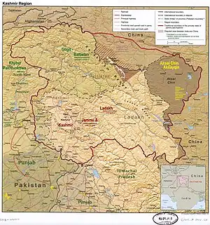 A map showing Pakistani-administered Pakistan Occupied Kashmir (shaded in sage green) in the disputed Kashmir region[1] | |
| Coordinates (Forward Kahuta): 33°56′N 74°06′E | |
| Administering country | Pakistan |
| Territory | Azad Kashmir |
| Division | Poonch Division |
| Headquarters | Forward Kahuta |
| Government | |
| • Type | District Administration |
| • Deputy Commissioner | N/A |
| • District Police Officer | N/A |
| • District Health Officer | N/A |
| Area | |
| • Total | 598 km2 (231 sq mi) |
| Population (2017) | |
| • Total | 152,124 |
| • Density | 268/km2 (690/sq mi) |
| Languages | |
| • Official | Urdu |
| • Spoken | |
| Number of Tehsils | 3 |
According to the 2017 census, the district has a population of 152,124.[3] The main native languages are Pahari (estimated to be spoken by around 65% of the inhabitants), Gujari (c. 30%), and Kashmiri (c. 5%).[4][5] Haveli contain many torrism places such as
Neil feri meadows
Hillan waterfall
Badori
Mahmood gali

Administration
The Haveli District is divided into three tehsils:
- Haveli Tehsil
- Khurshidabad Tehsil
- Mumtazabad Tehsil
The district has 12 union councils consisting of 95 villages and one municipal corporation, Forward Kahuta.
Geography
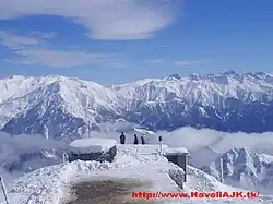
The Haveli District is situated at a high altitude of approximately 8,000 feet above sea level. Heavy snowfall occurs regularly throughout the year. Darra Haji Peer, Lasdana, Sindhgala, Neel Kunth, Aliabad, Sheraziabad, Kalamula, Jabbi Syedan, and Mohri Syed Ali are all well known tourist locations. The Bedori Top, at 12,228 feet, is the highest peak in the district.[6]*Many people from the district have migrated abroad, and some of them serve in key positions in Pakistan. The Haveli District is bounded on the north and north-east by the Baramulla District of Indian-administered Jammu and Kashmir, on the south-east and south by the Poonch District of Indian-administered Jammu and Kashmir, and on the west by the Bagh District and the Poonch District of Azad Kashmir.
Education
According to the Alif Ailaan Pakistan District Education Rankings 2017, the Haveli District is ranked 33 out of 148 districts in education. For facilities and infrastructure, the district is ranked 146 out of 148.[7]
References
- The application of the term "administered" to the various regions of Kashmir and a mention of the Kashmir dispute is supported by the tertiary sources (a) through (e), reflecting due weight in the coverage. Although "controlled" and "held" are also applied neutrally to the names of the disputants or to the regions administered by them, as evidenced in sources (h) through (i) below, "held" is also considered politicized usage, as is the term "occupied," (see (j) below).
(a) Kashmir, region Indian subcontinent, Encyclopaedia Britannica, retrieved 15 August 2019 (subscription required) Quote: "Kashmir, region of the northwestern Indian subcontinent ... has been the subject of dispute between India and Pakistan since the partition of the Indian subcontinent in 1947. The northern and western portions are administered by Pakistan and comprise three areas: Azad Kashmir, Gilgit, and Baltistan, the last two being part of a territory called the Northern Areas. Administered by India are the southern and southeastern portions, which constitute the state of Jammu and Kashmir but are slated to be split into two union territories.";
(b) Pletcher, Kenneth, Aksai Chin, Plateau Region, Asia, Encyclopaedia Britannica, retrieved 16 August 2019 (subscription required) Quote: "Aksai Chin, Chinese (Pinyin) Aksayqin, portion of the Kashmir region, at the northernmost extent of the Indian subcontinent in south-central Asia. It constitutes nearly all the territory of the Chinese-administered sector of Kashmir that is claimed by India to be part of the Ladakh area of Jammu and Kashmir state.";
(c) "Kashmir", Encyclopedia Americana, Scholastic Library Publishing, 2006, p. 328, ISBN 978-0-7172-0139-6 C. E Bosworth, University of Manchester Quote: "KASHMIR, kash'mer, the northernmost region of the Indian subcontinent, administered partlv by India, partly by Pakistan, and partly by China. The region has been the subject of a bitter dispute between India and Pakistan since they became independent in 1947";
(d) Osmańczyk, Edmund Jan (2003), Encyclopedia of the United Nations and International Agreements: G to M, Taylor & Francis, pp. 1191–, ISBN 978-0-415-93922-5 Quote: "Jammu and Kashmir: Territory in northwestern India, subject to a dispute between India and Pakistan. It has borders with Pakistan and China."
(e) Talbot, Ian (2016), A History of Modern South Asia: Politics, States, Diasporas, Yale University Press, pp. 28–29, ISBN 978-0-300-19694-8 Quote: "We move from a disputed international border to a dotted line on the map that represents a military border not recognized in international law. The line of control separates the Indian and Pakistani administered areas of the former Princely State of Jammu and Kashmir.";
(f) Skutsch, Carl (2015) [2007], "China: Border War with India, 1962", in Ciment, James (ed.), Encyclopedia of Conflicts Since World War II (2nd ed.), London and New York: Routledge, p. 573, ISBN 978-0-7656-8005-1,The situation between the two nations was complicated by the 1957–1959 uprising by Tibetans against Chinese rule. Refugees poured across the Indian border, and the Indian public was outraged. Any compromise with China on the border issue became impossible. Similarly, China was offended that India had given political asylum to the Dalai Lama when he fled across the border in March 1959. In late 1959, there were shots fired between border patrols operating along both the ill-defined McMahon Line and in the Aksai Chin.
(g) Clary, Christopher, The Difficult Politics of Peace: Rivalry in Modern South Asia, Oxford and New York: Oxford University Press, p. 109, ISBN 9780197638408,Territorial Dispute: The situation along the Sino-Indian frontier continued to worsen. In late July (1959), an Indian reconnaissance patrol was blocked, "apprehended," and eventually expelled after three weeks in custody at the hands of a larger Chinese force near Khurnak Fort in Aksai Chin. ... Circumstances worsened further in October 1959, when a major class at Kongka Pass in eastern Ladakh led to nine dead and ten captured Indian border personnel, making it by far the most serious Sino-Indian class since India's independence.
(h) Bose, Sumantra (2009), Kashmir: Roots of Conflict, Paths to Peace, Harvard University Press, pp. 294, 291, 293, ISBN 978-0-674-02855-5 Quote: "J&K: Jammu and Kashmir. The former princely state that is the subject of the Kashmir dispute. Besides IJK (Indian-controlled Jammu and Kashmir. The larger and more populous part of the former princely state. It has a population of slightly over 10 million, and comprises three regions: Kashmir Valley, Jammu, and Ladakh.) and AJK ('Azad" (Free) Jammu and Kashmir. The more populous part of Pakistani-controlled J&K, with a population of approximately 2.5 million.), it includes the sparsely populated "Northern Areas" of Gilgit and Baltistan, remote mountainous regions which are directly administered, unlike AJK, by the Pakistani central authorities, and some high-altitude uninhabitable tracts under Chinese control."
(i) Fisher, Michael H. (2018), An Environmental History of India: From Earliest Times to the Twenty-First Century, Cambridge University Press, p. 166, ISBN 978-1-107-11162-2 Quote: "Kashmir’s identity remains hotly disputed with a UN-supervised “Line of Control” still separating Pakistani-held Azad (“Free”) Kashmir from Indian-held Kashmir.";
(j) Snedden, Christopher (2015), Understanding Kashmir and Kashmiris, Oxford University Press, p. 10, ISBN 978-1-84904-621-3 Quote:"Some politicised terms also are used to describe parts of J&K. These terms include the words 'occupied' and 'held'." - "District Haveli (Kahutta)". Government of Azad Jammu & Kashmir. Archived from the original on 8 April 2014. Retrieved 6 July 2013.
- "Census 2017: AJK population rises to over 4m". The Nation. Retrieved 2017-09-01.
- Statistical Year Book 2020 (PDF). Muzaffarabad: AJ&K Bureau Of Statistics. p. 140. Retrieved 3 March 2022.
- Shakil, Mohsin (2012). "Languages of Erstwhile State of Jammu Kashmir (A Preliminary Study)". p. 12.
- "Bedori Top Mountain Information".
- "Individual district profile link, 2015". Alif Ailaan. Retrieved 2015-05-06.
Provincial capital: Muzaffarabad | ||
| Mirpur |  | |
| Muzaffarabad | ||
| Poonch | ||