Head Waters, Virginia
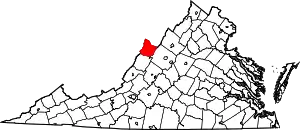
Head Waters (also Headwaters) is an unincorporated community in Highland County, Virginia, United States.[1] Head Waters is located approximately 4.25 miles (6.84 km) east of McDowell on US 250.[2][3] The South Fork South Branch Potomac River rises north of Head Waters,[4] hence the community's name.[5] Head Waters has a post office with ZIP code 24442.[6]
Head Waters, Virginia | |
|---|---|
_in_Head_Waters%252C_Highland_County%252C_Virginia.jpg.webp) A view of Head Waters, VA eastbound on U.S. 250 | |
 Head Waters  Head Waters | |
| Coordinates: 38°19′33″N 79°24′46″W | |
| Country | United States |
| State | Virginia |
| County | Highland |
| Elevation | 2,047 ft (624 m) |
| Time zone | UTC−5 (Eastern (EST)) |
| • Summer (DST) | UTC−4 (EDT) |
| ZIP codes | 24442 |
| GNIS feature ID | 1484004[1] |
References
- "Head Waters". Geographic Names Information System. United States Geological Survey, United States Department of the Interior. Retrieved December 19, 2013.
- Google (December 19, 2013). "Head Waters, Virginia" (Map). Google Maps. Google. Retrieved December 19, 2013.
- "Domestic Geographic Name Report Form - Head Waters, Virginia". U.S. Department of the Interior Board on Geographic Names. Retrieved December 19, 2013.
- "South Fork South Branch Potomac River". Geographic Names Information System. United States Geological Survey, United States Department of the Interior. Retrieved December 19, 2013.
- Scott, Chris (2008). Highland County. Arcadia Publishing. p. 10. ISBN 9780738553313.
- "Find Locations - Head Waters". United States Postal Service. Retrieved December 19, 2013.
Wikimedia Commons has media related to Head Waters, Virginia.
This article is issued from Wikipedia. The text is licensed under Creative Commons - Attribution - Sharealike. Additional terms may apply for the media files.
