Limited geography model
A limited geography model for the Book of Mormon is one of several theories by Latter Day Saint movement scholars that the book's narrative was a historical record of people in a limited geographical region, rather than of the entire Western Hemisphere as believed by nearly all early and present Latter Day Saints.[1]
| Part of a series on the |
| Book of Mormon |
|---|
 |
These models, developed in an effort to reconcile claims in the Book of Mormon with archaeology and geography, have situated the book's events in South America, Mesoamerica, and/or the Great Lakes area. One popular LDS theory places the setting for the Book of Mormon in the vicinity of Mexico and Central America surrounding the Isthmus of Tehuantepec.[2][3] Others recognize a setting among the mound builders as the book's original setting.[4] This North American setting has gained support from some notable members of the LDS community.[5] The mound builder setting parallels traditional settings of the Book of Mormon accepted during the 19th century, but is still a minority view in LDS academia.[6] The limited geography models are the result of a school of thought among Latter Day Saint scholars that for the text of the Book of Mormon to realistically be interpreted as a historical document, the events described therein must be limited to an area of several hundred square miles.[7]
However, narrowing the discussion to only one geographic model has proven problematic. Each of these models has sustained harsh criticisms, often from fellow LDS researchers, as they attempt to reconcile known archeological (and geographic) locations with claimed Book of Mormon lands and peoples, and to untangle other apparent contradictions and problems with each model in its turn.
These models have not changed the academic consensus outside the Latter Day Saint movement that the Book of Mormon is not an accurate description of ancient American history.[8] Archaeological evidence supporting the Book of Mormon's "Mound-builder" literary setting is not interpreted by mainstream academia as proving the historicity or divinity of the work.[9] The Book of Mormon is regarded by mainstream historians and literary experts as a work of 19th century American literature, in the "Mound-builder" genre[10] but not as history.
Background and history
The Book of Mormon describes a journey by a group of people led by a prophet named Lehi from the Old World to the New World in approximately 600 BC. The Book of Mormon also describes the journey of two other groups to America, called the people of Mulek,[11] and the Jaredites.[12] Given that the Book of Mormon describes inhabitants of the New World long before Lehi's arrival, LDS scholars have long taken a critical view regarding the assumption that no other people were present in the New World at the time of Lehi's arrival.
Janne M. Sjödahl was one of the earliest proponents of a limited geography model. In 1927, he stated that "students of the Book of Mormon should be cautioned against the error of supposing that all the American Indians are the descendants of Lehi, Mulek and their companions."[13][14]
In 1938, an LDS church study guide for the Book of Mormon stated that "the Book of Mormon deals only with the history and expansion of three small colonies which came to America, and it does not deny or disprove the possibility of other immigrations, which probably would be unknown to its writers."[13][15]
Another prominent proponent of the limited geography model was LDS scholar Hugh Nibley, who argued that the assumption that there were no other people present in the New World at the time of Lehi's arrival might be incorrect. In 1980, Nibley, referring to archaeological evidence, stated that the assumption of an empty New World represented a "simplistic reading" of the Book of Mormon.[13][16]
In the 1920s, LDS General Authority and historian B.H. Roberts questioned the assumption of a hemispheric geography and population model for the Book of Mormon. In his critical examination of the Book of Mormon, eventually published in 1985 under the title Studies of the Book of Mormon, Roberts affirmed that Book of Mormon peoples numbered and occupied "the land at least from Yucatan to Cumorah," and speculated that such peoples would have come "in contact with other races and tribes of men, if such existed in the New World within Book of Mormon times." Finally he asserted that "the area occupied by the Nephites and Lamanites would have to be extremely limited, much more limited, I fear, than the Book of Mormon would admit our assuming."[17]
Early in the twentieth century, RLDS (Reorganized Church of Jesus Christ of Latter Day Saints) members proposed a limited Mesoamerican geography for the Book of Mormon.[18] By the middle of the twentieth century, most LDS authors shared the belief that the Book of Mormon events took place within a limited region in Mesoamerica, and that others were present on the continent at the time of Lehi's arrival.[19] This geographical and population model was formally published in the official church magazine, The Ensign, in a two-part series published in September and October 1984.[20] This was followed by a book on the subject by LDS anthropologist John L. Sorenson in 1985.[21]
The proposal of a limited geography is coupled with the proposal that the American continents were already populated at the time of the arrival of Lehi's group. The presence of inhabitants on the American continents long before the arrival of Lehi's party is well supported by existing archaeological data. The most widely accepted theory among mainstream scientists is that native populations arrived via a land bridge in the Bering Strait approximately 14,000 years ago.[22]
Mesoamerican setting
According to a subset of LDS scholars investigating the field, the application of the Book of Mormon limited geography model to a Mesoamerican setting produces a "highly plausible match."[23] LDS scholars use "contextual knowledge" in order to establish a plausible setting for the cultural events of the Book of Mormon within the context of known Mesoamerican historical settings. The goal is to determine places and times at which Book of Mormon events occurred that correlate with similar events in the Mesoamerican historical record.[24] Based on textual analysis and comparison of the Book of Mormon limited geography model to existing geographical regions, time-lines and cultures, many LDS scholars believe that the Book of Mormon geography is centered in Mesoamerica around the Isthmus of Tehuantepec, in the area of current day Guatemala and the southern Mexico States of Tabasco, Chiapas, Oaxaca, Veracruz, and the surrounding area.[25]

Proposed locations of cities, events, and landmarks
Some LDS scholars believe that the Tehuantapec model provides enough of a match with existing geography, ancient cultures and ruins, to propose plausible locations for certain Book of Mormon places and events. Critics, on the other hand, insist that the Tehuantepec model is fundamentally flawed.[26]
Position of seas
The Book of Mormon refers to two lands, a land northward and a land southward.[27] The land northward was completely surrounded by water [28] and the land southward was nearly surrounded by water.[29] Jacob, the brother of Nephi described the land southward as being an "isle of the sea": "... for the Lord has made the sea our path, and we are upon an isle of the sea".[30] One author notes that the Hebrew term translated "isle" can also mean "coast", "border", "region" or "habitable land" and does not exclusively mean island.[31][32] The majority of references to seas refer to a sea east and west of the land northward and the land southward [33][34] The Isthmus of Tehuantepec borders the Gulf of Mexico on the north and the Pacific Ocean on the south.
The Old World Promised Land is bordered by inland bodies of water called "seas".[35] The Book of Mormon does not indicate that its every mention of "sea" relates to an Oceanic body of water. The text does not identify any of the seas that bordered Book of Mormon lands as the waters they crossed to arrive there.
The "narrow" neck of land
The Isthmus of Tehuantepec, at 125 miles (201 km) wide, is considered by some LDS scholars to be "just within the range of plausibility" for the "day and a half's journey for a Nephite" indicated by the text of the Book of Mormon,[36] although critics question this association.[37]
Location of the final battles of the Lamanites and the Nephites
Several proponents of the Tehuantapec model have proposed that the final battles of the Lamanites and the Nephite civilizations occurred at the Cerro El Vigia ("Lookout Hill"), a 3000 foot (800 m) tall extinct volcano located in the northwestern section of the Sierra de los Tuxtlas mountain range in Mexico. Significantly larger than the 110-foot (34 m) tall "Hill Cumorah" located in New York, the Cerro El Vigia is said to be a plausible location for the "Hill Ramah" and "Hill Cumorah" described in the Book of Mormon.[38]
Existence of ancient system of writing
Support for the hypothesis of Mesoamerica as a plausible location for a limited Book of Mormon geography requires that the ancient inhabitants have a highly developed system of writing. Mesoamerica is the only area in the Americas where evidence survives of an ancient system of writing.[39] There have been identified at least six pre-Christian era Mesoamerican systems of writing.[40] Although much of this writing has been deciphered, there are still instances of ancient writing from these cultures that scholars have not yet been able to translate.[41] However, the oral tradition of certain native people of "northern America" maintains the existence of an indigenous, pre-Columbian script.[42] More than one LDS researcher has concluded that various characters from "North America's first indigenous script" resemble characters believed to have been copied from the Book of Mormon plates.[43]
Presence of existing populations
The Mesoamerican Limited Geography Model suggests that the introduction of a small, external population into the existing Mesoamerican population would initially show little evidence in the archaeological record.[44] It is suggested by LDS scholars that certain cultural features spread out from the Mesoamerican area to surrounding regions over time after the arrival of external groups.[45]
Moroni and the final resting place of the plates
Several Book of Mormon geography models conflict with the western New York location of Cumorah where Joseph Smith reported finding the golden plates. This has led to an argument promoted by some LDS apologists, known as the "Two Cumorahs" theory.[46] Some LDS apologists and leaders take exception to the Two Cumorahs theory.[47][48] The Book of Mormon states that some final battles of the Nephite people took place near "the narrow passage".[49] Mesoamerican setting advocates seek to place this geographic feature in Central America.[50] Others point out that there are several isthmuses, or narrow moraines, in the vicinity of western New York, which would simplify the task of locating Cumorah.[51]
In the Book of Mormon narrative, the Nephite historian Mormon states that he "hid up in the hill Cumorah all the records which had been entrusted to me by the hand of the Lord, save it were these few plates which I gave unto my son Moroni."[52] The "hill Cumorah" referred to by Mormon is the hill located near the scene of the final battle between the Nephites and the Lamanites. Moroni continues to record information on these plates as late as 35 years after they were given to him.[53] Some LDS apologists suggest that the method by which the plates reached New York was that Moroni carried them there during this long interim.[54] (On this point, no Central or South American setting for the Book of Mormon is exactly limited, in that these settings require Moroni to have traveled thousands of miles beyond the confines of his homeland to deposit the plates.[55])
One author criticizes this theory as being "problematic" because "Moroni makes it clear that he buried the plates in the vicinity of the Nephites' destruction, not 2,000 miles (3,200 km) away in some remote region." To support this assumption, it is postulated that Moroni buried the plates near the scene of the final battle and then returned 20 years later to retrieve them and add information to them before his final farewell, in which he states that his intention to "seal up these records"[56] Some have argued that Moroni may have hidden the plates in a different location, as a later passage states that Moroni "wander[ed] whithersoever [he could] for the safety of [his] own life. Wherefore, [he] wr[o]te a few more things, contrary to that which [he] had supposed."[57]
LDS apologist Vincent Coon cites non-LDS archaeologist Salvatore Trento, who posits the possibility that Joseph Smith actually discovered buried metal tablets engraved with "weird markings".[58] Trento notes comparable discoveries in Northeastern America which Coon points out are not likely the result of a singular ancient individual traveling thousands of miles from Central or South America.[59]
The "two Cumorahs" theory is considered preposterous by some. Historian and journalist Hampton Sides remarks, "As fantastic as it may seem, [LDS apologist John] Sorenson actually argues that there were two Cumorahs: one in Mexico where the great battle took place, and where Moroni buried a longer, unexpurgated version of the golden Nephite records; and one near Palmyra, New York, where Moroni eventually buried a condensed version of the plates after lugging them on an epic trek of several thousand miles."[60] (Such criticism would also implicitly apply to a South American limited geography model, discussed below.)
Particularly troublesome to the Mesoamerica geography hypothesis, is the fact LDS scripture places Cumorah, a land which the Book of Mormon says is "in a land of many waters, rivers, and fountains", near New York's Finger Lakes, just south of Lake Ontario.[61] Based on LDS scripture and statements of early church members, several General Authorities of the church have publicly opposed the idea that Cumorah is in Mexico or Central America.[62]
Analysis of the Book of Mormon text shows that Zarahemla cannot be thousands of miles distance from the land Cumorah.[63]
Zelph
The story of Zelph is used to support the idea the Joseph Smith promoted a hemispheric geography for the Book of Mormon, or perhaps a Great Lakes setting (see below), and would not be compatible with a limited Mesoamerican setting.
Archeological criticism
The Limited Mesoamerican Geography Model has been critiqued, suggesting that it is not an adequate explanation for Book of Mormon geography and that the locations, events, and flora and fauna described in it do not precisely match.[64][65] In response to one of these critiques in 1994, Sorenson reaffirmed his proposal for a limited Mesoamerican geographical setting.[66]
Critics note that several of the cardinal directions discussed in the Book of Mormon (such as east and west) more closely correspond to perpendicular cardinal directions (such as north and south) in the proposed geography of the Mesoamerican limited geography model. Apologists discuss this, and draw parallels with other ancient cultures wherein cardinal directions are rendered differently.[67] Another researcher has suggested that ancient Maya directions were set 45° different from our own.[68]
Textual criticism
It is unlikely that things as common as monkeys (translated "apes" in the King James Version of the Bible) and palm trees could escape mention in the Book of Mormon had Mesoamerica been the area in which the civilizations describes in it existed. In the Book of Mormon, the only reference to anything like a jaguar is "leopard", and this occurs only in quotations from the biblical prophet Isaiah. On the other hand, "lions" (possibly cougars) are mentioned more than once in the Book of Mormon.[69]
Great Lakes setting
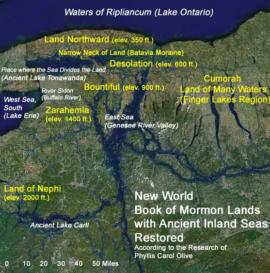
Some LDS researchers have proposed a limited Great Lakes setting for the Book of Mormon.[70] One of these proposals has the histories of the Jaredite, Nephite and Lamanite civilizations taking place in a small area of southern Ontario and western New York. According to Delbert Curtis, the seas surrounding the land are said to be Lakes Huron, Ontario, and Erie.[71]
Favoring a setting more localized near the Great Lakes, Olive writes that Lehi's company sailed across the Gulf of Mexico and up interconnected North American rivers such as the Mississippi, Ohio and other navigable ancient water ways, to within a short distance of the Book of Mormon's "west sea" or "west sea, south" – the freshwater Great Lake Erie (according to Olive).[72] Both May and Olive agree that the northern arrivals of other ancient peoples in the Book of Mormon occurred by way of the Atlantic Ocean and St. Lawrence Seaway.
It is clear that the Book of Mormon "land northward" has a limiting northern boundary. The land is likely bounded on the north by the exceedingly large "waters of Ripliancum",[73] whereas Southern Mexico is open on the north to the continent.
In counties near Lake Ontario, E.G. Squier, commissioned by the Smithsonian Institution, documented the remains of numerous earth and timber "castles" and "towns" constructed by the indigenous peoples of western New York in 1849.[74] With the expansion of modern civilization, aboriginal monuments and antiquities have vanished from the New York landscape.[75]
The breadth of "Bountiful" (or the narrow neck of land discussed above), according to Olive, Coon and Hamilton, is approximately the 33 mi (53 km) distance from Batavia, New York, westward to the coast of Lake Erie – along the line of the Onondaga scarp which fails the scriptural requirement that 1.5 day stretch of land be to the east of the narrow neck. The "narrow neck of land" according to Olive is a narrow moraine near Batavia.[76]
Statements by Joseph Smith
Joseph Smith was open to the possibility that Book of Mormon peoples migrated from lands as far north as present-day Quebec to Mexico and Central America, but clearly placed the arrival of the Jaredites in the region of "the lake country of America" (near Lake Ontario).[77] Non-Mormon Josiah Priest, whose written work Joseph Smith editorialized, explicitly associated the title "lake country" with the Great Lakes region of America.[78]
From written statements made by Joseph Smith, it may be concluded that Book of Mormon peoples or their descendants migrated from "the lake country of America" (near Lake Ontario) to Mexico and Central America. Serving as both official and acting editor in the spring and summer of 1842, Joseph Smith published several articles in the Times and Seasons pertinent to Book of Mormon geography. We can readily identify Joseph's editorials as they end with his "ED". In one of these articles, the editor compares a Native American Flood Legend (Ontario County, N. Y.) with one from Mexico. Joseph informs us that the Jaredites arrived in the "lake country of America ... choice above all the land[s] of the earth" [79] In May, 1842 Joseph Smith published an editorial on "A CATACOMB OF MUMMIES FOUND IN KENTUCKY" which he correlated with "descendents of Israel coming to this continent ..." and offered it as "strong evidence of the authenticity of the Book of Mormon". Joseph had previously read John Lloyd Stephens' two volume work and recommended it as supporting "the testimony of the Book of Mormon" and as "the most correct luminous & comprehensive" of all histories "pertaining to the antiquities of this country" [80] Joseph evidently believed that Book of Mormon peoples had migrated to Central America, but nowhere does he specifically state that Book of Mormon lands are to be found there [81] Smith relied mainly on the work of Josiah Priest (for whom he had less regard) to provide material support for a northern American Book of Mormon setting [82] The anonymous "ZARAHEMLA" article (October 1, 1842) alleges that the Central American ruins of Quirigua (now known to date more recent than Book of Mormon times) are none other than the ruins of Zarahemla or some other Book of Mormon city. This sensational piece was published in the same issue as a signed letter to the church from Joseph Smith (who was then in hiding). Inferred in Joseph Smith's epistle (dated September 6, 1842) is the Finger Lakes location of Cumorah.
Heartland model
A somewhat more expansive, though overlapping limited geography model, is known as the "Heartland Model" (or "Heartland theory"). It postulates that the events described in the Book of Mormon took place, primarily, in the "heartland" of North America, including the Great Lakes region, but also in regions somewhat further afield.[83]
Among the model's proposals are that Mound Builders, including the Hopewell and the Adena, were among those peoples described in accounts of events in Book of Mormon books such as Alma and Helaman. The Mississippi River is identified as the River Sidon, and Big Spring (in Carter County, Missouri) as the Waters of Mormon. The Niagara Falls region has been described as the "narrow neck of land" mentioned in Alma. In addition, the Appalachian region of Tennessee is claimed by some to be the Land of Nephi.[84]
In this model, the Hill Cumorah is located in upstate New York. It is the same hill referenced in the Book of Mormon as the location of the destruction of both the Jaredite (arguably associated with the Adena people) and Nephite (arguably the Hopewell) peoples, and the same hill in which Mormon ostensibly hides the records, and from which Joseph Smith ostensibly retrieved them in 1827.
In 2016 this theory was described as a "movement" among Mormons.[85][86] Proponents see this new model as a way of better supporting the historical authenticity of the Book of Mormon. [87]
Criticism
Mesoamerican setting advocate John E. Clark writes that all seas that bordered New World Book of Mormon lands "had to be the Pacific and Atlantic oceans ..."[88] However, this statement is without clear scriptural support. Citing Alma 22:28, Clark alleges that "Lehi arrived from the Old World across the west sea". Great Lakes, and American Heartland setting advocates point out that this verse (cited by Clark), does not in fact say that Lehi voyaged across "the west sea".[89] Clark alleges that the designations of west and east seas in the Book of Mormon "... are tied to ... original arduous journeys across oceans and the receding direction of their [the voyaging immigrant's] forfeited homeland." But LDS scripture does not clearly identify "the waters of the great deep", "the great waters" or "the many waters" that Book of Mormon peoples voyaged across, with either of the seas immediately west or east of the lands of Zarahemla and Nephi.[90] Clark's broad oceanic reference frame(s) seems inconsistent with the clearly local designation of "the sea on the west and on the east" of a terrestrial location "by the narrow pass ...".[91] It can only be concluded, based on LDS scripture, that the American land of "first inheritance" extended to and included a place by the shore of a sea that situated west relative to the land of Nephi. To allege that all Book of Mormon seas are oceans is to make extrapolations beyond what the scripture actually states.[92] The logic that "sea equals ocean", fails in the case of many biblical verses that refer to a "sea" or "the sea".[93] Even "the great sea" (the Mediterranean),[94] bordering ancient Israel, is essentially an inland body of water.
Rejecting hemispheric settings and locating Cumorah in upstate New York,[95] LDS authors Olive, May and others, have concluded that the "many waters" crossed by Lehi's family involved the Atlantic Ocean.[96] This view is clearly at odds with the Indian and Pacific Ocean tradition alleged in sources like the Williams document (see "South American setting", below). An ostensibly prophetic vision recorded in the Book of Mormon describes how "a man among the Gentiles" was seen navigating "the many waters". The reference to "the many waters" in this instance, is unequivocally interpreted by LDS to mean the Atlantic Ocean, and the implicit descriptions (in the scripture) of events in colonial American history, seems to support this conclusion.[97]
Opponents of a limited Great Lakes setting say that the cultures of the ancient inhabitants of the area (mound builder) do not match the Book of Mormon narrative, even though North American peoples associated with these cultures, are known to have been accomplished metal workers, and to have made impressive works of earth, timber, rock, and plaster,[lower-alpha 1] not unlike the constructions described in the Book of Mormon.[98] Joseph Smith affirmed that at least some of the mound builders were the Nephites of the Book of Mormon.[99]
In opposition to placing the setting for the Book of Mormon in lands near the Great Lakes, it has been suggested that a feature as significant as Niagara Falls could not escape mention in the Book of Mormon had this been the area in which the civilizations described in it existed.[100] However, in the limited Great Lakes setting proposed by Olive, Niagara Falls situate on a watery western extremity and would not have been encountered in any of the situations detailed in the abridged Nephite narrative. The fact that western New York was inundated in antiquity fits the description found in the Book of Mormon text.[101] Olive points out that there were several cataracts along the northern escarpment, resulting from the overflow of old Lake Tonawanda, which is believed by Olive to be the Book of Mormon's land-dividing sea.[102] More than one of these may have rivaled the falls of Niagara.[103] The land northward in Olive's Book of Mormon settings may be considered a land of "many water, rivers and fountains."[104]
Geographic criticism
Some LDS scholars reject the Great Lakes limited geographic model on the presumption that snow and cold are not mentioned in the Book of Mormon – except briefly, in the instance where Nephi, after arriving in the Promised Land of America, described his previous visions to future generations "who should possess the land."[105][lower-alpha 2]
Other reasons given by LDS scholars for discounting some of these theories include:
- A lack of appropriate geographical features, such as highlands and lowlands. However, the limited Great Lakes setting proposed by Olive meets topographical requirements well [110]
- The presumed lack of seismic activity in the northeastern United States. Actually western New York is subject to strong anomalous earthquakes.[111]
A Mesoamerican setting apparently contradicts passages in the Book of Mormon (and later the Doctrine and Covenants) which appeared to prophesy that the United States of America would take control of the geographical lands occupied by the Book of Mormon peoples.[112]
Demographic criticism
Mormon scholars have estimated that at various periods in Book of Mormon history, the populations of civilizations discussed in the book would have ranged between 300,000 and 1.5 million people.[113] The size of the late Jaredite civilization was even larger. According to the Book of Mormon, the final war that destroyed the Jaredites resulted in the deaths of at least two million people.[114] From Book of Mormon population estimates, it is evident that the civilizations described are comparable in size to the civilizations of ancient Egypt, ancient Greece, ancient Rome, and the Maya. Such civilizations left numerous artifacts in the form of hewn stone ruins, tombs, temples, pyramids, roads, arches, walls, frescos, statues, vases, and coins.
No evidence of any civilization approaching this size and scale has been found in the Great Lakes region.
South American setting
A commonly held belief among the LDS for many years was that Lehi's group landed on the coast of Chile. An early Mormon document in the handwriting of Frederick G. Williams states (or speculates) that Lehi's company "sailed in a southeast direction and landed on the Continent of South America in Chili [Chile] thirty degrees south latitude."[115] This document greatly influenced a tradition that Lehi's family voyaged across the Arabian Sea, the Indian Ocean, and the vast Pacific Ocean. Twentieth Century LDS Church authorities, however, called the Williams document into question.[116] The idea that the "west sea" of the Book of Mormon is the Pacific Ocean has, nevertheless, persisted in localized Central American, South American and exaggerated hemispheric settings for the Book of Mormon.[117] In the mid-1970s, several books were published by LDS researchers that proposed this geographical model (Priddis 1975).
A booklet published in 1882 by Franklin D. Richards made the claim that this information had been received by revelation through Joseph Smith.
LEHI'S TRAVELS.—Revelation to Joseph the Seer. The course that Lehi and his company traveled from Jerusalem to the place of their destination:
They traveled nearly a south, southeast direction until they came to the nineteenth degree of north latitude; then, nearly east to the Sea of Arabia, then sailed in a southeast direction, and landed on the continent of South America, in Chili [sic], thirty degrees south latitude.[118]
Challengers of the limited geography model use this statement, along with the teachings of early Mormon missionaries supporting the idea of a landing in Chile, as evidence that the widespread belief in the hemispheric geography model was based upon a revelation through Joseph Smith, and that any information to the contrary constitutes "apologetic denial."[119] LDS scholars point out that in the earlier document authored by Frederick G. Williams, that the words "Lehi's Travels" and "Revelation to Joseph the Seer" do not appear in this text as they do in the subsequent 1882 publication.[120]
A paper authored by LDS affiliated research group FARMS notes that the document authored by Frederick G. Williams "does not attribute the statement to Joseph Smith and, although Richards follows closely the Williams account, he gives no source for the statement or the title. There is no known earlier historical evidence associating this specific statement with Joseph Smith."[121] On the other hand, Williams was a scribe of Smith's, and therefore many documents in Williams' hand may represent Smith's own thoughts and ideas.
The claim of a landfall in Chile may have actually originated with Orson Pratt, who often included the Chile landing hypothesis in his writings and said that "this view was actually based upon his own inference from the Book of Mormon text."[122] In a talk given in 1872, Pratt described Lehi's group as "landing on the western coast of what is now called South America. As near as we can judge from the description of the country contained in this record the first landing place was in Chili [sic], not far from where the city of Valparaiso now stands."[123] Pratt's opinions were incorporated into the geographical footnotes that he added into the 1879 edition of the Book of Mormon.[124]
The criticism inherent in the Great Lakes limited geographic model - namely that no evidence has been found of any civilizations of the extent described in the Book of Mormon - implies implicitly in the South American limited geographic model. Likewise, the criticism inherent in the Mesoamerican limited geographic model - that of "two Cumorahs" - applies implicitly here as well. Finally, apart from the Williams document, there is little or no known supporting evidence - in either Mormon or non-Mormon academic circles - in support of the theory.
See also
Notes
Explanatory footnotes
- "cement", see 19th century definition, Oxford Dictionary; Joseph Smith History 1:52
- Nephi's expression, "driven snow," implies that Nephi had experienced something like a blizzard – snow carried by the wind into drifts.[106] Nephi's exact wording is without parallel in the Bible. It rarely snows in temperate Jerusalem. Jewish prophets were acquainted with the white-capped mountains of Lebanon to the north.[107] The Book of Mormon also describes severe "hail", a weather condition favored in temperate climates.[108][109]
References
- Coon, W. Vincent "How Exaggerated Settings for the Book of Mormon Came to Pass"
- (Southerton 2004, p. 157)
- Southerton claims that "[t]here is only one serious contender accepted by most Mormon academics, which proposes that most Book of Mormon events took place in a restricted part of Mesoamerica. Only in Mesoamerica are there ruins of civilizations of the magnitude evident in the Book of Mormon."
- Olive The Lost Empires and Vanished Races of Prehistoric America; Coon, Choice Above All Other Lands – Book of Mormon Covenant Lands According to the Best Sources
- Specifically, filmmaker Kieth Merrill. Haddock, Sharon, "LDS filmmaker says Book of Mormon set in North America, Mormon Times, October 3, 2009. "LDS filmmaker Kieth Merril says he picked the background for The Testaments by default, and if he had it to do over, he would have sought locations in North America rather than Central and South America ... Merrill said, "I'm the guy who made the biggest, most expensive film [The Church of Jesus Christ of Latter-day Saints] has ever made, and I put it in the wrong place."
- Coon, for instance, ("How Exaggerated Settings for the Book of Mormon Came to Pass") cites literary historian Robert Silverberg.
- (Sorenson 1985, pp. 1–48)
- Duffy (2004, p. 37).
- Coon, "Olive's Near Cumorah Setting by Deduction and Best Fit"
- Roger G. Kennedy, HIDDEN CITIES – THE DISCOVERY AND LOSS OF ANCIENT NORTH AMERICAN CIVILIZATION, 1994, pp. 228-231; Robert Silverberg, "and the mound-builders vanished from the earth",American Heritage Magazine, June 1969, Volume 20, Issue 4
- "Book of Omni". Book of Mormon. Retrieved 27 April 2012.
- "Omni 1:21". Book of Mormon. Retrieved 27 April 2012.
- (Smith 1997, p. 263)
- See also: Sjodahl, Janne M (1927). "An Introduction to the Study of the Book of Mormon". Salt Lake City: Deseret News Press.Sjodahl also suggested that the Jaredite population may not have been completely destroyed.
- See also: Berrett, William E; Hunter; Milton R. (1938), A Guide to the Study of the Book of Mormon, Salt Lake City: Department of Education of the Church of Jesus Christ of Latter-day Saints, p. 48
- See also: Nibley, Hugh W (1980), The Book of Mormon and the Ruins: The Main Issues, Provo, Utah: Foundation for Ancient Research and Mormon Studies
- (Roberts 1985, p. 93)
- Hills, L. E., "Geography of Mexico and Central America from 2234 B.C. to 421 A.D.", Independence, MO, 1917; also Hills, "A Short Work on the Popol Vuh and the Traditional History of the Ancient Americans", Independence, MO, 1918; and Hills, "New Light on American Archaeology", Independence, MO, 1924; see also Gunsolley, J. F., "More Comment on Book of Mormon Geography", Saints Herald, Vol. 69, No 46, 1922, pp. 1074-1076
- (Smith 1997, p. 264)
- Sorenson, John L (September 1984), "Digging into the Book of Mormon:Our Changing Understanding of Ancient America and Its Scripture (Part 1)", Ensign, Church of Jesus Christ of Latter-day Saints: 27, archived from the original on 2010-06-15, retrieved 2007-01-11. Sorenson, John L (October 1984), "Digging into the Book of Mormon:Our Changing Understanding of Ancient America and Its Scripture (Part 2)", Ensign, Church of Jesus Christ of Latter-day Saints, archived from the original on 2010-06-15, retrieved 2007-01-21.
- (Sorenson 1985)
- (Coe 2002, p. 41)
- (Sorenson 1985, pp. 46–47)
- (Smith 1997, pp. 259–260).
- (Sorenson 1985, pp. 35–36).
- Coon, Choice Above All Other Lands – Book of Mormon Covenant Lands According to the Best Sources, pp. 23-42, 45-48; “A Critique of the Isthmus of Tehuantepec Theory” Archived 2015-10-21 at the Wayback Machine; “Israelite Compass”; Hamilton, New York Nephites Archived 2010-05-28 at the Wayback Machine
- 3 Nephi 6:2
- Helaman 3:8
- Alma 22:32
- 2 Nephi 10:20
- e.g. Isaiah 20:6; 23:1-6
- Choice Above All Other Lands, pg. 12, 87
- Helaman 11:20
- Coon, Choice Above All Other Lands, "Relative Directions in Scriptural Lands", Appendix, pg 276; see also The “land northward” bounded by seas in each of the cardinal directions, compared to the lands of “Zarahemla” and “Nephi” bordered by west and east seas
- sea of Galilee, Dead Sea, Mediterranean Sea; Coon, “How Exaggerated Settings for the Book of Mormon Came to Pass”
- (Sorenson 1985, p. 36)
- The book of Mormon nowhere states that "the narrow neck of land" was a day and a half's journey across. This distance relates to a line of demarcation between the northern land of Desolation and the more southern land of Bountiful. (Alma 22:32) The Mesoamerican Isthmus of Tehuantepec is so wide that advocates of this setting are forced to place the entire Desolation / Bountiful line within "the small neck of land". See also Coon A Not So Narrow Neck of Land, and “Critique of the Isthmus of Tehuantepec Theory” Archived 2015-10-21 at the Wayback Machine
- (Palmer 1990)
- (Coe 2002, p. 13). Coe states that "[a]ll the Mesoamerican Indians shared a number of traits which were more or less peculiar to them and absent or rare elsewhere in the New World: Hieroglyphic writing, books of fig-bark paper or deerskin which were folded like screens, a complex permutation calendar ..."
- (Clark 2005)
- "Mesoamerican Relic provides new clues to mysterious ancient writing system". BYU News. Brigham Young University. Archived from the original on 2004-05-15. Retrieved 2007-01-16.
- Coon, Choice Above All Other Lands, pp. 49-51, 178; Coon cites Schmidt, David L., and Marshall, Murdena, Mi'kmaq Hieroglyphic Prayers, Readings in North America's First Indigenous Script
- May, Wayne N., THIS LAND – They Came from the EAST, Vol. 3, pg. XI; see also bookofmormonpromisedland.com Q&A, "Native American Writing"
- (Sorenson 1985, p. 85).
- (Sorenson 1985, p. 93).
- (Sorenson 1985, p. 44).
- 123rd Annual Conference of the Church, April 4–6, 1953, General Conference Report, pp. 83-84; or Improvement Era, June, 1953, pg. 423
- See also Hamilton,"What Church Leaders Have Said About the Hill Cumorah" Archived 2015-10-21 at the Wayback Machine
- Mormon 2:28-29; 3:5
- (Sorenson 1985, p. 44).
- Olive, P.C. Archived 2015-10-21 at the Wayback Machine, The Lost Empires & Vanished Races of Prehistoric America, pp. 54-58; Coon, W. Vincent, Choice Above All Other Lands, pp. 28-30, 45-48; see also Coon, "How Exaggerated Settings For the Book of Mormon, Came to Pass"
- Mormon 6:6.
- Moroni 10:1).
- (Sorenson 1985, pp. 44–45). Sorenson illustrates as an example a similar trip made in the mid-sixteenth century by a shipwrecked sailor named David Ingram, who walked from Tampico, Mexico to the St. John River in Canada over a period of 11 months.
- 2 Nephi 26:14-16, Mormon 8:23, 25-26; See also Coon, Choice Above All Other Lands, "Out of the Ground", pg. 161; and "How Exaggerated Settings For the Book of Mormon, Came to Pass"
- (Vogel 2004, p. 648).Vogel concludes "Thus, Moroni is old and ready to die when he hides the plates in the same hill around which the Nephites were destroyed."
- Moroni 1:3-4
- Trento, Salvatore M., Field Guide to Mysterious Places of Eastern North America, pp. 240-244
- Olive's Near Cumorah Setting by Deduction and Best Fit
- Sides, Hampton, "This is Not the Place!", Double Take Magazine, Vol. 5, No 2; Also included in his work American: Dispatches from the New Frontier, 2004)
- The Doctrine and Covenants, Section 128:20; Church History maps 1, 2 and 3 accompanying the Doctrine and Covenants)
- Among some of the strongest statements by church General Authorities, regarding Mexican / Mesoamerican Cumorah theory, are the following: Smith, Joseph Fielding, Doctrines of Salvation, Volume 3, pp. 233-234; McConkie, Bruce R., CUMORAH, Mormon Doctrine; Peterson, Mark E. 123rd Annual Conference of the Church, April 4–6, General Conference Report, pp. 83-84; or The Improvement Era, June 1953, pg. 423
- Mosiah 8:7-8, Mosiah 21:25-26, Mormon 6:2-6, Ether 1:1-2, Ether 15:11-12.
- (Matheny 1994
- Wunderli 2002)
- (Sorenson 1994)
- (Sorenson 1985, pp. 38–39).
- Vogt, Evan Z (1969), Zinacantan: A Maya Community in the Highlands of Chiapas, Cambridge: Harvard University Press, p. 602
- Mosiah 20:10, Alma 14:29).
- (Aston 1998)
- (Curtis 1988)
- Olive, P.C., The Lost Lands of the Book of Mormon, pg 50
- Ether 15:8-11, 3 Nephi 4:23, 3 Nephi 7:12, Alma 50:29, Helaman 3:8)
- (Squier 1849)
- Coon, W. Vincent, Choice Above All Other Lands - Book of Mormon Covenant Lands According to the Best Sources, pp. 213-217, 225; see also "Ancient Earth & Timber Works of Western NY"
- Olive, The Lost Empires and Vanished Races of Prehistoric America, pg. 97; Coon, Choice Above All Other Lands, pg. 47, Map of Book of Mormon Lands by P.C. Olive Archived 2015-10-21 at the Wayback Machine, Narrow Neck and Bountiful Line Archived 2015-10-21 at the Wayback Machine, Nephite Territory in a Nutshell Archived 2009-09-23 at the Wayback Machine; see also Scott Hamilton's site New York Nephites Archived 2010-05-28 at the Wayback Machine
- "Traits of the Mosaic History Found Among the Aztaeca Nations", Times and Seasons, June 15, 1842, Vol. 3, No. 16, pp 818-20, signed with Joseph Smith's "ED"
- Priest, Josiah, American Antiquities, "Traits of the Mosaic History found among the Azteca Nations", pg 202
- "Traits of Mosaic History Found among the Aztaeca Nations", Times and Seasons, Vol. 3, No 16, June 15, 1842; pg 818.
- To John Bernhisel, 16 November 1841, Personal Writings of Joseph Smith, compiled and edited by Dean C. Jessee, S.L.C, Deseret Book, 2002, pg 533.
- History of the Church Volume 5, pg 44.
- "AMERICAN ANTIQUITIES", Times and Seasons, Vol. 3, No 18, July 15, 1842; pg 858
- De Groote, Michael (May 27, 2010). "Pros, cons of Book of Mormon geography theories". DeseretNews.com.
- "FIRM Foundation - the Foundation for Indigenous Research and Mormonism". Archived from the original on 2016-10-11. Retrieved 2016-04-24.
- De Groote, Michael. "The fight over Book of Mormon geography". deseretnews.com. Retrieved 2016-04-24.
- Moulton, Kristen. "Book of Mormon geography stirring controversy". The Salt Lake Tribune. Retrieved 2016-04-24.
- Duffy 2004.
- Clark, John E., "Searching for Book of Mormon lands in Middle America, Review of Sacred Sites: Searching for Book of Mormon Lands by Joseph L. Allen, Maxwell Institute, 2004, Footnote 7
- Alma 22:28 reads: "Now the more idle part of the Lamanites lived in the wilderness, and dwelt in tents; and they were spread through the wilderness on the west, in the land of Nephi; yea, and also on the west of the land of Zarahemla, in the borders by the seashore, and on the west in the land of Nephi, in the place of their fathers' first inheritance, and thus bordering along by the seashore."
- 1 Nephi 17:5, 17, 2 Nephi 4:20, Omni 1:16
- Alma 50:34
- See Helaman 3:8
- Numbers 34:11, Joel 2:20
- Referenced in Numbers 34:6
- Interpreting D&C 128:20 at face value
- May, Wayne N., This Land, They Came from the EAST, Vol. 3, pp 12-15, Olive, P.C., The Lost Lands of the Book of Mormon, Chapter four, pp 49-67, See also Coon, W. Vincent, Q and A, bookofmormonpromiseland.com
- 1 Nephi 13:10-20
- Alma 49:2-18, Alma 50:1-4, Helaman 3:9
- On the banks of the Mississippi, June 4, 1834, "... The whole of our journey, in the midst of so large a company of social honest and sincere men, wandering over the plains of the Nephites, recounting occasionally the history of the Book of Mormon, roving over the mounds of that once beloved people of the Lord, picking up their skulls & their bones, as proof of its divine authenticity ..." Personal Writings of Joseph Smith, compiled and edited by Dean C. Jessee, S.L.C, Deseret Book, 2002, pp. 345-346.
- (Palmer 1990).
- Ether 13:2.
- See Ether 10:20).
- (Olive 2008).
- Mormon 6:4.
- 1 Nephi 11:8, 1 Nephi 19:1-5, 2 Nephi 5:28-33
- bookofmormonpromisedland.com "Q & A"
- Jeremiah 18:14, Isaiah 1:18, Psalms 51:7.
- Mosiah 12:6, Helaman 5:12.
- Coon, W. Vincent, Choice Above All Other Lands - Book of Mormon Covenant Lands According to the Best Sources, pg. 112, bookofmormonpromisedland.com "Seasons in the Promised Land"
- (Olive 2000). Map by P.C. Olive Archived 2015-10-21 at the Wayback Machine, see also bookofmormonpromisedland.com
- (Kafka 2004). A chart provided by the U. S. Geological Survey depicts magnitude 3.0 to 6.6 in the northeastern U.S. and Canada for the years spanning 1924-1974, https://earthquake.usgs.gov/regional/states/new_york/history.php
- 1 Nephi 13:30, 2 Nephi 10:10-11, The Doctrine and Covenants, Section 10:48-51)
- Smith 1997, p. 280
- Ether 15:2
- Richards, Franklin; Little, James A., eds. (1886), Compendium, Salt Lake City: Deseret News Press, p. 289
- Pack, Frederick J. and Pyper, George D., "The Route Traveled by Lehi and His Company", The Instructor, Vol. 73, No. 4, April 1938, pg 160. See also Robert, B. H., New Witness for God, Vol. 3, pp 501-03
- Coon, "How Exaggerated Settings for the Book of Mormon Came to Pass”
- Franklin D. Richards and James A. Little, A Compendium of the Doctrines of the Gospel (Salt Lake City: Deseret News, 1882), 289.
- (Vogel 2004, p. 629 note 18).
- (Roper 2004)
- Williams, Frederick G. III (1988), "Did Lehi Land in Chile?: An Assessment of the Frederick G. Williams Statement", FARMS Paper: 3–4.
- (Roper 2004).
- (Pratt 1872, p. 325).
- (Sorenson & Roper 2003)
References
- Aston, Duane R (1998), Return to Cumorah, Sacramento, California: American River Publications, ISBN 0-9655167-0-9.
- Clark, John E (2005), "Archaeology, Relics, and Book of Mormon Belief", Journal of Book of Mormon Studies, vol. 14, Maxwell Institute, pp. 38–49.
- Coe, Michael D (2002), The Maya (6th ed.), New York: Thames & Hudson, ISBN 0-500-28066-5.
- Curtis, Delbert W (1988), The Land of the Nephites, Orem, Utah
{{citation}}: CS1 maint: location missing publisher (link). - Duffy, John-Charles (2004), "Defending the Kingdom, Rethinking the Faith: How Apologetics is Reshaping Mormon Orthodoxy" (PDF), Sunstone, 132 (May): 22–55.
- Kafka, Alan L (2004), Why Does the Earth Quake in New England? The Science of Unexpected Earthquakes, Boston College: Weston Observatory, Department of Geology and Geophysics, archived from the original on 2016-11-30, retrieved 2008-03-03.
- Matheny, Deanne G (1994), Brent Lee Metcalfe (ed.), "Does the Shoe Fit? A Critique of the Limited Tehuantepec Geography", New Approaches to the Book of Mormon: Explorations in Critical Methodology, Salt Lake City, Utah: Signature Books, ISBN 1-56085-017-5.
- Olive, Phyllis C (2000), The Lost Lands of the Book of Mormon, Springville, Utah: Bonneville Books, ISBN 1-55517-510-4.
- Olive, Phyllis C (2008), The Narrow Neck of Land As Part of the Ancient New York Landscape, archived from the original on 2009-09-23, retrieved 2008-03-03.
- Palmer, David A (1990), "The Land of the Nephites", FARMS Review of Books, Provo, Utah: Maxwell Institute, 2 (1), archived from the original on 2008-03-04, retrieved 2007-02-21.
- Pratt, Orson (February 11, 1872), "Nephite America—The Day of God's Power—The Shepherd of Israel", in Watt, G.D. (ed.), Journal of Discourses Delivered by President Brigham Young, His Two Counselors, and the Twelve Apostles, and Others, vol. 14, Liverpool: Daniel H. Wells, pp. 323–335.
- Priddis, Venice (1975), The Book and the Map: New Insights into Book of Mormon Geography, Salt Lake City, Utah: Bookcraft, ISBN 0-88494-277-5.
- Roberts, Brigham H (1985), Brigham D. Madsen (ed.), Studies of the Book of Mormon, Urbana, Illinois: University of Illinois Press, ISBN 0-252-01043-4.
- Roper, Matthew (2004), "Limited Geography and the Book of Mormon: Historical Antecedents and Early Interpretations", FARMS Review, vol. 16, Provo, Utah: Maxwell Institute, pp. 225–76.
- Sorenson, John L (1985), An Ancient American Setting for the Book of Mormon, Salt Lake City, Utah: Deseret Book and The Foundation for Ancient Research and Mormon Studies, ISBN 0-87747-608-X.
- Sorenson, John L (1994), "Viva Zapato! Hurray for the Shoe!", FARMS Review of Books, vol. 6, Maxwell Institute, pp. 297–361.
- Sorenson, John L; Roper, Matthew (2003), "Before DNA", Journal of Book of Mormon Studies, Provo, Utah: Maxwell Institute, 12 (1): 6–23, doi:10.5406/jbookmormstud.12.1.0006, S2CID 254217981, retrieved 2007-03-05.
- Smith, James E (1997), Noel B. Reynolds (ed.), "How Many Nephites?: The Book of Mormon at the Bar of Demography", Book of Mormon Authorship Revisited, Deseret Book Company and Foundation for Ancient Research and Mormon Studies, ISBN 0-934893-25-X.
- Southerton, Simon G (2004), Losing a Lost Tribe: Native Americans, DNA and the Mormon Church, Salt Lake City: Signature Books, ISBN 1-56085-181-3.
- Squier, Ephraim G (1849), Aboriginal Monuments of the State of New York, vol. 2, Smithsonian Contributions to Knowledge.
- Vogel, Dan (2004), Joseph Smith: The Making of a Prophet, Salt Lake City, Utah: Signature Books, ISBN 1-56085-179-1.
- Wunderli, Earl M (Fall 2002), "Critique of a Limited Geography for Book of Mormon Events", Dialogue: A Journal of Mormon Thought, vol. 35, pp. 161–197.
Further reading
Heartland model-related
- Porter, Bruce H. and Meldrum, Rod L. (2009), Prophecies & Promises
- Meldrum, Rod L. (2011), Exploring the Book of Mormon in America's Heartland (Photobook)
- Ash, Michael R. (2001), Lehi of Africa (Review) |journal= FARMS Review of Books |volume= 13 |issue= 2 |pages= 5–20
- Hocking, David; Nelson, Rian; Neville, Jonathan; Meldrum, Rod; and Tuttle, Boyd J. (2018), Annotated Edition of the Book of Mormon (includes pictures and other visual media, which it presents as evidence for the Heartland Model, alongside the original Book of Mormon text
External links
Heartland model-related
- The Foundation for Indigenous Research and Mormonism (FIRM Foundation) online
- Book of Mormon Evidence online
- Original presentation by Rod Meldrum: "DNA Evidence for Book of Mormon Geography" DVD, on YouTube
- Lecture by Wayne May: "Book of Mormon Geography In North America", on YouTube
- Book of Mormon Evidence channel on YouTube
- Rod Meldrum's channel on YouTube
- Nephite Explorer online
- Page introducing Annotated Edition of the Book of Mormon (2018), contains visual and historical evidence in support of the Heartland Model