Hext, Oklahoma
Hext is an unincorporated rural community in Beckham County, Oklahoma, United States. The town was named after a local resident, William Hext.[2] It is located between Interstate 40 and Interstate 40 Business Route (the former US Route 66).[3]
Hext | |
|---|---|
 Hext Location within the state of Oklahoma  Hext Hext (the United States) | |
| Coordinates: 35°14′51″N 99°45′10″W | |
| Country | United States |
| State | Oklahoma |
| County | Beckham |
| Elevation | 1,923 ft (586 m) |
| Time zone | UTC-6 (Central (CST)) |
| • Summer (DST) | UTC-5 (CDT) |
| GNIS feature ID | 1100490[1] |
History and economy
Settlement in the general area of Hext occurred when the Choctaw, Oklahoma and Gulf Railroad (later the Rock Island Railroad) built a line west through the area.[4] Hext had a post office between June 4, 1901, and November 29, 1902.[4][2] Hext was aligned along Route 66 in 1929 (5th Street) after the route was changed from the 1926 alignment.[4] This was along the last section of Route 66 to lose its designation to Interstate 40, in 1975.[4]
On the western side of the village, on the south side of Route 66 is an old stone building belonging to a filling station whose service bay was reconverted into a house after the pumps were removed.[4]
There are no businesses in this area. The major economic activities in the area are horse breeding and farming.
References
- U.S. Geological Survey Geographic Names Information System: Hext, Oklahoma
- Shirk, George H. Oklahoma Place Names, Norman, Oklahoma: University of Oklahoma Press, 1965, p.73.
- "Hext, Oklahoma". Google Maps. Retrieved January 14, 2021.
- "About Hext, Oklahoma". TheRoute-66.com. Retrieved January 14, 2021.
Municipalities and communities of Beckham County, Oklahoma, United States | ||
|---|---|---|
| Cities | 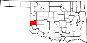 Beckham County map | |
| Towns | ||
| Unincorporated communities | ||
| Footnotes | ‡This populated place also has portions in an adjacent county or counties | |