Hihifo District
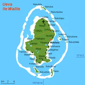
Hihifo (Uvean for "West") is one of the 5 districts of Wallis and Futuna, located in Wallis Island, in the Pacific Ocean. It is part of the Chiefdom of ʻUvea.
Hihifo | |
|---|---|
District | |
 Map of Wallis Island showing the 3 districts: Hihifo is located in the north | |
| Coordinates: 13°13′35″S 176°11′15″W | |
| Country | |
| Territory | |
| Island | Wallis |
| Chiefdom | ʻUvea |
| Capital | Vaitupu |
| Area | |
| • Total | 23.4 km2 (9.0 sq mi) |
| Population (2018) | |
| • Total | 1,942 |
| Time zone | UTC+12 |
| No. of municipalities | 5 |
Geography
Located in the northern side of the island, Hihifo borders with the districts of Hahake. Vaitupu is the administrative seat.
The district is divided into 5 municipal villages:[1]
| Village | Population |
|---|---|
| Alele | 524 |
| Vaitupu | 406 |
| Mala'e | 504 |
| Vailala | 341 |
| Tufuone | 167 |
Climate
Hihifo has a tropical rainforest climate (Köppen climate classification Af). The average annual temperature in Hihifo is 27.6 °C (81.7 °F). The average annual rainfall is 3,278.7 mm (129.08 in) with January as the wettest month. The temperatures are highest on average in April, at around 28.0 °C (82.4 °F), and lowest in July, at around 27.0 °C (80.6 °F). The highest temperature ever recorded in Hihifo was 33.4 °C (92.1 °F) on 29 April 2004; the coldest temperature ever recorded was 18.0 °C (64.4 °F) on 14 July 2014.
| Climate data for Hihifo (1991–2020 averages, extremes 1971−present) | |||||||||||||
|---|---|---|---|---|---|---|---|---|---|---|---|---|---|
| Month | Jan | Feb | Mar | Apr | May | Jun | Jul | Aug | Sep | Oct | Nov | Dec | Year |
| Record high °C (°F) | 33.0 (91.4) |
33.0 (91.4) |
32.8 (91.0) |
33.4 (92.1) |
32.8 (91.0) |
32.1 (89.8) |
31.4 (88.5) |
31.5 (88.7) |
32.0 (89.6) |
31.9 (89.4) |
33.1 (91.6) |
32.7 (90.9) |
33.4 (92.1) |
| Average high °C (°F) | 30.7 (87.3) |
30.8 (87.4) |
30.9 (87.6) |
30.8 (87.4) |
30.4 (86.7) |
29.8 (85.6) |
29.4 (84.9) |
29.6 (85.3) |
29.9 (85.8) |
30.1 (86.2) |
30.5 (86.9) |
30.7 (87.3) |
30.3 (86.5) |
| Daily mean °C (°F) | 27.9 (82.2) |
27.9 (82.2) |
27.9 (82.2) |
28.0 (82.4) |
27.7 (81.9) |
27.5 (81.5) |
27.0 (80.6) |
27.1 (80.8) |
27.3 (81.1) |
27.4 (81.3) |
27.6 (81.7) |
27.9 (82.2) |
27.6 (81.7) |
| Average low °C (°F) | 25.0 (77.0) |
25.0 (77.0) |
25.0 (77.0) |
25.1 (77.2) |
25.0 (77.0) |
25.1 (77.2) |
24.6 (76.3) |
24.6 (76.3) |
24.8 (76.6) |
24.7 (76.5) |
24.8 (76.6) |
25.0 (77.0) |
24.9 (76.8) |
| Record low °C (°F) | 19.9 (67.8) |
20.5 (68.9) |
19.6 (67.3) |
19.3 (66.7) |
18.5 (65.3) |
19.7 (67.5) |
18.0 (64.4) |
18.4 (65.1) |
19.2 (66.6) |
19.5 (67.1) |
20.5 (68.9) |
19.5 (67.1) |
18.0 (64.4) |
| Average precipitation mm (inches) | 395.2 (15.56) |
332.1 (13.07) |
309.3 (12.18) |
289.1 (11.38) |
223.8 (8.81) |
179.7 (7.07) |
213.4 (8.40) |
165.3 (6.51) |
219.8 (8.65) |
297.8 (11.72) |
306.2 (12.06) |
347.0 (13.66) |
3,278.7 (129.08) |
| Average precipitation days (≥ 1.0 mm) | 20.2 | 18.1 | 19.3 | 17.4 | 16.7 | 14.8 | 15.6 | 14.5 | 15.4 | 17.7 | 18.0 | 19.9 | 207.6 |
| Mean monthly sunshine hours | 170.9 | 161.4 | 175.4 | 185.9 | 180.8 | 167.9 | 179.8 | 192.5 | 191.0 | 187.4 | 181.6 | 175.2 | 2,149.9 |
| Source: Météo France[2] | |||||||||||||
See also
References
- "Population municipale des villages des îles Wallis et Futuna (recensement 2018)". INSEE. Retrieved 21 February 2020.
- "Climate of Hihifo 1991-2020" (PDF) (in French). Météo-France. Retrieved August 25, 2022.
External links
- Google (4 September 2013). "Hihifo District" (Map). Google Maps. Google. Retrieved 4 September 2013.
