Himeji
Himeji (姫路市, Himeji-shi) is a city located in Hyōgo Prefecture in the Kansai region of Japan. As of 1 June 2022, the city had an estimated population of 525,682 in 227,099 households and a population density of 980 persons per km².[1] The total area of the city is 534.35 square kilometres (206.31 sq mi).[1]
Himeji
姫路市 | |
|---|---|
 | |
 Flag  Emblem | |
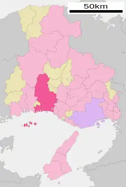 Location of Himeji in Hyōgo Prefecture | |
 Himeji Location in Japan | |
| Coordinates: 34°49′N 134°41′E | |
| Country | Japan |
| Region | Kansai |
| Prefecture | Hyōgo |
| Government | |
| • Mayor | Hideyasu Kiyomoto (from April 2019) |
| Area | |
| • Total | 534.35 km2 (206.31 sq mi) |
| Population (June 1, 2022) | |
| • Total | 525,682 |
| • Density | 980/km2 (2,500/sq mi) |
| Time zone | UTC+09:00 (JST) |
| City hall address | 4-1 Yasuda, Himeji-shi, Hyōgo-ken 670-8501 |
| Climate | Cfa |
| Website | Official website |
| Symbols | |
| Bird | White Heron |
| Flower | Pecteilis radiata |
| Tree | Evergreen Oak |

Geography
Himeji is located in the central western part of the Harima Plain in the western part of Hyogo Prefecture, and is the central city of the Harima region of the prefecture. The Ichikawa River is located in the central eastern part of the city, and the Senba River and Noda River are located in the center. The Ieshima Islands in the Seto Inland Sea are within the city limits and are located off the coast of Harima Bay. The city is surrounded by the mountains and the sea.
Neighbouring municipalities
Hyōgo Prefecture
Climate
Himeji has a humid subtropical climate (Köppen climate classification Cfa) with hot summers and cool winters. Summers are significantly wetter than winters. The average annual temperature in Himeji is 15.6 °C (60.1 °F). The average annual rainfall is 1,254.7 mm (49.40 in) with July as the wettest month. The temperatures are highest on average in August, at around 27.8 °C (82.0 °F), and lowest in January, at around 4.4 °C (39.9 °F).[2] The highest temperature ever recorded in Himeji was 38.0 °C (100.4 °F) on 31 August 2020; the coldest temperature ever recorded was −10.0 °C (14.0 °F) on 24 January 1963.[3]
| Climate data for Himeji (1991−2020 normals, extremes 1948−present) | |||||||||||||
|---|---|---|---|---|---|---|---|---|---|---|---|---|---|
| Month | Jan | Feb | Mar | Apr | May | Jun | Jul | Aug | Sep | Oct | Nov | Dec | Year |
| Record high °C (°F) | 17.5 (63.5) |
21.6 (70.9) |
23.3 (73.9) |
28.0 (82.4) |
31.8 (89.2) |
34.9 (94.8) |
37.3 (99.1) |
38.0 (100.4) |
36.6 (97.9) |
31.8 (89.2) |
26.4 (79.5) |
21.5 (70.7) |
38.0 (100.4) |
| Average high °C (°F) | 9.6 (49.3) |
10.4 (50.7) |
13.8 (56.8) |
19.1 (66.4) |
23.7 (74.7) |
26.8 (80.2) |
30.5 (86.9) |
32.5 (90.5) |
28.6 (83.5) |
23.1 (73.6) |
17.3 (63.1) |
11.9 (53.4) |
20.6 (69.1) |
| Daily mean °C (°F) | 4.4 (39.9) |
5.0 (41.0) |
8.3 (46.9) |
13.6 (56.5) |
18.5 (65.3) |
22.4 (72.3) |
26.4 (79.5) |
27.8 (82.0) |
23.8 (74.8) |
17.9 (64.2) |
11.9 (53.4) |
6.6 (43.9) |
15.6 (60.0) |
| Average low °C (°F) | 0.2 (32.4) |
0.5 (32.9) |
3.2 (37.8) |
8.2 (46.8) |
13.5 (56.3) |
18.5 (65.3) |
23.0 (73.4) |
24.0 (75.2) |
19.8 (67.6) |
13.4 (56.1) |
7.3 (45.1) |
2.4 (36.3) |
11.2 (52.1) |
| Record low °C (°F) | −10.0 (14.0) |
−7.8 (18.0) |
−7.6 (18.3) |
−2.0 (28.4) |
1.5 (34.7) |
7.9 (46.2) |
13.0 (55.4) |
14.3 (57.7) |
8.9 (48.0) |
1.7 (35.1) |
−2.0 (28.4) |
−7.4 (18.7) |
−10.0 (14.0) |
| Average precipitation mm (inches) | 36.9 (1.45) |
48.6 (1.91) |
92.0 (3.62) |
104.7 (4.12) |
127.3 (5.01) |
160.4 (6.31) |
184.3 (7.26) |
105.4 (4.15) |
177.8 (7.00) |
108.7 (4.28) |
61.2 (2.41) |
47.5 (1.87) |
1,254.7 (49.40) |
| Average snowfall cm (inches) | 1 (0.4) |
4 (1.6) |
0 (0) |
0 (0) |
0 (0) |
0 (0) |
0 (0) |
0 (0) |
0 (0) |
0 (0) |
0 (0) |
1 (0.4) |
6 (2.4) |
| Average precipitation days (≥ 1.0 mm) | 4.7 | 6.0 | 8.7 | 8.8 | 9.0 | 10.8 | 10.3 | 7.0 | 9.3 | 7.5 | 5.5 | 5.3 | 92.9 |
| Average snowy days (≥ 1 cm) | 0.3 | 0.8 | 0 | 0 | 0 | 0 | 0 | 0 | 0 | 0 | 0 | 0.4 | 1.5 |
| Average relative humidity (%) | 70 | 69 | 67 | 66 | 70 | 75 | 78 | 73 | 74 | 73 | 73 | 72 | 72 |
| Mean monthly sunshine hours | 149.1 | 142.5 | 173.7 | 191.8 | 203.1 | 156.0 | 172.1 | 209.9 | 158.8 | 167.4 | 154.8 | 155.1 | 2,034.4 |
| Source: Japan Meteorological Agency[3][2] | |||||||||||||
Demographics
Per Japanese census data, the population of Himeji in 2020 is 530,495 people.[4] Himeji has been conducting censuses since 1920.
| Year | Pop. | ±% |
|---|---|---|
| 1920 | 209,208 | — |
| 1925 | 221,240 | +5.8% |
| 1930 | 232,805 | +5.2% |
| 1935 | 244,556 | +5.0% |
| 1940 | 270,719 | +10.7% |
| 1945 | 308,321 | +13.9% |
| 1950 | 325,329 | +5.5% |
| 1955 | 348,365 | +7.1% |
| 1960 | 372,824 | +7.0% |
| 1965 | 412,507 | +10.6% |
| 1970 | 447,666 | +8.5% |
| 1975 | 479,360 | +7.1% |
| 1980 | 494,825 | +3.2% |
| 1985 | 506,101 | +2.3% |
| 1990 | 509,129 | +0.6% |
| 1995 | 527,854 | +3.7% |
| 2000 | 534,969 | +1.3% |
| 2005 | 536,232 | +0.2% |
| 2010 | 536,338 | +0.0% |
| 2015 | 535,664 | −0.1% |
| 2020 | 530,495 | −1.0% |
| Himeji population statistics[4] | ||
History
Himeji has been the center of Harima Province since the Nara period, and was the location of the provincial capital and Harima Kokubun-ji. After the Battle of Sekigahara, Ikeda Terumasa received a fief at Harima Province and established the Himeji Domain. He expanded Himeji Castle and its castle town. Due to its location dominating the San'yōdō highway connecting the Kinai region with western Japan, Himeji was a major stronghold of the Tokugawa shogunate through the Bakumatsu period. Following the Meiji restoration, Himeji was the capital of "Himeji Prefecture" (later Shikama Prefecture) from 1871, which was merged into Hyōgo Prefecture in 1876. The city of Himeji was established on April 1, 1889 with the creation of the modern municipalities system. After the 1923 Great Kantō earthquake, the Japanese government reportedly considered moving the nation's capital from Tokyo to Himeji. On April 1, 1996, Himeji attained Core city status, with increased local autonomy.
On March 27, 2006, the town of Yasutomi (from Shisō District), the town of Kōdera (from Kanzaki District), and the towns of Ieshima and Yumesaki (both from Shikama District) were merged into Himeji.
Air raids
During World War II, Himeji was a target for the United States' XXI Bomber Command as it was an important rail terminal and contained two large military zones. The first air raid occurred o June 22, 1945 at 0950, in which 60 B-29 Superfortress bombers centered on Andrea containing a Kawanishi Aircraft Company factory. The bombing killed 341 people and rendered 10,220 homeless. The second attack occurred on July 3, 1945 at 16:23, 107 aircraft dropped 767 tons of incendiary bombs on Himeji, destroying 63.3% of the built up areas of the city.[5] However, the famous Himeji Castle, although blackened by smoke from the burning city, remained unscathed, even with one firebomb being dropped on it.[6] This attack killed 173 people, severely wounded 160, and resulted in the destruction of 10,300 buildings, rendering 45,182 people homeless.
Government
Himeji has a mayor-council form of government with a directly elected mayor and a unicameral city council of 46 members. Himeji contributes eight members to the Hyogo Prefectural Assembly. In terms of national politics, the city is divided between the Hyōgo 11th and Hyōgo 12th districts of the lower house of the Diet of Japan.
Mayors of Himeji City (1889–Present)
|
| ||||||||||||||||||||||||||||||||||||||||||||||||||||||||||||||||||||||||||||||||||||||||||||||||||||||||||||||
Economy
Himeji is located within the Hanshin Industrial Area and Harima Seaside Industrial Areas. The coastal region is heavily industrialized, with steel mills, chemical plants, semiconductor and automobile electronics predominating. In addition, Kansai Electric Power's Himeji No. 1 Power Station and Himeji No. 2 Power Station are located in the area. The northern two-thirds of the city is mainly agricultural and commercial fishing off the southern seacoast also plays a role in the economy. Traditional crafts include the production of butsudan (Buddhist altars), leather crafts, glue, matchmaking and candles.
Education
Colleges and universities
- University of Hyogo - Himeji Institute of Technology
- Himeji University
- Himeji Dokkyo University
- Himeji Hinomoto College
- Kenmei Women's Junior College (1951–2008)
Primary and secondary schools
Himeji has 66 public elementary schools, 32 public middle schools and three public high schools operated by the city government and 13 public high schools operated by the Hyōgo Prefectural Department of Education. There are also four private combined middle/high schools. There are also four special education school for the handicapped, one operated by the city and three by the prefecture.
A North Korean school, Seiban North Korean Elementary and Middle School (西播朝鮮初中級学校), can also be found in the city.[7]
Transportation
Railway
![]() JR West – San'yō Main Line (JR Kobe Line)
JR West – San'yō Main Line (JR Kobe Line)
- Himeji-Bessho - Gochaku - Higashi-Himeji - Himeji --- Agaho - Harima-Katsuhara - Aboshi
- Himeji - Harima-Takaoka - Yobe - Ōichi
![]() Sanyo Electric Railway - Main Line
Sanyo Electric Railway - Main Line
- Ōshio - Matogata - Yaka - Shirahamanomiya - Mega - Shikama - Kameyama - Tegara - Sanyo Himeji
![]() Sanyo Electric Railway - Aboshi Line
Sanyo Electric Railway - Aboshi Line
- Shikama - Nishi-Shikama - Yumesakigawa - Hirohata - Sanyo-Temma - Hiramatsu - Sanyo-Aboshi
Highways
Ferries
- Shodoshima Ferry: Himeji Kazuma Port-Fukuda Port (Shōdoshima)
- Bozeki Kisen: Himeji Kazuma Port - Tanga Island - Boze Island
- Kosoku Ieshima: Himeji Kazuma Port - Iejima
- Takafuku Liner: Himeji Kazuma Port - Iejima
International relations
Himeji is twinned or has sister city relationships with six international cities and two Japanese cities, as well as a sister castle located in France. Himeji has a particularly strong relationship with Phoenix, as teachers from America are able to teach English abroad for 1–2 years. Additionally, the Youth Ambassador Exchange Program allows for both Japanese and American high school students to experience the cultures and languages of their respective countries for 3 weeks.[8]
International
.svg.png.webp) Charleroi, Belgium
Charleroi, Belgium Phoenix, Arizona, United States[9]
.svg.png.webp) Adelaide, South Australia, Australia
Adelaide, South Australia, Australia Curitiba, Paraná, Brazil
 Taiyuan, Shanxi, China
 Changwon, South Gyeongsang, South Korea
Japan
 Matsumoto, in Nagano Prefecture
 Tottori, capital city in Tottori Prefecture
Sister castles
 Château de Chantilly in Chantilly, France
 Conwy Castle (Castell Conwy) in North Wales, since October 2019[10]
Local attractions
- Himeji Castle, a UNESCO World Heritage Site. For over 400 years, Himeji Castle has remained intact, even throughout the extensive bombing of Himeji in World War II and natural disasters such as the 1995 Great Hanshin earthquake and various typhoons.[11][12][13]
- Engyō-ji temple
- Mount Seppiko
- Himeji Central Park (a safari park)
- Himeji City Tegarayama Botanical Garden
- Harima Kokubun-ji ruins, National Historic Site
- Koko-en Garden.
- Okishio Castle - A castle ruin, Home castle of the Akamatsu clan.

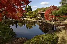
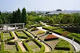 Tegarayama Central Park
Notable people from Himeji
- Kuroda Kanbei (黒田 官兵衛) (1546–1604), famed strategist under Toyotomi Hideyoshi
- Mikinosuke Kawaishi (川石 酒造之助) (1899–1969), judoka
- Aya Matsuura (松浦 亜弥) (1986-), entertainer
- Psycho le Cému (サイコ・ル・シェイム), visual kei rock band
- Kenzō Takada (高田 賢三) (1939-2020), fashion designer
- Tetsuro Watsuji (和辻 哲郎) (1889-1960), philosopher and historian
- Masahisa Takenaka (竹中 正久) (1933-1985), the 4th kumicho of Yamaguchi-gumi, Japan's largest Yakuza syndicate
References
- "Himeji city official statistics" (PDF) (in Japanese). Japan.
- 気象庁 / 平年値(年・月ごとの値). JMA. Retrieved April 11, 2022.
- 観測史上1~10位の値(年間を通じての値). JMA. Retrieved April 11, 2022.
- Himeji population statistics
- 21st Bomber Command Tactical Mission Report 247, 250, Ocr
- "David Millet".
- ウリハッキョ一覧. Chongryon. Archived from the original on December 19, 2015. Retrieved October 14, 2015..
- Sister Cities Archived 2014-07-12 at the Wayback Machine. City of Himeji. Retrieved August 24, 2008. (in Japanese)
- "Phoenix Sister Cities". Phoenix Sister Cities. Archived from the original on 2013-07-24. Retrieved 2013-08-06.
- "Conwy and Himeji castles' twinning starts "beautiful friendship"". BBC News. November 7, 2019.
- "A hilltop white heron 400 years old". The Daily Yomiuri. Retrieved July 5, 2010.
- "Himeji Castle starts its renovation in April". Official Tourism Guide for Japan Travel. Archived from the original on March 24, 2011. Retrieved July 1, 2010.
- "Himeji Castle". Japan Atlas. Retrieved July 5, 2010.
External links
- Himeji City official website (in Japanese)
- Official tourism website (in English)
 Geographic data related to Himeji at OpenStreetMap