Hinterrhein District
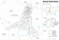
Hinterrhein District is a former administrative district in the canton of Graubünden, Switzerland. It had an area of 617.67 km2 (238.48 sq mi) and had a population of 13,179 in 2015. Much of the district became part of the Viamala Region on 1 January 2017 as part of a reorganization of the Canton.[1]
Hinterrhein District
Bezirk Hinterrhein District dal Rain Posteriur | |
|---|---|
District | |
 | |
| Country | |
| Canton | |
| Capital | Thusis |
| Area | |
| • Total | 617.63 km2 (238.47 sq mi) |
| Population (2020) | |
| • Total | 13,179 |
| • Density | 21/km2 (55/sq mi) |
| Time zone | UTC+1 (CET) |
| • Summer (DST) | UTC+2 (CEST) |
| Municipalities | 24 |
Hinterrhein District consisted of five Kreise (sub-districts) and twenty-four municipalities. This number decreased from thirty-two when the municipalities of Portein, Präz, Sarn, and Tartar merged on 1 January 2010 into Cazis.[2] It decreased further in 2015 when Almens, Paspels, Pratval, Rodels and Tomils merged to form the new municipality of Domleschg.[2]
| Avers sub-district | ||||
|---|---|---|---|---|
| Municipality | Population (31 December 2020)[3] |
Area (km²) | ||
| Avers | 164 | 93.07 | ||
| Domleschg sub-district | ||||
|---|---|---|---|---|
| Municipality | Population (31 December 2020)[3] |
Area (km²) | ||
| Domleschg | 2,160 | 45.94 | ||
| Fürstenau | 350 | 1.30 | ||
| Rothenbrunnen | 304 | 3.10 | ||
| Scharans | 796 | 14.28 | ||
| Sils im Domleschg | 971 | 9.32 | ||
| Rheinwald sub-district | ||||
|---|---|---|---|---|
| Municipality | Population (31 December 2020)[3] |
Area (km²) | ||
| Hinterrhein | 61 | 48.38 | ||
| Nufenen | 139 | 28.07 | ||
| Splügen | 377 | 60.53 | ||
| Sufers | 146 | 34.56 | ||
| Schams sub-district | ||||
|---|---|---|---|---|
| Municipality | Population (31 December 2020)[3] |
Area (km²) | ||
| Andeer | 916 | 30.46 | ||
| Casti-Wergenstein | 56 | 25.59 | ||
| Donat | 203 | 4.67 | ||
| Ferrera | 79 | 75.46 | ||
| Lohn | 51 | 8.14 | ||
| Mathon | 53 | 15.12 | ||
| Rongellen | 56 | 2.04 | ||
| Zillis-Reischen | 389 | 24.46 | ||
| Thusis sub-district | ||||
|---|---|---|---|---|
| Municipality | Population (31 December 2020)[3] |
Area (km²) | ||
| Cazis | 2,287 | 31.2a | ||
| Flerden | 247 | 6.06 | ||
| Masein | 500 | 4.19 | ||
| Thusis | 9,453 | 6.84 | ||
| Tschappina | 134 | 24.67 | ||
| Urmein | 150 | 4.35 | ||
Mergers
- On 1 January 2003 the municipalities of Donath and Patzen-Fardün became part of Donat.
- On 1 January 2006 Medels im Rheinwald became part of Splügen.
- On 1 January 2009 Tomils was created through the merger of Feldis/Veulden, Scheid, Trans and Tumegl/Tomils.
- On 1 January 2010 Portein, Präz, Sarn and Tartar merged into Cazis.
- On 1 January 2015 Almens, Paspels, Pratval, Rodels and Tomils merged to form Domleschg.
Languages
| Languages of Hinterrhein District, GR | ||||||
| Languages | Census 2000 | |||||
| Number | Percent | |||||
| German | 10,909 | 85.5% | ||||
| Romansh | 728 | 5.7% | ||||
| Italian | 301 | 2.4% | ||||
| TOTAL | 12,758 | 100% | ||||
References
- Swiss Federal Statistical Office - Amtliches Gemeindeverzeichnis der Schweiz - Mutationsmeldungen 2016 accessed 16 February 2017
- Amtliches Gemeindeverzeichnis der Schweiz published by the Swiss Federal Statistical Office (in German) accessed 2 January 2013
- "Ständige und nichtständige Wohnbevölkerung nach institutionellen Gliederungen, Geburtsort und Staatsangehörigkeit". bfs.admin.ch (in German). Swiss Federal Statistical Office - STAT-TAB. 31 December 2020. Retrieved 21 September 2021.
This article is issued from Wikipedia. The text is licensed under Creative Commons - Attribution - Sharealike. Additional terms may apply for the media files.