Homewood, Pennsylvania
Homewood is a borough that is located in northern Beaver County, Pennsylvania, United States. The population was 104 at the time of the 2020 census.[3]
Homewood, Pennsylvania | |
|---|---|
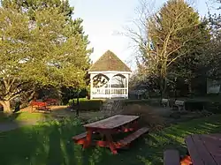
 Old Homewood Park | |
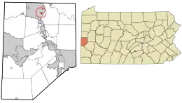
 Location in Beaver County and the U.S. state of Pennsylvania. | |
| Coordinates: 40°48′50″N 80°19′47″W | |
| Country | United States |
| State | Pennsylvania |
| County | Beaver |
| Settled | 1859 |
| Incorporated | 1910 |
| Government | |
| • Type | Borough Council |
| Area | |
| • Total | 0.17 sq mi (0.44 km2) |
| • Land | 0.17 sq mi (0.44 km2) |
| • Water | 0.00 sq mi (0.00 km2) |
| Elevation | 971 ft (296 m) |
| Population | |
| • Total | 104 |
| • Density | 615.38/sq mi (236.99/km2) |
| Time zone | UTC-5 (Eastern (EST)) |
| • Summer (DST) | UTC-4 (EDT) |
| Zip code | 15208 |
| Area code | 724 |
| FIPS code | 42-35488 |
It is part of the Pittsburgh metropolitan area.
Geography

Homewood is located in northern Beaver County at 40°48′50″N 80°19′47″W (40.813995, −80.329852).[4] It is entirely surrounded by the borough of Big Beaver.
The Pennsylvania Turnpike (Interstate 76) passes through the northeast corner of the borough, with Exit 13 (Pennsylvania Route 18/Big Beaver Boulevard) located just outside the borough limits. PA-18 runs through the eastern edge of the borough.
According to the United States Census Bureau, the borough has a total area of 0.17 square miles (0.44 km2), all land.[5]
The borough has a waterfall within the community, which was named Buttermilk Falls in the year 1870. The waters fall into a natural basin of solid sandstone. The town lends its name to the Homewood Formation, the sandstone rock layer which is exposed at Buttermilk Falls. The Homewood Formation is the upper member of the Pottsville Group (Wanless, 1939).
Homewood is drained by Clarks Run, which flows into the Beaver River a short distance to the east.
Demographics
| Census | Pop. | Note | %± |
|---|---|---|---|
| 1880 | 267 | — | |
| 1920 | 310 | — | |
| 1930 | 343 | 10.6% | |
| 1940 | 357 | 4.1% | |
| 1950 | 316 | −11.5% | |
| 1960 | 305 | −3.5% | |
| 1970 | 212 | −30.5% | |
| 1980 | 188 | −11.3% | |
| 1990 | 162 | −13.8% | |
| 2000 | 147 | −9.3% | |
| 2010 | 109 | −25.9% | |
| 2020 | 104 | −4.6% | |
| 2021 (est.) | 103 | [3] | −1.0% |
| Sources:[6][7][8][2] | |||
As of the 2000 census,[7] there were 147 people, 59 households, and 37 families residing in the borough.
The population density was 855.1 inhabitants per square mile (330.2/km2). There were sixty-two housing units at an average density of 360.7 per square mile (139.3/km2).
The racial makeup of the borough was 94.56% White, 2.04% African American, and 3.40% Native American.
There were fifty-nine households, out of which 15.3% had children under the age of eighteen living with them; 47.5% were married couples living together, 10.2% had a female householder with no husband present, and 35.6% were non-families. 28.8% of all households were made up of individuals, and 8.5% had someone living alone who was sixty-five years of age or older.
The average household size was 2.49 and the average family size was 3.08.
In the borough, the population was spread out, with 15.0% under the age of eighteen, 13.6% from eighteen to twenty-four, 26.5% from twenty-five to forty-four, 27.9% from forty-five to sixty-four, and 17.0% who were sixty-five years of age or older. The median age was forty-two years.
For every one hundred females, there were 96.0 males. For every one hundred females who were aged eighteen or older, there were 101.6 males.
The median income for a household in the borough was $33,333, and the median income for a family was $52,500. Males had a median income of $31,250 compared with that of $20,357 for females.
The per capita income for the borough was $34,486.
There were 4.5% of families and 9.0% of the population living below the poverty line, including 16.0% of those who were aged sixty-four or older; however, no one aged eighteen or under was living in poverty.
Education
Children in Homewood are served by the Big Beaver Falls Area School District. The current schools serving Homewood are:
- Big Beaver Elementary School – grades K–5
- Beaver Falls Middle School – grades 6–8
- Beaver Falls High School – grades 9–12
References
- "ArcGIS REST Services Directory". United States Census Bureau. Retrieved October 12, 2022.
- "Census Population API". United States Census Bureau. Retrieved October 12, 2022.
- Bureau, US Census. "City and Town Population Totals: 2020-2021". Census.gov. US Census Bureau. Retrieved July 19, 2022.
- "US Gazetteer files: 2010, 2000, and 1990". United States Census Bureau. February 12, 2011. Retrieved April 23, 2011.
- "Geographic Identifiers: 2010 Demographic Profile Data (G001): Homewood borough, Allegheny County, Pennsylvania". U.S. Census Bureau, American Factfinder. Archived from the original on February 12, 2020. Retrieved February 24, 2014.
- "Census of Population and Housing". U.S. Census Bureau. Retrieved December 11, 2013.
- "U.S. Census website". United States Census Bureau. Retrieved January 31, 2008.
- "Incorporated Places and Minor Civil Divisions Datasets: Subcounty Resident Population Estimates: April 1, 2010 to July 1, 2012". Population Estimates. U.S. Census Bureau. Archived from the original on June 11, 2013. Retrieved December 11, 2013.
