Hongshunli Subdistrict
Hongshunli Subdistrict (simplified Chinese: 鸿顺里街道; traditional Chinese: 鴻順裏街道; pinyin: Hóngshùnlǐ Jiēdào) is a subdistrict located within Hebei District, Tianjin, China. It shares border with Xinkaihe and Tiedong Road Subdistricts in the northwest, Ningyuan Subdistrict in the northeast, Wanghailou Subdistrict in the southeast, Santiaoshi and Dahutong Subdistircts in the southwest. In the year 2010, its population was 94,411.[1]
Hongshunli Subdistrict
鸿顺里街道 | |
|---|---|
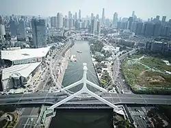
 Aerial view of Tianjin Eye, 2019 | |
.png.webp) Location within Hebei District | |
 Hongshunli Subdistrict  Hongshunli Subdistrict | |
| Coordinates: 39°09′26″N 117°11′20″E | |
| Country | China |
| Municipality | Tianjin |
| District | Hebei |
| Village-level Divisions | 11 communities |
| Area | |
| • Total | 2.67 km2 (1.03 sq mi) |
| Elevation | 7 m (23 ft) |
| Population (2010) | |
| • Total | 94,411 |
| • Density | 35,000/km2 (92,000/sq mi) |
| Time zone | UTC+8 (China Standard) |
| Postal code | 300141 |
| Area code | 022 |
Its name Hongshunli can be literally translated as "Great Success Neighborhood".[2]
Geography
Hongshunli subdistrict is on the east of Hai River and southeast of Xinkai River. Waihuan East Road passes through the northeast of the subdistrict.
History
| Year | Status | Part of |
|---|---|---|
| 1949 - 1952 | Hongshunli Street | 2nd District, Tianjin |
| 1952 - 1954 | 3rd District, Tianjin | |
| 1954 - 1956 | Hongshunli Subdistrict | |
| 1956 - 1958 | Hebei District, Tianjin | |
| 1958 - 1962 | Hongshunli Urban People's Commune | |
| 1962 - 1966 | Hongshunli Subdistrict | |
| 1966 - 1968 | Weidong District, Tianjin | |
| 1968 - 1978 | Hongshunli Revolutionary Committee | Hebei District, Tianjin |
| 1978 - present | Hongshunli Subdistrict (Huangwei Road Subdistrict was added in 1990; Zhongshan Road Subdistrict in 2000) |
Administrative divisions
The table below lists all the 11 residential communities under Hongshunli Subdistrict in 2021:[3]
| Subdivision Names | Name Transliterations |
|---|---|
| 六马路 | Liumalu |
| 律纬路 | Lüweilu |
| 月纬路 | Yueweilu |
| 律笛里 | Lüdili |
| 日远里 | Riyuanli |
| 鸿顺里 | Hongshunli |
| 团结里 | Tuanjieli |
| 元吉里 | Yuanjili |
| 九八三 | Jiubasan |
| 宝兴里 | Baoxingli |
| 三戒里 | Sanjieli |
Landmarks
Gallery
 Fulun Middle School, 2014
 Historical Structure in Sanma Road, 2014
.jpg.webp) Night view of Hai River near Hongshunli Subdistrict, 2016
Night view of Hai River near Hongshunli Subdistrict, 2016 Skyline of Hongshunli, 2017
References
- "China: Tiānjīn Municipal Province (Districts and Townships) - Population Statistics, Charts and Map". www.citypopulation.de. Retrieved 2022-11-05.
- 中华人民共和国政区大典:天津市卷 (in Chinese). 中国社会出版社. 2020.
- "2021年统计用区划代码和城乡划分代码". www.stats.gov.cn. Retrieved 2022-11-23.