Hoyt, Oklahoma
Hoyt is an unincorporated community and census-designated place (CDP) in Haskell County, Oklahoma, United States.[2] The community is 3.9 miles (6.3 km) west-northwest of Whitefield. A post office was established at Hoyt, Indian Territory on August 19, 1890. It was named for Babe Hoyt, a local ferryboat operator.[3] The post office closed on April 17, 2004; it still has its own ZIP code, 74440.[4][5]
Hoyt, Oklahoma | |
|---|---|
 Hoyt  Hoyt | |
| Coordinates: 35°16′05″N 95°18′01″W | |
| Country | United States |
| State | Oklahoma |
| County | Haskell |
| Area | |
| • Total | 0.97 sq mi (2.52 km2) |
| • Land | 0.97 sq mi (2.52 km2) |
| • Water | 0.00 sq mi (0.01 km2) |
| Elevation | 568 ft (173 m) |
| Population (2020) | |
| • Total | 82 |
| • Density | 84.45/sq mi (32.60/km2) |
| Time zone | UTC-6 (Central (CST)) |
| • Summer (DST) | UTC-5 (CDT) |
| ZIP code | 74440 |
| Area code(s) | 918 & 539 |
| GNIS feature ID | 2629922[2] |
It is home to the Hoyt School, which is no longer in use, but has been nominated for classification as an official Oklahoma landmark.[6]
At the time of its founding, Hoyt was located in the Moshulatubbee District of the Choctaw Nation.[7]
References
- "ArcGIS REST Services Directory". United States Census Bureau. Retrieved September 20, 2022.
- U.S. Geological Survey Geographic Names Information System: Hoyt, Oklahoma
- Shirk, George H. Oklahoma Place Names (Norman: University of Oklahoma Press, 1965), p. 107.
- United States Postal Service. "USPS - Look Up a ZIP Code". Retrieved January 23, 2016.
- "Postmaster Finder - Post Offices by ZIP Code". United States Postal Service. Retrieved January 23, 2016.
- "Oklahoma Landmarks Nomination Inventory" (PDF). Government of the State of Oklahoma. Retrieved January 23, 2016.
- Morris, John W. Historical Atlas of Oklahoma (Norman: University of Oklahoma Press, 1986), plate 38.
- "Census of Population and Housing". Census.gov. Retrieved June 4, 2016.
Municipalities and communities of Haskell County, Oklahoma, United States | ||
|---|---|---|
| City | 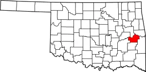 Haskell County map | |
| Towns | ||
| CDPs | ||
| Indian reservation | ||
| Footnotes | ‡This populated place also has portions in another county or counties | |
This article is issued from Wikipedia. The text is licensed under Creative Commons - Attribution - Sharealike. Additional terms may apply for the media files.