Humphreys, Oklahoma
Humphreys is an unincorporated community in southeast Jackson County, Oklahoma, United States.[1] It is located 7.5 miles southeast of Altus and six miles northeast of Tipton in adjacent Tillman County.[2][3] The old Missouri–Kansas–Texas Railroad passes through the community.[4] The community was founded in 1909 and named after a local rancher, James Humphreys.[3]
Humphreys, Oklahoma | |
|---|---|
 Humphreys  Humphreys | |
| Coordinates: 34°33′21″N 99°14′14″W | |
| Country | United States |
| State | Oklahoma |
| County | Jackson |
| Elevation | 1,286 ft (392 m) |
| Time zone | UTC-6 (Central (CST)) |
| • Summer (DST) | UTC-5 (CDT) |
| Area code | 580 |
| GNIS feature ID | 1094017[1] |
References
- U.S. Geological Survey Geographic Names Information System: Humphreys, Oklahoma
- Oklahoma Atlas & Gazetteer, DeLorme, 1st ed., 1998, p. 49 ISBN 0899332838
- Shirk, George H. Oklahoma Place Names, Norman, Oklahoma: University of Oklahoma Press, 2nd ed., 1987, p.121.
- Tipton, OK, 7.5 Minute Topographic Quadrangle, USGS, 1964 (1978 rev.)
Municipalities and communities of Jackson County, Oklahoma, United States | ||
|---|---|---|
| City | 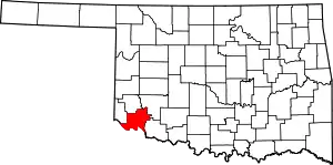 Jackson County map | |
| Towns | ||
| Unincorporated communities | ||
| Ghost towns | ||
This article is issued from Wikipedia. The text is licensed under Creative Commons - Attribution - Sharealike. Additional terms may apply for the media files.