Humuya
Humuya (Spanish pronunciation: [uˈmuʝa]) is a municipality in the Honduran department of Comayagua.
Humuya | |
|---|---|
Municipality | |
 Humuya | |
| Coordinates: 14°15′N 87°40′W | |
| Country | |
| Departament | Comayagua |
| Area | |
| • Total | 54 km2 (21 sq mi) |
| Population (2015) | |
| • Total | 1,358 |
| • Density | 25/km2 (65/sq mi) |
Total area of Humuya is 5,300 hectares 53.00 km² (20.46 sq mi) with tropical savanna climate, its altitude is 641 m (2,103 ft) above sea level.
Humuya geographical coordinates: Latitude: 14.25, Longitude: -87.6667 14° 15′ 0″ North, 87° 40′ 0″ West[1]
In Humuya, the peak fire season typically begins in late March and finishes in June (lasts around 3 month). From 2001 to 2021, Humuya has lost 14ha of tree cover due to fires and 130ha from all other drivers of loss.[2]
Capital: Comayagua | ||
| Municipalities | 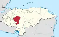 | |
References
- "Humuya, Comayagua, Honduras - City, Town and Village of the world". en.db-city.com. Retrieved 2022-10-02.
- Vizzuality. "Humuya, Comayagua, Honduras Deforestation Rates & Statistics | GFW". www.globalforestwatch.org. Retrieved 2022-10-03.
This article is issued from Wikipedia. The text is licensed under Creative Commons - Attribution - Sharealike. Additional terms may apply for the media files.