Hurricane Ismael (1989)
Hurricane Ismael was a strong tropical cyclone that resulted in heavy rains and flash floods across portions of Mexico during mid-August 1989. The ninth named storm, fifth hurricane and the first major hurricane of the very active 1989 Pacific hurricane season, Ismael formed from a tropical wave that traversed Central America on August 11.
| Category 3 major hurricane (SSHWS/NWS) | |
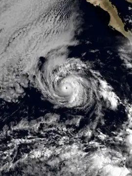
 Hurricane Ismael near its peak intensity on August 19 | |
| Formed | August 14, 1989 |
|---|---|
| Dissipated | August 25, 1989 |
| Highest winds | 1-minute sustained: 120 mph (195 km/h) |
| Lowest pressure | 955 mbar (hPa); 28.2 inHg |
| Fatalities | 3 total |
| Damage | None |
| Areas affected | Mexico |
| Part of the 1989 Pacific hurricane season | |
The tropical wave that formed Ismael formed off the coast of northwestern Africa on July 31. After traversing off Central America without any activity, the trough developed deep convection and developed into Tropical Depression Eleven-E on August 14 and into Tropical Storm Ismael on August 15, just one day later.
After producing downpours of rain killing 3, Ismael turned westward and for the next week, would be controlled by a high-pressured area. Along the way, Ismael interacted with a tropical wave, which spawned Tropical Storm Juliette.The hostile and cold water and an increase in wind shear would take its toll on Ismael as it went from a Category 2 storm to a tropical storm on August 23. Ismael would weaken to a tropical depression and soon dissipated with its remnants headed towards Hawaii. The remnants soon dispersed as they headed towards Hawaii.
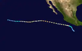
Meteorological history

Tropical storm (39–73 mph, 63–118 km/h)
Category 1 (74–95 mph, 119–153 km/h)
Category 2 (96–110 mph, 154–177 km/h)
Category 3 (111–129 mph, 178–208 km/h)
Category 4 (130–156 mph, 209–251 km/h)
Category 5 (≥157 mph, ≥252 km/h)
Unknown
Traces of Hurricane Ismael can be found from a tropical wave that emerged off of northwestern Africa back on July 31.[1] The trough passed through the Atlantic and Caribbean without any event. After passing through Central America without any significant convection or organization, the trough entered the Intertropical Convergence Zone (ITCZ) on August 11.[2]
Three days later, after moving westward, the system began to better organize while still being off the coast of Mexico.[1] After significant increase in convection and organization, and satellite animation showing an organized upper-level outflow, the trough intensified to Tropical Depression Eleven-E on August 14.[1][3][4]
Just a day later, on August 15, Eleven-E had winds up to 35 mph with a barometric pressure of 1004 mbar and had intensified into a tropical storm based on the Dvorak technique. Eleven-E was designated as Tropical Storm Ismael on 8:30 UTC.[2] Ismael had developed rainbands which helped contribute to finding intensity.[2]
Ismael had produced heavy rain from Acapulco to the Sierra Madre del Sur Mountains as it skirted along the coast of Guerrero.[5][6] Flash floods and mudslides had also occurred in the area.[6] 3 deaths had also occurred in the area.[7] On August 16, Ismael quickly intensified into a hurricane as it formed a visible eye at 8:30 UTC with winds up to 75 knots. Ismael had maintained a westerly course towards the Hawaiian Islands through the rest of its lifetime.
The system had intensified to Category 2 status at 12:00 UTC on August 17 with maximum sustained winds of 90 knots (100 mph).[4][8][9] Ismael weakened back to Category 1 status at 06:00 UTC, but two days later, reached its peak of 105 knots (121 mph) and reached Category 3 status at 18:00 UTC.[10][11][4] The eye of Ismael was clouded and soon, went through a period of degenerating after moving into colder waters.[10] While Ismael continued on its westward course, the system made contact with another tropical wave which eventually led to the formation of Tropical Storm Twelve-E. A few days later, the system intensified into Tropical Storm Juliette. Although going through a point of degeneration, Ismael still continued to show deep convection with winds of 75 knots (86 mph) on September 21.[12]
Ismael had intensified back to Category 2 status with 95 knots (109 mph) maximum sustained winds at 18:00 UTC the next day and continued a trend with rising and falling speeds. From August 23 – 24, Ismael had experienced rapid weakening.[13] The system went from a Category 2 hurricane to a tropical storm in a day.[9][13] A sign of weakening from Ismael was an open vortex. Deep convection had decreased and an entry into cooler waters deteriorated Ismael's structure as well.[13] Ismael had degenerated into a tropical depression and soon, a remnant on the 25 of August. The remnants of Ismael headed towards Hawaii, but the government of Hawaii did not put any warnings.[9] The remnants dispersed on August 26.[9]
Impact
Although Hurricane Ismael did not make landfall, it did impact Mexico with rainfall from its rain bands. Ismael also killed 3 people while intensifying into a hurricane. One person by the name of Rhonda Santos was swept by Ismael's 8-foot waves and drowned off of Laguna Beach, in California.[14] The storm was 450 miles off the coast of San Diego, California. Two other people had also died from drowning due to Ismael's waves.[7] The system also brought heavy rains to Acapulco. Not much else was recorded.
See also
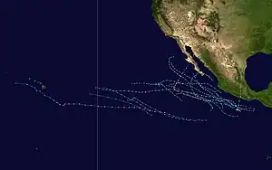
- 1989 Pacific hurricane season
- Tropical Storm Juliette (1989) – Ismael contributed to Juliette's formation
- Hurricane Ismael and other uses of Ismael for hurricane names.
References
- Max Mayfield (August 14, 1989). "Tropical Depression Eleven-E Discussion 1". National Hurricane Center. Retrieved May 16, 2010.
- Mayfield, Max (July 24, 1996). "Tropical Cyclone Discussion Tropical Storm Ismael (5)". National Oceanic and Atmospheric Administration. Retrieved March 29, 2021.
- Scientific and Technical Aerospace Reports. Scientific and Technical Information Office, National Aeronautics and Space Administration. 1990.
- "Major Hurricane Ismael (12E) - 1989". tropicaleastpacific.com. Retrieved 2021-03-26.
- Mayfield, Max (July 24, 1997). "PRELIMINARY REPORT Hurricane Ismael". National Oceanic and Atmospheric Administration. Retrieved March 29, 2021.
- "The Spokesman-Review - Google News Archive Search". news.google.com. Retrieved 2021-03-29.
- Lawrence, Miles B. (1990-05-01). "Eastern North Pacific Hurricane Season of 1989". Monthly Weather Review. 118 (5): 1186–1193. Bibcode:1990MWRv..118.1186L. doi:10.1175/1520-0493(1990)118<1186:ENPHSO>2.0.CO;2. ISSN 1520-0493.
- "HURRICANE ISMAEL ADVISORY NUMBER 11". National Oceanic and Atmospheric Administration. July 24, 1997. Retrieved March 29, 2021.
- Diagnostic Report of the National Hurricane Center. The Center. 1989.
- "Tropical Cyclone Discussion Hurricane Ismael (27)". July 24, 1997.
- "Tropical Cyclone Discussion Hurricane Ismael (21)". National Oceanic and Atmospheric Administration. July 24, 1997. Retrieved March 29, 2021.
- "Tropical Cyclone Discussion Hurricane Ismael (28)". National Oceanic and Atmospheric Administration. July 24, 1997. Retrieved March 29, 2021.
- "Tropical Cyclone Discussion Tropical Storm Ismael (38)". National Oceanic and Atmospheric Administration. July 24, 1997. Retrieved March 29, 2021.
- "Harlan Daily Enterprise - Google News Archive Search". Harlan Daily Enterprise. August 13, 1983. Retrieved March 30, 2021.
