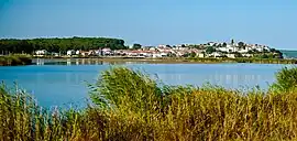
İğneada
İğneada, formerly Thynias (Greek: Θυνίας), is a town (belde) in the Demirköy District, Kırklareli Province, Turkey.[2] Its population is 2,511 (2022).[1] It lies on the Black Sea coast and is approximately 5 km (3 mi) south of the Mutludere river which forms the border with Bulgaria. The land is covered by mainly oak forests,[3] typical flora of the Yıldız (Istranca) Mountains. Forestry, fishing and tourism are the main occupations of the town population. The population in East Thrace are of different Ethnicitys, who once came from Bulgaria, Romania, Greece, Yugoslavia and Caucasus like:
- Turkish people (Türkler)
- Bosniaks (Boşnaklar)
- Albanians (Arnavutlar)
- Pomaks (Pomaklar)
- Gajal (Gacallar)
- Muhacir (Muhacirler)
- Tatars (Tatarlar)
- Hill people (Dağlılar)
- Vallahades (Patriyotlar)
- Circassians (Çerkesler)
- Romani people (Romanlar)
- Turkmens Amuca tribe (Türkmen Amucalar).[4]
İğneada | |
|---|---|
 | |
 İğneada Location in Turkey 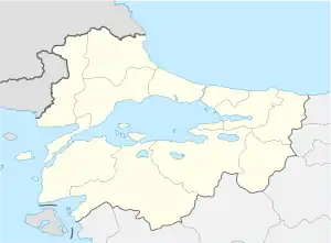 İğneada İğneada (Marmara) | |
| Coordinates: 41°52′34″N 27°59′10″E | |
| Country | Turkey |
| Province | Kırklareli |
| District | Demirköy |
| Government | |
| • Mayor | Tahir Işık (CHP) |
| Elevation | 0 m (0 ft) |
| Population (2022)[1] | 2,511 |
| Time zone | TRT (UTC+3) |
| Postal code | 39650 |
| Area code | 0288 |
| Website | www |
The İğneada Floodplain Forests National Park with its Lake Saka Nature Reserve Area is situated around the town. It harbors one of the few remaining floodplain forests in all of Europe, which is home to many different bird species.[5]
The second of Turkey's nuclear power plants is planned to be built in the area. A fourth revision environmental impact assessment was submitted and approved. There is no timeline or budget set for the project as of November 2015.[6]
References
- "Address-based population registration system (ADNKS) results dated 31 December 2022, Favorite Reports" (XLS). TÜİK. Retrieved 13 March 2023.
- Belde Belediyesi, Turkey Civil Administration Departments Inventory. Retrieved 1 March 2023.
- "İğneada: The Black Sea's best kept secret". Daily Sabah. 22 July 2016.
- https://www.atlasdergisi.com/kesfet/igneada-longozu-su-ormani.html
- https://www.trakyagezi.com/igneada/
- Nuclear Power in Turkey
External links
- İğneada municipality's official website (in Turkish)
- İğneada website (in Turkish)
| Municipalities | |
|---|---|
| Villages |
|