Independence State Airport
Independence State Airport Independence Airpark | |||||||||||
|---|---|---|---|---|---|---|---|---|---|---|---|
 | |||||||||||
| Summary | |||||||||||
| Airport type | Public | ||||||||||
| Owner | Oregon Department of Aviation | ||||||||||
| Serves | Independence, Oregon | ||||||||||
| Elevation AMSL | 180 ft / 55 m | ||||||||||
| Runways | |||||||||||
| |||||||||||
| Statistics (1999) | |||||||||||
| |||||||||||
Independence State Airport (FAA LID: 7S5) is a public-use airport located one mile (1.6 km) northwest of the central business district of Independence, a city in Polk County, Oregon, United States. It is owned by the Oregon Department of Aviation.[1]
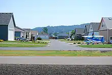
Serving as a general aviation airport, Independence also hosts a large residential airpark. This facility is Oregon's only public-use airport hosting an airpark.
Airport information and statistics
Independence State Airport covers an area of 83 acres (34 ha), which contains one runway designated 16/34 with a 2,935 x 60 ft (895 x 18 m) asphalt pavement.
For the 12-month period ending October 18, 1999, the airport had 31,658 aircraft operations, an average of 86 per day: 96% general aviation and 4% air taxi. At that time there were 142 aircraft based at this airport: 94% single-engine, 2% multi-engine and 4% ultralight.[1]
The Starduster Cafe at the airport serves breakfast and brunch.
Incidents
On September 19, 2018, a Rutan Long-EZ crashed while landing after the front landing gear collapsed, injuring the pilot.[2]
References
- FAA Airport Form 5010 for 7S5 PDF, effective 2007-12-20
- "Pilot injured after crash-landing at airport near Salem". OregonLive.com. The Associated Press. September 20, 2018. Retrieved 20 September 2018.
External links
- Independence State Airport Support Group
- Resources for this airport:
- FAA airport information for 7S5
- AirNav airport information for 7S5
- FlightAware airport information and live flight tracker
- SkyVector aeronautical chart for 7S5