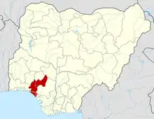
Irele
Irele is a local government area in Ondo State, Nigeria. Its headquarters are in the town of Ode-Irele. It was originally part of the old Ikale Local Government Area, which was split into Irele and Okitipupa LGAs. It has an area of 963 square kilometres (372 sq mi) and had a population of 145,166 at the 2006 census.
Irele-Ikale
Ikale Ode Irele | |
|---|---|
LGA and town | |
 Irele-Ikale Location of Ikale in Nigeria
Show map of Ikale in Nigeria Nigeria State Ondo State Great Ikale Kingdom(s) Ikalian Senatorial District South Ondo Federal Constituency Okitipupa/Irele Federal Constituency Settled 1502 kingdom Ikoya-Ikale | |
| Coordinates: 6°29′0″N 4°52′0″E | |
| Country | |
| State | Ondo State |
| Time zone | UTC+1 (WAT) |
Economy
Irele Local Government Area's economy heavily depends on farming, and the region produces a variety of crops, including pepper and yam. Because the Local Government Area is home to several markets where a range of goods are bought and sold, trade is also thriving there. Irele Local Government Area's other significant economic pursuits are hunting and blacksmithing.[1]
Geography
Irele Local Government Area has an average yearly temperature of 28 degrees Celsius and a total area of 963 square kilometres. Within the Local Government Area, the average humidity is 66%, and the total annual precipitation is predicted to be approximately 1,560 mm.[2]
Rulers of Ikale Kingdom
- Abodi of Ikale land Paramount Rulers of Ikale land
- Olofun Of Irele
- Odogbo Of Omi
- Larogbo Of Akotogbo
- Ababa Of Ajagba
- Laragunshin Of Iyansan
- Lighogho Of Iju-osun
Ikale
Ukalẹ
Total population > 750,000 (2016)
Regions with significant population
Ondo State - 700,000
Okitipupa Local Government: 316,10
Irele Local Government: 194,600
Odigbo Local Government: 269,880
Ogun Waterside Local government
Religion Christianity Yoruba religion The postal code of the area is 352.[3]
Notes and references
- "Irele Local Government Area". www.manpower.com.ng. Retrieved 26 October 2023.
- "Irele Local Government Area". www.manpower.com.ng. Retrieved 26 October 2023.
- "Post Offices- with map of LGA". NIPOST. Archived from the original on 7 October 2009. Retrieved 20 October 2009.
