Iyo Province
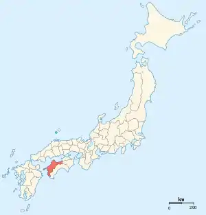
Iyo Province (伊予国, Iyo-no kuni) was a province of Japan in the area of northwestern Shikoku.[1] Iyo bordered on Sanuki Province to the northeast, Awa to the east, and Tosa to the south. Its abbreviated form name was Yoshū (予州). In terms of the Gokishichidō system, Iyo was one of the provinces of the Nankaidō circuit. Under the Engishiki classification system, Iyo was ranked as one of the "upper countries" (上国) in terms of importance, and one of the "far countries" (遠国) in terms of distance from the capital. The provincial capital was located in what is now the city of Imabari, but its exact location is still unknown. The ichinomiya of the province is the Ōyamazumi Shrine located on the island of Ōmishima in what is now part of Imabari.[2] The people spoke Iyo dialect.

History
Iyo Province was formed by the Ritsuryo reforms by combining the territories of the Iyo-no-kuni no miyatsuko (伊余国造),who ruled a territory centered on what is now the city of Iyo and town of Masaki with Kumi Province, Kazehaya Province, Touma Province, and Koichi Province each ruled by its own kuni no miyatsuko. The Geiyo Islands in the Seto Inland Sea were considered part of Aki Province into the Edo Period. During the Heian period, the coastal areas of the province were part of the stronghold of Fujiwara no Sumitomo, who led a rebellion against Imperial authority. During the Muromachi period, a branch of the Saionji family was appointed as shugo by the Ashikaga shogunate, but was constantly being invaded his more powerful and aggressive neighbors. The Saionji survived by the fluid loyalties and fierce resistance, but were eventually overcome by Chōsokabe Motochika, who was in turn overthrown by the forces of Toyotomi Hideyoshi. [3] Under the Tokugawa shogunate, the province was divided into several feudal domains.
| Name | Clan | Type | kokudaka |
|---|---|---|---|
| Hisamatsu-Matsudaira clan | Shinpan | 150,000 koku | |
| Date clan | Tozama | 100,000 koku | |
| Date clan | Tozama | 30,000 koku | |
| Katō clan | Tozama | 66,000 koku | |
| Katō clan | Tozama | 10,000 koku | |
| Hisamatsu-Matsudaira clan | Fudai | 35,000 koku | |
| Matsudaira clan | Shinpan | 30,000 koku | |
| Hitotsuyanagi clan | Tozama | 10,000 koku | |
Per the early Meiji period Kyudaka kyuryo Torishirabe-chō (旧高旧領取調帳), an official government assessment of the nation’s resources, the province had 964 villages with a total kokudaka of 434,408 koku. Iyo Province consisted of the following districts:
| District | kokudaka | villages | status | Currently |
|---|---|---|---|---|
| Uma (宇摩郡) | 22,364 koku | 56 villages | Tenryō (18); Imabari (18), Saijō (11), Tenryō/Saijō (4), Tenryō/Imabari (1) | Dissolved, now Saijō, Shikoku-chūō |
| Nii (新居郡) | 36,694 koku | 53 villages | Tenryō (6); Komatsu (4), Saijō (43), | Dissolved; now Saijō, Niihama |
| Shūfu (周敷郡) | 23,142 koku | 38 villages | Iyo-Matsuyama (25), Komatsu (9), Saijō (2), Matsuyama/Komatsu (1), Komatsu/Saijō (1) | Dissolved; now Saijō, Tōon |
| Kuwamura (桑村郡) | 14,650 koku | 29 villages | Tenryō (4); Iyo-Matsuyama (23); Tenryō/Matsuyama (1) | Dissolved; now Saijō |
| Ochi (越智郡) | 46,790 koku | 106 villages | Tenryō (8); Imabari (83); Iyo-Matsuyama (17) | merged into Ōchi District on April 18, 1896, now Imabari, Kamijima |
| Noma (野間郡) | 16,587 koku | 29 villages | Iyo-Matsuyama (29) | merged into Ōchi District on April 18, 1896; now Imabari |
| Kazahaya (風早郡) | 18,351 koku | 84 villages | Tenryō (2); Iyo-Matsuyama (78); Ozu (4); Matsuyama/Ozu (1) | Dissolved, now Matsuyama |
| Wake (和気郡) | 16,345 koku | 25 villages | Iyo-Matsuyama (25) | Dissolved, now Matsuyama |
| Onsen (温泉郡) | 22,824 koku | 36 villages | Iyo-Matsuyama (36) | Dissolved, now Matsuyama, Toon |
| Kume (久米郡) | 17,554 koku | 32 villages | Iyo-Matsuyama (32) | Dissolved, now Matsuyama, Toon |
| Ukena (浮穴郡) | 38,834 koku | 102 villages | Iyo-Matsuyama (48); Ozu (46), Niiya (7); Matsuyama/Ozu (1); Ozu/Niiya (1) | Ozu, Seiyo, Uchiko, Iyo, Matsuyama, Toon, Tobe |
| Iyo (伊予郡) | 27,949 koku | 41 villages | Iyo-Matsuyama (22); Ozu (18), Niiya (2); Matsuyama/Ozu (1); Ozu/Niiya (1) | Masaki, Tobe, Iyo |
| Kita (喜多郡) | 33,491 koku | 83 villages | Ozu (82), Niiya (4); | Ozu, Iyo, Seiyo, Naishi |
| Uwa (宇和郡) | 98,828 koku | 250 villages | Uwajima (140), Iyo-Yoshida (72); | Uwajima, Seiyo, Ozu, Naishi |
Following the abolition of the han system in 1871, Iyo Province became Ehime Prefecture.
Gallery
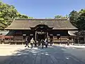 Ōyamazumi Jinja, the ichinomiya of the province
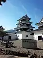 Ōzu Castle
 Matsuyama Castle, circa 1900-1902
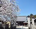 Iyo Kokubun-ji
Notes
- Nussbaum, Louis-Frédéric. (2005). "Tosa" in Japan Encyclopedia, p. 988, p. 988, at Google Books.
- "Nationwide List of Ichinomiya", p. 3.; retrieved 2011-08-09
- Nakayama, Yoshiaki (2015). 江戸三百藩大全 全藩藩主変遷表付. Kosaido Publishing. ISBN 978-4331802946.(in Japanese)
References
- Nussbaum, Louis-Frédéric and Käthe Roth. (2005). Japan encyclopedia. Cambridge: Harvard University Press. ISBN 978-0-674-01753-5; OCLC 58053128