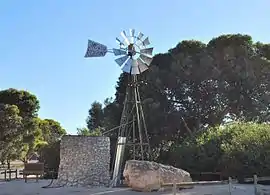
James Well, South Australia
James Well is a locality in the Australian state of South Australia located on the east coast of Yorke Peninsula immediately adjoining Gulf St Vincent about 84 kilometres (52 miles) north-west of the state capital of Adelaide and about 5 kilometres (3.1 miles) of the centre of Ardrossan.[3][2][8]
| James Well South Australia | |||||||||||||||
|---|---|---|---|---|---|---|---|---|---|---|---|---|---|---|---|
 Windmill at James Well | |||||||||||||||
 James Well | |||||||||||||||
| Coordinates | 34.480650°S 137.897480°E | ||||||||||||||
| Population | 63 (SAL 2021)[1] | ||||||||||||||
| Established | 1999[2] | ||||||||||||||
| Postcode(s) | 5571[3] | ||||||||||||||
| Time zone | ACST (UTC+9:30) | ||||||||||||||
| • Summer (DST) | ACST (UTC+10:30) | ||||||||||||||
| Location | |||||||||||||||
| LGA(s) | Yorke Peninsula Council[2] | ||||||||||||||
| Region | Yorke and Mid North[4] | ||||||||||||||
| County | Fergusson[2] | ||||||||||||||
| State electorate(s) | Narungga[5] | ||||||||||||||
| Federal division(s) | Grey[6] | ||||||||||||||
| |||||||||||||||
| |||||||||||||||
| Footnotes | Distances[3] Coordinates[2] Climate[7] Adjoining localities[2] | ||||||||||||||
Its boundaries were created in May 1999 in respect to an existing “shack site.” It was given the “long established name” which was altered from “James Wells” to “James Well.”[2][9][10] In May 2014, the locality were expanded to include land adjoining its western boundary in Sandilands.[11][12]
The locality is bounded in the main by James Well Road to the north, by the Yorke Highway to the west, by Rogue Point Road to the south and by Gulf St Vincent to the east.[8]
As of 2014, the land use within the locality is divided into the following four zones that are parallel to the coastline - a strip of land zoned as “coastal open space” which is reserved both for community use and as a buffer against sea level rise, a strip of land zoned as “settlement” which consists of an area of low density residential and associated buildings, a strip of land zoned as “deferred urban” which is agricultural land reserved for future expansion of the locality’s urban area and a strip of land at the locality’s western boundary which is zoned for “primary production.”[8]
James Well is located within the federal division of Grey, the state electoral district of Narungga and the local government area of the Yorke Peninsula Council.[2][5][6]
References
- Australian Bureau of Statistics (28 June 2022). "James Well (Suburb and Locality)". Australian Census 2021 QuickStats. Retrieved 28 June 2022.
- "Search result for "James Well (Locality Bounded)" (Record no SA0032630) with the following layers being selected - "Suburbs and Localities", "Counties", "Place names (gazetteer)" and "Road labels"". Department of Planning, Transport and Infrastructure. Archived from the original on 12 October 2016. Retrieved 25 February 2016.
- "James Well, South Australia (Postcode)". postcodes-australia.com. Retrieved 25 February 2016.
- "Yorke and Mid North SA Government region" (PDF). The Government of South Australia. Retrieved 17 April 2017.
- Narungga (Map). Electoral District Boundaries Commission. 2016. Retrieved 1 March 2018.
- "Federal electoral division of Grey". Australian Electoral Commission. Retrieved 18 August 2018.
- "Monthly climate statistics: Summary statistics PRICE". Commonwealth of Australia , Bureau of Meteorology. Retrieved 25 February 2016.
- "Development Plan - Yorke Peninsula Council" (PDF). Department of Planning, Transport and Infrastructure. pp. 120, 133, 327–329 & 447–449. Archived from the original (PDF) on 4 June 2015. Retrieved 25 February 2016.
- Kentish, P. M. (27 May 1999), "GEOGRAPHICAL NAMES ACT 1991, Notice to Assign Boundaries and Names to Places" (PDF), The South Australian Government Gazette (69): 2696, retrieved 5 December 2015
- "Search result for "James Wells (Locality Unbounded)" (Record no SA0056823)". Department of Planning, Transport and Infrastructure. Archived from the original on 12 October 2016. Retrieved 25 February 2016.
- James Well / Sandilands minor administrative suburb rb boundary alteration proposal (sic) (PDF), 2 May 2014, retrieved 26 February 2016
- Burdett, Michael (2 May 2014), GEOGRAPHICAL NAMES ACT 1991, Notice to Alter Boundaries of Places (PDF), retrieved 26 February 2016