Jarjangi
Jarjangi[2] is a Panchayath village in Kotabommali mandal (formerly Narasannapeta taluk),[3] Srikakulam district, in the Indian state of Andhra Pradesh. The Postal Index Code of this village is 532195.[4]
Jarjangi | |
|---|---|
.svg.png.webp) Jarjangi Location in Andhra Pradesh, India  Jarjangi Jarjangi (India) | |
| Coordinates: 18.5013956°N 84.1317126°E | |
| Country | |
| State | Andhra Pradesh |
| District | Srikakulam |
| Government | |
| • Type | Gram Panchayat |
| Languages | |
| • Official | Telugu |
| Time zone | UTC+5:30 (IST) |
| PIN | 532195 |
| Vehicle Registration | AP30 (Former) AP39 (from 30 January 2019)[1] |
| Lok Sabha constituency | Srikakulam |
| Vidhan Sabha constituency | Tekkali |
Jarjangi village is located on National Highway 16 (India) and Andhrapradesh SH 106.[5]
.jpg.webp)
Geography
Jarjangi is located at 18.5013956°N 84.1317126°E longitude and latitudes. This village is 28 metres above sea level.[6] Jarjangi village is nearer to Bay of Bengal . Summer season , Rainy season , winter season are the three main seasons occur in this village.
Demography
The local language is Telugu. Jarjangi village's total population is 1051 and the number of houses is 279. The female population is 52.4%. The village literacy rate is 62.2% and the female literacy rate is 26.0%. The total male population is 500; the total female population is 551.[7]
Transportation
.jpg.webp)
Jarjangi is well connected by APSRTC buses, autos and taxis.[8] APSRTC runs bus services through this village to Palasa, Tekkali, Kotabommali, Narasannapeta, and Srikakulam.
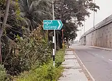
Jarjangi Junction is located on National Highway 16 and State Highway 106.
Jarjangi Junction is a main junction for changing towards Srimukhalingam, Challavanipeta, Jalumuru, Saravakota, Pathapatnam, Parlakimaidi, Narasannapeta, Srikakulam, Kotabommali, Tekkali, Palasa, Palakonda, Komanapalli, Sarubujjili , Hiramandalam, and Gotta village.
The nearest railway stations are Kotabommali railway station (KBM), Harishchandrapuram railway station (HCM), Tilaru railway station (TIU), Palasa railway station (PSA), Srikakulam Road railway station (CHE), Naupada railway station (NWP) and Tekkali Railway station (TEK).[9]
References
- "New 'AP 39' code to register vehicles in Andhra Pradesh launched". The New Indian Express. Vijayawada. 31 January 2019. Archived from the original on 28 July 2019. Retrieved 9 June 2019.
- "Jarjangi, Kotabommili Village information | Soki.In". soki.in. Retrieved 22 February 2022.
- Census 1961 - Andhra Pradesh District Census Handbook: Srikakulam District, pp. 43, 215, 431
- "JARJANGI PIN code in KOTABOMMALI MANDAL, SRIKAKULAM, ANDHRA-PRADESH. Postal Pincode in JARJANGI". www.postalpincodefor.com. Retrieved 13 December 2021.
- "Jarjangi Pindruvada Rd - Google Search". www.google.com. Retrieved 13 December 2021.
- "Weather forecast in Jarjangi". World-Weather.info. Retrieved 23 February 2022.
- "Jarjangi Population (2020/2021), Village in Kotabommili Mandal". www.indiagrowing.com. Retrieved 13 December 2021.
- "Jarjangi Bus Stop in the city Jarjangi".
- "Nearest Railway Stations to Jarjangi Jarjangi Andhra Pradesh Srikakulam - Search Nearest Railway Stations of Any Place". trainspy.com. Retrieved 23 February 2022.