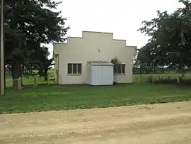
Joanna, South Australia
Joanna is a locality in the Australian state of South Australia located in the state's south-east within the state’s Limestone Coast region about 325 kilometres (202 miles) south east of the state capital of Adelaide, about 19.5 kilometres (12.1 miles) south-east of the municipal seat of Naracoorte.[1][4]
| Joanna South Australia | |||||||||||||||
|---|---|---|---|---|---|---|---|---|---|---|---|---|---|---|---|
 Hall at Joanna, July 2016 | |||||||||||||||
 Joanna | |||||||||||||||
| Coordinates | 37°7′14″S 140°51′59″E[1] | ||||||||||||||
| Population | 106 (2021 census)[2] | ||||||||||||||
| Established | 12 April 2001[3] | ||||||||||||||
| Postcode(s) | 5271[1] | ||||||||||||||
| Time zone | ACST (UTC+9:30) | ||||||||||||||
| • Summer (DST) | ACST (UTC+10:30) | ||||||||||||||
| LGA(s) | Naracoorte Lucindale Council[1] | ||||||||||||||
| Region | Limestone Coast[4] | ||||||||||||||
| County | Robe[1] | ||||||||||||||
| State electorate(s) | MacKillop[5] | ||||||||||||||
| Federal division(s) | Barker[6] | ||||||||||||||
| |||||||||||||||
| |||||||||||||||
| Footnotes | Coordinates[1] Locations[1] Climatic data[7] Adjoining localities[1][8] | ||||||||||||||
Joanna started as a private subdivision. Boundaries were created in April 2001 for the “long established name” which is derived from the cadastral unit of the Hundred of Joanna which was named in 1862 after the daughter of Dominick Daly, the then Governor of South Australia.[1][9][10]
The majority land use within the locality is primary production. The locality includes land proclaimed for conservation purposes as the Naracoorte Caves National Park.[1][11]
The full extent of the national park was listed on 17 May 2017 as a state heritage place on the South Australian Heritage Register with the name of the Naracoorte Caves Complex.[12]
Joanna shares a single CFS brigade with the neighbouring locality of Wrattonbully.
Joanna is located within the federal Division of Barker, the state electoral district of MacKillop, and the local government area of the Naracoorte Lucindale Council.[1][5][6]
Demographics
As of the 2021 Australian census, 106 people resided in Joanna,[2] up from 94 in the 2016 census.[13] The median age of persons in Joanna was 50 years. There were fewer males than females, with 45.9% of the population male and 54.1% female. The average household size was 2.4 people per household.[2]
References
- Notes
- Citations
- "Search result for "Joanna (Locality Bounded)" (Record no SA0032924) with the following layers selected - "Suburbs and Localities", "Place names (gazetteer)", "Road Labels" and "Development Plan Layers"". Property Location Browser. Government of South Australia. Archived from the original on 12 October 2016. Retrieved 1 March 2017.
- Australian Bureau of Statistics (28 June 2022). "Joanna (State Suburb)". 2021 Census QuickStats. Retrieved 7 May 2023.
- "GEOGRAPHICAL NAMES ACT 1991 Notice to Assign a Boundary to a Place (to areas within the Naracoorte Lucindale Council)" (PDF). South Australian Government Gazette. South Australian government. 12 April 2001. p. 1587. Retrieved 24 February 2018.
- "Limestone Coast SA Government region" (PDF). The Government of South Australia. Retrieved 10 October 2014.
- "District of MacKillop Background Profile". Electoral Commission SA. Retrieved 12 April 2016.
- "Federal electoral division of Barker" (PDF). Australian Electoral Commission. Retrieved 28 March 2016.
- "Monthly climate statistics: Summary statistics Struan (nearest weather station)". Commonwealth of Australia , Bureau of Meteorology. Retrieved 1 March 2017.
- "Search result for " Langkoop (Locality Bounded)" (Vicmap ID 101796)". Vicnames - The Register of Geographic Names. Government of Victoria. Retrieved 1 March 2017.
- "Place Names of South Australia - B". The Manning Index of South Australian History. State Library of South Australia. Retrieved 11 May 2017.
- "Search result for "Joanna (Hundred)" (Record no SA0032930) with the following layers selected - "Suburbs and Localities", "Place names (gazetteer)", "Road Labels" and "Hundreds"". Property Location Browser. Government of South Australia. Archived from the original on 12 October 2016. Retrieved 1 March 2017.
- "Development Plan, Naracoorte Lucindale Council, Consolidated – 29 November 2012" (PDF). Government of South Australia. pp. 130–131, 166, 179 and 181. Retrieved 25 February 2017.
- "Naracoorte Caves Complex (designated place of geological, palaeontological and speleological significance)". Heritage Places Database. South Australian Government. 17 May 2017. Retrieved 26 February 2018.
- Australian Bureau of Statistics (27 June 2017). "Joanna (State Suburb)". 2016 Census QuickStats. Retrieved 6 May 2017.