Juniper Canyon, Oregon
Juniper Canyon is a census-designated place (CDP) in Crook County, Oregon, United States. It was first listed as a CDP prior to the 2020 census.[3]
Juniper Canyon, Oregon | |
|---|---|
 Juniper Canyon  Juniper Canyon | |
| Coordinates: 44°11′38″N 120°45′34″W | |
| Country | United States |
| State | Oregon |
| County | Crook |
| Area | |
| • Total | 96.33 sq mi (249.49 km2) |
| • Land | 94.11 sq mi (243.74 km2) |
| • Water | 2.22 sq mi (5.75 km2) |
| Elevation | 3,840 ft (1,170 m) |
| Population | |
| • Total | 2,564 |
| • Density | 27.25/sq mi (10.52/km2) |
| Time zone | UTC-8 (Pacific (PST)) |
| • Summer (DST) | UTC-7 (PDT) |
| ZIP Code | 97754 (Prineville) |
| Area code(s) | 541/458 |
| FIPS code | 41-38075 |
| GNIS feature ID | 2805453[3] |
The CDP is an area of low-density housing in western Crook County, bordered to the northwest by the city of Prineville, the county seat. The CDP is bordered to the west by Oregon Route 27, to the north and east by Oregon Route 380, and to the south by Prineville Reservoir on the Crooked River, a northwest-flowing tributary of the Deschutes River. Juniper Canyon Road crosses the CDP from just outside Prineville in the northwest to its end at Prineville Reservoir State Park in the southeast.
The Juniper Canyon CDP fully encloses the CDP of Prineville Lake Acres.
References
- "ArcGIS REST Services Directory". United States Census Bureau. Retrieved October 12, 2022.
- "Census Population API". United States Census Bureau. Retrieved October 12, 2022.
- "Juniper Canyon Census Designated Place". Geographic Names Information System. United States Geological Survey, United States Department of the Interior.
- "Census of Population and Housing". Census.gov. Retrieved June 4, 2016.
Municipalities and communities of Crook County, Oregon, United States | ||
|---|---|---|
| City | 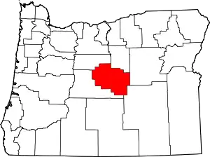 Crook County map | |
| CDPs | ||
| Other communities | ||
This article is issued from Wikipedia. The text is licensed under Creative Commons - Attribution - Sharealike. Additional terms may apply for the media files.