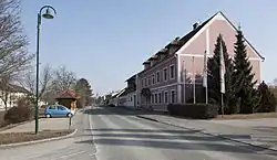
Königsdorf, Austria
Königsdorf (Hungarian: Királyfalva, Slovene: Kraljevci) is a village in the district of Jennersdorf in the Austrian state of Burgenland. In 2022 the population of the village was 768.
Königsdorf | |
|---|---|
 Municipal office | |
 Coat of arms | |
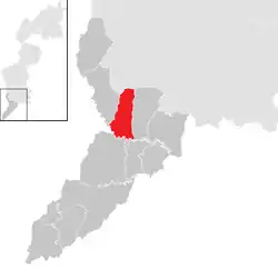
 Location within Jennersdorf district | |
 Königsdorf Location within Austria | |
| Coordinates: 47°0′N 16°10′E | |
| Country | Austria |
| State | Burgenland |
| District | Jennersdorf |
| Government | |
| • Mayor | Mario Trinkl (SPÖ) |
| Area | |
| • Total | 15.67 km2 (6.05 sq mi) |
| Elevation | 236 m (774 ft) |
| Population (2022) | |
| • Total | 768 |
| • Density | 49/km2 (130/sq mi) |
| Time zone | UTC+1 (CET) |
| • Summer (DST) | UTC+2 (CEST) |
| Postal code | 7563 |
| Website | https://www.koenigsdorf.at/ |
Geography
Königsdorf is located at an altitude of 239m, and is in the valley of the river Lafnitz. The village is 10km to the south-east of Fürstenfeld. Neighbouring settlements include Kukmirn to the north, Eltendorf and Weichselbaum to the east, Jennersdorf to the south and Bad Loipersdorf and Rudersdorf to the west.
Population
| Year | Pop. | ±% |
|---|---|---|
| 1869 | 1,373 | — |
| 1880 | 1,374 | +0.1% |
| 1890 | 1,373 | −0.1% |
| 1900 | 1,226 | −10.7% |
| 1910 | 1,183 | −3.5% |
| 1923 | 1,093 | −7.6% |
| 1934 | 1,100 | +0.6% |
| 1939 | 1,081 | −1.7% |
| 1951 | 882 | −18.4% |
| 1961 | 850 | −3.6% |
| 1971 | 805 | −5.3% |
| 1981 | 895 | +11.2% |
| 1991 | 781 | −12.7% |
| 2001 | 757 | −3.1% |
| 2011 | 711 | −6.1% |
References
- "Dauersiedlungsraum der Gemeinden Politischen Bezirke und Bundesländer - Gebietsstand 1.1.2018". Statistics Austria. Retrieved 10 March 2019.
This article is issued from Wikipedia. The text is licensed under Creative Commons - Attribution - Sharealike. Additional terms may apply for the media files.