Kashan
Kashan (Persian: کاشان, romanized: Kâšân [kɒːˈʃɒːn] ⓘ); Qashan; Cassan;[3] also romanized as Kāshān)[4] is a city in the Central District of Kashan County, in the northern part of Isfahan province, Iran, and serves as both capital of the county and of the district.
Kashan
کاشان | |
|---|---|
City | |
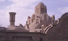  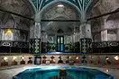   Clockwise from the top: Borujerdi House, Sultan Amir Ahmad Bathhouse, Tabatabai House, Agha Bozorg Mosque, Fin Garden. | |
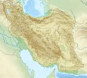 Kashan Location in Iran | |
| Coordinates: 33°58′57″N 51°25′57″E[1] | |
| Country | Iran |
| Province | Isfahan |
| County | Kashan |
| District | Central |
| Government | |
| • Mayor | Kioumars Mohammadpour |
| Population (2016)[2] | |
| • Urban | 304,487 |
| • Metro | 432,557 |
| Time zone | UTC+3:30 (IRST) |
| Website | www |
At the 2006 National Census, its population was 248,789 in 67,464 households.[5] The following census in 2011 counted 275,325 people in 80,015 households.[6] The latest census in 2016 showed a population of 304,487 people in 91,935 households.[2]
Some etymologists argue that the city name comes from the Kasian, the original inhabitants of the city, whose remains are found at Tapeh Sialk dating back 9,000 years; later this was changed to "Kashian", hence the town name. Between the 12th and the 14th centuries Kashan was an important centre for the production of high quality pottery and tiles. In modern Persian, the word for a tile (kashi) comes from the name of the town.
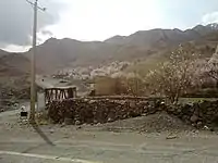
Kashan is divided into two parts, mountainous and desert. In the west side, Kashan is cited in the neighbourhood of two of highest peaks of Karkas chain, Mount Gargash to the southwest of Kashan (the home of Iran national observatory, the largest astronomical telescope of Iran) and Mount Ardehaal in the west of Kashan, also known as "Damavand of Kashan" and the highest peak of Ardehaal mountains (end part of Karkas chain in central Iran).
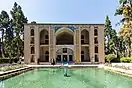
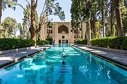
On August 9, 2007, Iran placed the Historical Axis of Fin, Sialk, Kashan on its Tentative List for possible future nomination as a UNESCO World Heritage Site. The exact definition of what locations within Kashan proper might be nominated was not made clear. In 2012 Iran successfully nominated the Fin Garden separately for inscription by UNESCO as a part of its Persian Gardens World Heritage Site. Despite this the "Historical-Cultural Axis of Fin, Sialk, Kashan" remains in full on Iran's Tentative List.
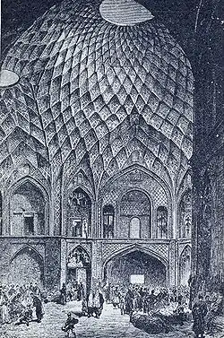
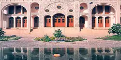
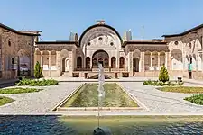
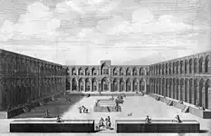
The Boroujerdiha house is one of the famous historical places from the Qajar period. This house is well known with unique architecture, which has a specific beauty. The house has two internal and external patios. Other parts consist of kitchen, porch, aisle, the summer and winter courtyards are very beautiful.
History
Earliest evidence of human presence around Kashan date back to Paleolithic period that have been found at Niasar, Kaftar Khoun and Sefid-Ab. Middle Paleolithic stone tools were discovered at travertine spring of Niasar and the travertine of Kaftar Khoun.[7] Upper Paleolithic groups were living around Sefid-Ab spring at SW of Kashan.[8] Archeological discoveries in the Sialk Hillocks which lie 4 km west of Kashan reveal that this region was one of the primary centers of civilization in pre-historic ages. Hence, Kashan dates back to the Elamite period of Iran. The Sialk ziggurat still stands today in the suburbs of Kashan after 7,000 years.
The artifacts uncovered at Sialk Mahan Pasha reside in the Louvre in Paris and the New York Metropolitan Museum of Art, and Iran's National Museum.
By some accounts, although not all, Kashan was the origin of the three wise men who followed the star that guided them to Bethlehem to witness the nativity of Jesus, as recounted in the Bible.[9] For example, medieval traveler Friar Odoric of Pordenone related this story in 1330 after having visited there.[10] Whatever the historical validity, the attribution of Kashan as their original home testifies to the city's prestige at the time the story was set down.
According to a legend dating from the Safavid era, Abu Lu'lu'a, the Persian skilled craftsman who was enslaved by the Islamic conquerors and who eventually assassinated the caliph Umar ibn al-Khattab in 644, fled to Kashan after the assassination.[11] The shrine that was built over his supposed tomb is one of Kashan's conspicuous landmarks (see gallery below).
Sultan Malik Shah I of the Seljuk dynasty ordered the building of a fortress in the middle of Kashan in the 11th century. The fortress walls, called Ghal'eh Jalali still stand today in central Kashan.
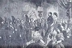
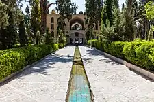
Kashan was also a leisure vacation spot for Safavid kings. Bagh-e Fin (Fin Garden), specifically, is one of the most famous gardens of Iran. This garden with its pool and orchards was designed for Shah Abbas I as a classical Persian vision of paradise. The original Safavid buildings have been substantially replaced and rebuilt by the Qajar dynasty although the layout of trees and marble basins is close to the original. The garden itself however, was first founded 7000 years ago alongside the Cheshmeh-ye-Soleiman. The garden is also notorious as the site of the murder of Mirza Taghi Khan known as Amir Kabir, chancellor of Nasser-al-Din Shah, Iran's king in 1852.
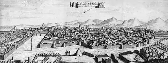
The earthquake of 1778 leveled the city of Kashan and all the edifices of Shah Abbas Safavi, leaving 8000 casualties. But the city started afresh and has today become a focal tourist attraction via the numerous large houses from the 18th and 19th centuries, illustrating the finest examples of Qajari aesthetics.
Geographical location
The city of Kashan is located in the north of Isfahan province, north of the Karkas Mountains and west of Dasht-e Kavir desert, where it is poor in terms of vegetation and where bushes and shrubs are more or less found. Dare mountain is next to Dare village and 14 kilometers southwest of Kashan with a height of 2,985 meters overlooking the city of Kashan, and Gargash peak is the highest peak of the Karkas mountain range, 33 kilometers southwest of Kashan and 12 kilometers southwest of Qamsar and 7 kilometers northeast of Kamu with a height of 3,600 meters is located near the city of Kamu and Chogan. Kashan has the least light and air pollution. For this reason, it was chosen by international experts as the most appropriate and best place to establish the National Observatory of Iran, and the home of one of the largest large telescopes in the Middle East with the latest technology. Ardahal peak is located 35 kilometers west of Kashan with a height of 3505 meters after Gargash, the highest point of Kashan heights (continuation of the central mountain range) in the vicinity of Niaser and the villages of Mazosh, Nashlej and Mashhad.[12][13]
Climate
Kashan has a hot desert climate (BWh) in Köppen climate classification and (BW) in Trewartha climate classification, with cold winters (although warmer than other Iranian cities) and hot, sometimes very hot summers. Kashan is significantly warmer than other cities in the Iranian Plateau due to its lower elevation. Its climate is somewhat similar to Qom and Yazd.
| Climate data for Kashan (1966–2010, records 1966-2020) | |||||||||||||
|---|---|---|---|---|---|---|---|---|---|---|---|---|---|
| Month | Jan | Feb | Mar | Apr | May | Jun | Jul | Aug | Sep | Oct | Nov | Dec | Year |
| Record high °C (°F) | 22.0 (71.6) |
27.0 (80.6) |
36.4 (97.5) |
37.0 (98.6) |
42.0 (107.6) |
48.0 (118.4) |
48.0 (118.4) |
47.0 (116.6) |
43.0 (109.4) |
39.0 (102.2) |
32.2 (90.0) |
24.5 (76.1) |
48.0 (118.4) |
| Average high °C (°F) | 10.0 (50.0) |
13.5 (56.3) |
19.3 (66.7) |
26.3 (79.3) |
31.9 (89.4) |
38.1 (100.6) |
40.8 (105.4) |
39.8 (103.6) |
35.2 (95.4) |
27.6 (81.7) |
18.9 (66.0) |
12.1 (53.8) |
26.1 (79.0) |
| Daily mean °C (°F) | 4.7 (40.5) |
7.6 (45.7) |
12.9 (55.2) |
19.2 (66.6) |
24.4 (75.9) |
30.1 (86.2) |
32.9 (91.2) |
31.5 (88.7) |
26.8 (80.2) |
20.1 (68.2) |
12.5 (54.5) |
6.7 (44.1) |
19.1 (66.4) |
| Average low °C (°F) | −0.6 (30.9) |
1.6 (34.9) |
6.5 (43.7) |
12.1 (53.8) |
17.0 (62.6) |
22.0 (71.6) |
24.9 (76.8) |
23.3 (73.9) |
18.4 (65.1) |
12.7 (54.9) |
6.2 (43.2) |
1.4 (34.5) |
12.1 (53.8) |
| Record low °C (°F) | −17.4 (0.7) |
−10.0 (14.0) |
−2.4 (27.7) |
0.0 (32.0) |
9.8 (49.6) |
10.6 (51.1) |
15.2 (59.4) |
12.4 (54.3) |
12.6 (54.7) |
6.0 (42.8) |
−8.6 (16.5) |
−7.0 (19.4) |
−17.4 (0.7) |
| Average precipitation mm (inches) | 25.8 (1.02) |
18.8 (0.74) |
25.4 (1.00) |
17.4 (0.69) |
13.1 (0.52) |
1.3 (0.05) |
0.5 (0.02) |
0.4 (0.02) |
0.2 (0.01) |
4.3 (0.17) |
11.7 (0.46) |
17.1 (0.67) |
136 (5.37) |
| Average snowy days | 2.7 | 1.2 | 0.5 | 0.0 | 0.0 | 0.0 | 0.0 | 0.0 | 0.0 | 0.0 | 0.1 | 1.0 | 5.5 |
| Average relative humidity (%) | 62 | 54 | 46 | 39 | 34 | 25 | 23 | 24 | 27 | 38 | 50 | 61 | 40 |
| Source: | |||||||||||||
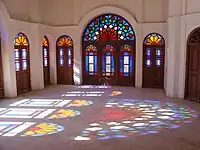
Main sights

Kashan's architectural sights include:
- 40 Dokhtaran Fortress
- Abbāsi House
- Attarha House
- Al-e Yaseen House
- Agha Bozorg Mosque
- Āmeri House
- Bazaar of Kashan
- Boroujerdi House
- Fin Garden
- Fin Bathroom
- Ghal'eh jalali
- Jalali Castle
- Jameh Mosque of Kashan
- Manouchehris House
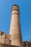
- Menar tower
- Meydan Mosque
- Shrine of Abu Lu'lu'a (shrine dedicated to the assassin of Umar, the second Islamic caliph)
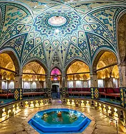
- Sultan Amir Ahmad Bathhouse
- Tabātabāei House
- Tabriziha Mosque
- Tepe Sialk
- Timcheh Amin-o-dowleh
Today
Although there are many sites in Kashan of potential interest to tourists, the city remains largely undeveloped in this sector, with fewer than a thousand foreign tourists per year. Notable towns around Kashan are Qamsar and Abyaneh, which attract tourists all year around. The nearby town of Niasar features a man-made cave and fireplace of historical interest.
Kashan is known for the manufacture of carpets, silk and other textiles. Today, Kashan houses most of Iran's mechanized carpet-weaving factories after Aran va bidgol, and has an active marble and copper mining industry. Kashan and suburbs have a population of 400,000.
Education
There are more than 10,000 students currently studying in various fields (e.g.:Applied sciences, Engineering, Art, Law, Medical sciences, Nano technology, literature, Carpet and Handicrafts, etc.) at universities of Kashan. Colleges and universities in Kashan include:
Accessibility
Kashan is connected via freeways to Isfahan and Natanz to the South, and Qom, which is an hour drive away to the north.
Kashan railway station is along the main north–south railways of Iran.
Kashan Airport reopened on 2 June 2016 after twenty years hiatus with an ATA Airlines flight from Mashhad International Airport. The airport aims to launch flights to Kish Island and Qehshm Island in Iran and Najaf in Iraq.
Notable people
.jpg.webp)
- David Alliance, Baron Alliance
- Ghyath ad-Din Jamshid Kashani
- Kamal-ol-Molk
- Amir Ghafour
- Ehsan Hajsafi
- Javad Kazemian
- Mohsen Feyz Kashani
- Sohrab Sepehri
- Ustad Ali Maryam
- Afdal al-Din Kashani
 Kashan Former Entrance
 - Reza Abbasi
- Sani ol molk
- Kalim Kashani
- Muhtasham Kashani
- Ghotb Ravandi
- Saeed Hajjarian
- Mohammad Motamedi
- Mulla Muhammad Mahdi Naraqi
- Molla Fathollah Kashani
- Sani ol molk
Molok zarabi Parivash zangane
Twin towns – sister cities
 Neishabour, Iran
Gallery
.jpg.webp)
 Interior of Tabatabaeis House
 Chardin Caravanseray
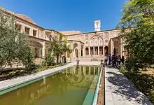
 Soleimaniye spring
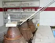 A manufactory of rose water in Kashan
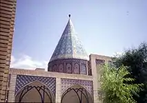 Shrine of Abu Lu'lu'a, not far from Fin Garden
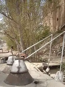
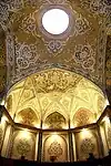 interior of Soltan Amir Ahmad Bathhouse
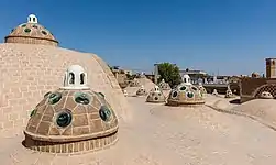
 Darre Pariyan (Angels Valley)
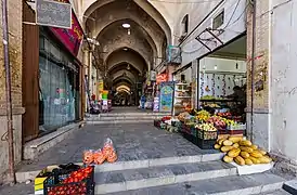
 Friday Mosque of Kashan
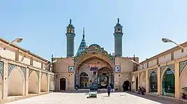 Sultan Amir Ahmad Mosque
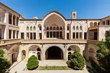 Abbasi House
See also
References
- OpenStreetMap contributors (16 June 2023). "Kashan, Kashan County" (Map). OpenStreetMap. Retrieved 16 June 2023.
- "Census of the Islamic Republic of Iran, 1395 (2016)". AMAR (in Persian). The Statistical Center of Iran. p. 10. Archived from the original (Excel) on 19 October 2020. Retrieved 19 December 2022.
- Henry Yule, Cathay and the Way Thither, Volume II, edited by Henri Cordier for the Hakluyt Society, 1913, p. 106, FN 4.
- Kashan can be found at GEOnet Names Server, at this link, by opening the Advanced Search box, entering "-3069961" in the "Unique Feature Id" form, and clicking on "Search Database".
- "Census of the Islamic Republic of Iran, 1385 (2006)". AMAR (in Persian). The Statistical Center of Iran. p. 10. Archived from the original (Excel) on 20 September 2011. Retrieved 25 September 2022.
- "Census of the Islamic Republic of Iran, 1390 (2011)" (Excel). Iran Data Portal (in Persian). The Statistical Center of Iran. p. 10. Retrieved 19 December 2022.
- Biglari, F. (2004) The Preliminary Survey of Paleolithic Sites in the Kashan region., In S.M. Shahmirzadi (ed.), The Silversmiths of Sialk (Sialk Reconsideration Project), Report No. 2: 151-168. Archaeological Research Center. Iranian Cultural Heritage Organization,Tehran. (In Persian)
- Shidrang, S 2009 A Typo-technological Study of an Upper Paleolithic Collection from Sefid-Ab, Central Iran, In: M. Otte, F. Biglari, and J. Jaubert (eds), Iran Palaeolithic. pp. 47–56, Proceedings of the XV World Congress UISPP, Lisbonne, Vol. 28, BAR International Series 1968
- Elgood, Cyril. A Medical History of Persia and the Eastern Caliphate: From the Earliest Times Until the Year A.D. 1932. Cambridge Library Collection - History of Medicine. Cambridge University Press, 2010. ISBN 1108015883 p. 34
- Henry Yule, Cathay and the Way Thither, Volume II, edited by Henri Cordier for the Hakluyt Society, 1913, p. 106.
- Johnson, Rosemary Stanfield (1994). "Sunni Survival in Safavid Iran: Anti‐Sunni Activities During the Reign of Tahmasp I". Iranian Studies. 27 (1–4): 123–133. doi:10.1080/00210869408701823. JSTOR 4310889. p. 127, note 23. On Abu Lu'lu'a, see Pellat, Charles (2011). "Abū Loʾloʾa". In Yarshater, Ehsan (ed.). Encyclopaedia Iranica.
- "Kashan". www.visitiran.ir. Retrieved 17 March 2023.
- Foundation, Encyclopaedia Iranica. "Welcome to Encyclopaedia Iranica". iranicaonline.org. Retrieved 17 March 2023.
External links
- Kashan Municipality
- Ghaffari Clan of Kashan
- University of Kashan
- Kashan University of medical sciences
- Islamic Azad university of Kashan
- Kashan Culture Foundation
- Art from Kashan at the Metropolitan Museum of Art

| Capital | |||||||||||||||||||||||||||||||||||||||||||
|---|---|---|---|---|---|---|---|---|---|---|---|---|---|---|---|---|---|---|---|---|---|---|---|---|---|---|---|---|---|---|---|---|---|---|---|---|---|---|---|---|---|---|---|
| Districts |
| ||||||||||||||||||||||||||||||||||||||||||
| Periods |
|  | ||||
|---|---|---|---|---|---|---|
| Types | ||||||
| Elements | ||||||
| Traditional cities | ||||||
| Theory and analysis | ||||||
| Lists |
| |||||