Kahutara, New Zealand
Kahutara is a rural locality and a statistical area in the South Wairarapa District and Wellington Region of New Zealand's North Island. The locality is east of Lake Wairarapa and west of Martinborough. The statistical area covers the area around Lake Wairarapa and extends southwest to Ocean Beach on Palliser Bay.
Kahutara | |
|---|---|
Locality | |
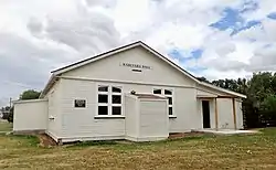
 Kahutara Hall | |
| Coordinates: 41.228°S 175.344°E | |
| Region | Wellington Region |
| Territorial authority | South Wairarapa District |
| Ward | Martinborough Ward |
| Community | Martinborough Community |
| Electorates | |
| Government | |
| • Territorial Authority | South Wairarapa District Council |
| • Regional council | Greater Wellington Regional Council |
| • Mayor of South Wairarapa | Martin Connelly |
| • Wairarapa MP | Mike Butterick |
| • Ikaroa-Rāwhiti MP | Cushla Tangaere-Manuel |
| Area | |
| • Total | 158.45 km2 (61.18 sq mi) |
| Population (2018 Census)[2] | |
| • Total | 480 |
| • Density | 3.0/km2 (7.8/sq mi) |
Demographics
Kahutara is in three SA1 statistical areas which cover 158.45 km2 (61.18 sq mi).[1] The SA1 areas are part of the larger Kahutara statistical area.
| Year | Pop. | ±% p.a. |
|---|---|---|
| 2006 | 450 | — |
| 2013 | 471 | +0.65% |
| 2018 | 480 | +0.38% |
| Source: [2] | ||
The locality had a population of 480 at the 2018 New Zealand census, an increase of 9 people (1.9%) since the 2013 census, and an increase of 30 people (6.7%) since the 2006 census. There were 180 households, comprising 270 males and 213 females, giving a sex ratio of 1.27 males per female, with 111 people (23.1%) aged under 15 years, 102 (21.2%) aged 15 to 29, 222 (46.2%) aged 30 to 64, and 42 (8.8%) aged 65 or older.
Ethnicities were 91.2% European/Pākehā, 12.5% Māori, 1.9% Pasifika, 3.1% Asian, and 2.5% other ethnicities. People may identify with more than one ethnicity.
Although some people chose not to answer the census's question about religious affiliation, 63.8% had no religion, 27.5% were Christian and 1.2% had other religions.
Of those at least 15 years old, 60 (16.3%) people had a bachelor's or higher degree, and 60 (16.3%) people had no formal qualifications. 66 people (17.9%) earned over $70,000 compared to 17.2% nationally. The employment status of those at least 15 was that 219 (59.3%) people were employed full-time, 60 (16.3%) were part-time, and 6 (1.6%) were unemployed.[2]
Kahutara statistical area
Kahutara statistical area covers 457.40 km2 (176.60 sq mi)[1] and had an estimated population of 1,150 as of June 2023,[3] with a population density of 3 people per km2.
| Year | Pop. | ±% p.a. |
|---|---|---|
| 2006 | 933 | — |
| 2013 | 975 | +0.63% |
| 2018 | 1,035 | +1.20% |
| Source: [4] | ||
The statistical area had a population of 1,035 at the 2018 New Zealand census, an increase of 60 people (6.2%) since the 2013 census, and an increase of 102 people (10.9%) since the 2006 census. There were 396 households, comprising 549 males and 486 females, giving a sex ratio of 1.13 males per female. The median age was 41.1 years (compared with 37.4 years nationally), with 213 people (20.6%) aged under 15 years, 180 (17.4%) aged 15 to 29, 522 (50.4%) aged 30 to 64, and 117 (11.3%) aged 65 or older.
Ethnicities were 91.6% European/Pākehā, 11.9% Māori, 1.7% Pasifika, 2.3% Asian, and 2.9% other ethnicities. People may identify with more than one ethnicity.
The percentage of people born overseas was 15.4, compared with 27.1% nationally.
Although some people chose not to answer the census's question about religious affiliation, 61.2% had no religion, 29.9% were Christian, 0.3% had Māori religious beliefs, 0.3% were Hindu, 0.3% were Buddhist and 2.0% had other religions.
Of those at least 15 years old, 153 (18.6%) people had a bachelor's or higher degree, and 156 (19.0%) people had no formal qualifications. The median income was $41,000, compared with $31,800 nationally. 165 people (20.1%) earned over $70,000 compared to 17.2% nationally. The employment status of those at least 15 was that 477 (58.0%) people were employed full-time, 141 (17.2%) were part-time, and 18 (2.2%) were unemployed.[4]
Education

Kahutara School is a co-educational state primary school for Year 1 to 8 students,[5] with a roll of 98 as of April 2023.[6] The school was founded in 1898.[7]
References
- "ArcGIS Web Application". statsnz.maps.arcgis.com. Retrieved 9 July 2023.
- "Statistical area 1 dataset for 2018 Census". Statistics New Zealand. March 2020. 7022415, 7022434 and 7022435.
- "Population estimate tables - NZ.Stat". Statistics New Zealand. Retrieved 25 October 2023.
- "Statistical area 1 dataset for 2018 Census". Statistics New Zealand. March 2020. Kahutara (257400). 2018 Census place summary: Kahutara
- Education Counts: Kahutara School
- "New Zealand Schools Directory". New Zealand Ministry of Education. Retrieved 12 December 2022.
- "School History". Kahutara School. Retrieved 19 July 2021.