Kansas statistical areas

The U.S. State of Kansas currently has 23 statistical areas that have been delineated by the Office of Management and Budget (OMB). On March 6, 2020, the OMB delineated two combined statistical areas, six metropolitan statistical areas, and 15 micropolitan statistical areas in Kansas.[1]
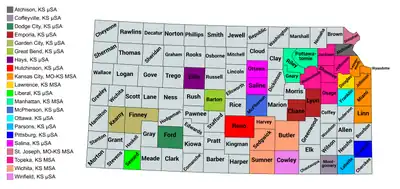
Map of the 21 core-based statistical areas in Kansas.
An enlargeable map of the 21 core-based statistical areas in Kansas.[1]

Statistical areas

The Office of Management and Budget (OMB) has designated more than 1,000 statistical areas for the United States and Puerto Rico.[2] These statistical areas are important geographic delineations of population clusters used by the OMB, the United States Census Bureau, planning organizations, and federal, state, and local government entities.

The OMB defines a core-based statistical area (commonly referred to as a CBSA) as "a statistical geographic entity consisting of the county or counties (or county-equivalents) associated with at least one core[lower-alpha 1] of at least 10,000 population, plus adjacent counties having a high degree of social and economic integration with the core as measured through commuting ties with the counties containing the core."[2] The OMB further divides core-based statistical areas into metropolitan statistical areas (MSAs) that have "a population of at least 50,000" and micropolitan statistical areas (μSAs) that have "a population of at least 10,000, but less than 50,000."[2]

The OMB defines a combined statistical area (CSA) as "a geographic entity consisting of two or more adjacent core-based statistical areas with employment interchange measures[lower-alpha 2] of at least 15%."[2] The primary statistical areas (PSAs) include all combined statistical areas and any core-based statistical area that is not a constituent of a combined statistical area.

Table

The table below describes the 23 United States statistical areas and 105 counties of the State of Kansas with the following information:[3]

  1. The combined statistical area (CSA) as designated by the OMB.[1]
  2. The CSA population according to 2019 US Census Bureau population estimates.[4]
  3. The core based statistical area (CBSA)[2] as designated by the OMB.[1]
  4. The CBSA population according to 2019 US Census Bureau population estimates [4]
  5. The county name
  6. The county population according to 2019 US Census Bureau population estimates [4]
The 23 United States statistical areas and 105 counties of the State of Kansas

Combined Statistical Area 2019 Population Core Based Statistical Area 2019 Population County 2019 Population
Kansas City-Overland Park-Kansas City, MO-KS CSA 2,501,151
1,065,004
Kansas City, MO-KS MSA 2,157,990
893,528
Jackson County, Missouri 703,011
Johnson County, Kansas 602,401
Clay County, Missouri 249,948
Wyandotte County, Kansas 165,429
Cass County, Missouri 105,780
Platte County, Missouri 104,418
Leavenworth County, Kansas 81,758
Miami County, Kansas 34,237
Lafayette County, Missouri 32,708
Ray County, Missouri 23,018
Clinton County, Missouri 20,387
Bates County, Missouri 16,172
Linn County, Kansas 9,703
Caldwell County, Missouri 9,020
St. Joseph, MO-KS MSA 125,223
7,600
Buchanan County, Missouri 87,364
Andrew County, Missouri 17,712
DeKalb County, Missouri 12,547
Doniphan County, Kansas 7,600
Lawrence, KS MSA 122,259 Douglas County, Kansas 122,259
Warrensburg, MO μSA 54,062 Johnson County, Missouri 54,062
Ottawa, KS μSA 25,544 Franklin County, Kansas 25,544
Atchison, KS μSA 16,073 Atchison County, Kansas 16,073
Wichita-Winfield, KS CSA 675,126 Wichita, KS MSA 640,218 Sedgwick County, Kansas 516,042
Butler County, Kansas 66,911
Harvey County, Kansas 34,429
Sumner County, Kansas 22,836
Winfield, KS μSA 34,908 Cowley County, Kansas 34,908
none Topeka, KS MSA 231,969 Shawnee County, Kansas 176,875
Jefferson County, Kansas 19,043
Osage County, Kansas 15,949
Jackson County, Kansas 13,171
Wabaunsee County, Kansas 6,931
Manhattan, KS MSA 130,285 Riley County, Kansas 74,232
Geary County, Kansas 31,670
Pottawatomie County, Kansas 24,383
Hutchinson, KS μSA 61,998 Reno County, Kansas 61,998
Salina, KS μSA 59,928 Saline County, Kansas 54,224
Ottawa County, Kansas 5,704
Garden City, KS μSA 40,305 Finney County, Kansas 36,467
Kearny County, Kansas 3,838
Pittsburg, KS μSA 38,818 Crawford County, Kansas 38,818
Emporia, KS μSA 35,843 Lyon County, Kansas 33,195
Chase County, Kansas 2,648
Dodge City, KS μSA 33,619 Ford County, Kansas 33,619
Coffeyville, KS μSA 31,829 Montgomery County, Kansas 31,829
Hays, KS μSA 28,553 Ellis County, Kansas 28,553
McPherson, KS μSA 28,542 McPherson County, Kansas 28,542
Great Bend, KS μSA 25,779 Barton County, Kansas 25,779
Liberal, KS μSA 21,428 Seward County, Kansas 21,428
Parsons, KS μSA 19,618 Labette County, Kansas 19,618
none Cherokee County, Kansas 19,939
Dickinson County, Kansas 18,466
Neosho County, Kansas 16,007
Bourbon County, Kansas 14,534
Allen County, Kansas 12,369
Marion County, Kansas 11,884
Nemaha County, Kansas 10,231
Marshall County, Kansas 9,707
Brown County, Kansas 9,564
Rice County, Kansas 9,537
Pratt County, Kansas 9,164
Cloud County, Kansas 8,786
Wilson County, Kansas 8,525
Coffey County, Kansas 8,179
Clay County, Kansas 8,002
Anderson County, Kansas 7,858
Thomas County, Kansas 7,777
Kingman County, Kansas 7,152
Grant County, Kansas 7,150
Russell County, Kansas 6,856
Pawnee County, Kansas 6,414
Ellsworth County, Kansas 6,102
Gray County, Kansas 5,988
Greenwood County, Kansas 5,982
Mitchell County, Kansas 5,979
Sherman County, Kansas 5,917
Morris County, Kansas 5,620
Stevens County, Kansas 5,485
Harper County, Kansas 5,436
Washington County, Kansas 5,406
Norton County, Kansas 5,361
Phillips County, Kansas 5,234
Rooks County, Kansas 4,920
Scott County, Kansas 4,823
Republic County, Kansas 4,636
Barber County, Kansas 4,427
Stafford County, Kansas 4,156
Meade County, Kansas 4,033
Haskell County, Kansas 3,968
Smith County, Kansas 3,583
Osborne County, Kansas 3,421
Chautauqua County, Kansas 3,250
Woodson County, Kansas 3,138
Rush County, Kansas 3,036
Lincoln County, Kansas 2,962
Jewell County, Kansas 2,879
Decatur County, Kansas 2,827
Trego County, Kansas 2,803
Edwards County, Kansas 2,798
Logan County, Kansas 2,794
Ness County, Kansas 2,750
Cheyenne County, Kansas 2,657
Gove County, Kansas 2,636
Morton County, Kansas 2,587
Hamilton County, Kansas 2,539
Elk County, Kansas 2,530
Rawlins County, Kansas 2,530
Sheridan County, Kansas 2,521
Graham County, Kansas 2,482
Kiowa County, Kansas 2,475
Wichita County, Kansas 2,119
Stanton County, Kansas 2,006
Clark County, Kansas 1,994
Hodgeman County, Kansas 1,794
Comanche County, Kansas 1,700
Lane County, Kansas 1,535
Wallace County, Kansas 1,518
Greeley County, Kansas 1,232
State of Kansas 2,913,314

See also

Notes

  1. The OMB defines a core as "a densely settled concentration of population, comprising an Urban Area (of 10,000 or more population) delineated by the Census Bureau, around which a core-based statistical area is delineated."[2]
  2. The OMB defines the employment interchange measure as "the sum of the percentage of workers living in the smaller entity who work in the larger entity plus the percentage of employment in the smaller entity that is accounted for by workers who reside in the larger entity."[2]

References

  1. Revised Delineations of Metropolitan Statistical Areas, Micropolitan Statistical Areas, and Combined Statistical Areas, and Guidance on Uses of the Delineations of These Areas (March 6, 2020). "0MB BULLETIN NO. 20-01" (PDF). Office of Management and Budget. Retrieved December 13, 2021.{{cite web}}: CS1 maint: multiple names: authors list (link)
  2. "2020 Standards for Delineating Core Based Statistical Areas". Office of Management and Budget. July 16, 2021. Retrieved December 13, 2021.
  3. An out-of-state area and its population are displayed in green. An area that extends into more than one state is displayed in teal. A teal population number over a black population number show the total population versus the in-state population.
  4. "Annual Estimates of the Resident Population for Counties in the United States: April 1, 2010 to July 1, 2019". United States Census Bureau, Population Division. April 2020. Retrieved April 9, 2020.

38.4937°N 98.3804°W / 38.4937; -98.3804 (State of Kansas)

This article is issued from Wikipedia. The text is licensed under Creative Commons - Attribution - Sharealike. Additional terms may apply for the media files.