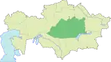
Karaganda
Karaganda or Qaraghandy (Kazakh: Қарағанды/Qarağandy, pronounced [qɑɾɑˈʁɑndə] ⓘ; Russian: Караганда, pronounced [kərəɡɐnˈda]) is the capital of Karaganda Region in the Republic of Kazakhstan. It is the fifth most populous city in Kazakhstan, behind Almaty (Alma-Ata), Astana, Shymkent and Aktobe. Population: 497,777 (2020 Estimate);[3] 459,778 (2009 Census results);[4] 436,864 (1999 Census results).[4] Karaganda is approximately 230 km (140 mi) south-east of Kazakhstan's capital Astana.
Karagandy
Қарағанды Qarağandy | |
|---|---|
City | |
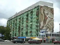
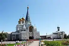
From the top, Palace of Culture at night, Karaganda Catholic Cathedral, Karaganda Orthodox Church Statue of Nurken Abdirov in Karaganda | |
 Seal | |
 Karagandy Location in Kazakhstan | |
| Coordinates: 49°48′10″N 73°06′20″E | |
| Country | Kazakhstan |
| Region | Qaraghandy Region |
| Founded | 1931 |
| Government | |
| • Akim (mayor) | Meiram Kozhukhov[1] |
| Area | |
| • Total | 497.8 km2 (192.2 sq mi) |
| Elevation | 546 m (1,791 ft) |
| Population (2020)[2] | |
| • Total | 497,777 |
| • Density | 1,000/km2 (2,600/sq mi) |
| Time zone | UTC+6 (ALMT) |
| Postal code | 100000 - 100030 |
| Area code | +7 7212 |
| Vehicle registration | M and 09 (region) |
| Climate | Dfb |
| Website | karaganda-akimat |
.jpg.webp)

In the 1940s, up to 70% of the city's inhabitants were ethnic Germans. Most of the ethnic Germans were Soviet Volga Germans who were collectively deported to Siberia and Kazakhstan on Stalin's order when Hitler invaded Soviet-annexed eastern Poland and the Soviet Union proper in 1941.Until the 1950s, many of these deportees were interned in labor camps, often simply because they were of German descent. The population of Karaganda fell by 14% from 1989 to 1999 following the dissolution of the Soviet Union; it was once Kazakhstan's second-largest city after Almaty. Over 100,000 people have since emigrated to Germany. There is also a concentration of ethnic Poles in the city.
It is Kazakhstan's most polluted city.[5]
Etymology
The name "Karaganda" is derived from "caragana" bushes (Caragana arborescens, Caragana frutex), which are abundant in the area.
History
Old Town
_%D1%81_%D0%B4%D0%B5%D0%BB%D0%B5%D0%BA%D0%B0.jpg.webp)
Modern-day Karaganda dates back to 1833, when local shepherd Appak Baizhanov allegedly found coal on the site of the city, prompting a coal mining boom.[6] By the late 19th century, the local mines had attracted workers from nearby villages, Russian merchants, and entrepreneurs from France and England.[6] After this initial boom, the mines were abandoned, but is often still labeled on city maps as the "Old Town", but almost nothing remains on that site.
Re-settlement
Coal mining in the area resumed in 1930, and temporary structures were built for miners and their families.[6] The new area for the city was to the south of the initial mines. In 1931, Karaganda was incorporated as a village, and in 1934, was declared a city.[6] Lead by planner Alexander Ivanovich Kuznetsov, masters plans for Karaganda were laid out from 1934 until 1938.[6]
During the late 1930s, the Karlag Prison was built.[6] During the Stalinist purges, peoples from many different nationalities, including Germans, Karachais, Kalmyks, Chechens, Ingush, Greeks, and Crimean Tatars were sent to Karlag.[6]
Robert F. Kennedy (later US Attorney General and US Senator), alongside US Supreme Court Justice William O. Douglas, visited "five Soviet Central Asian Republics": Turkmenistan, Uzbekistan, Tadzhikistan, Kirghizia, and Kazakhstan. While on the six week trip (e.g., Bukhara, 300 to 1 mosque after Soviet rule), his biographers reported that their delegation was not allowed to visit the city of Karaganda which was one of the sites of the most notorious labor camps within the confines of the Soviet Union. The delegation was diverted to Siberia after four denials of visas.[7]
EMP incident
Karaganda suffered the most severe electromagnetic pulse effects ever observed when its electrical power plant was set on fire by currents induced in a 1,000 km (620 mi) long shallow buried power cable by Soviet Test ‘184’ on 22 October 1962. The test was part of the Soviet Project K nuclear tests (ABM System A proof tests), and consisted of a 300-kiloton high-altitude nuclear explosion at an altitude of 290 km (180 mi) over Zhezkazgan.
Prompt gamma ray-produced EMP induced a current of 2,500 amps measured by spark gaps in a 570 km (350 mi) stretch of overhead telephone line to Zharyq, blowing all the protective fuses. The late-time MHD-EMP was of low enough frequency to enable it to penetrate 90 cm (35 in) into the ground, overloading a shallow buried lead and steel tape-protected 1,000 km (620 mi) long power cable between Aqmola (now called Astana) and Almaty. It fired circuit breakers and set the Karaganda power plant on fire.[8]
Late 20th century
Kuznetsov's master plan for the city was intended to accommodate 300,000 inhabitants, which was surpassed by the late 1960s.[6] This prompted planners to devise a new plan with the goal of accommodating 600,000 people.[6] By the 1980s, the city's population surpassed 600,000 people, creating the need for further expansion.[6] In 1983, the Karaganda Circus was constructed, which was criticized for its high cost.[6]
In the early 1990s, Karaganda was briefly considered as a candidate for the capital of the (then) newly independent Republic of Kazakhstan, but its bid was turned down in favour of Astana.
Archaeological findings
In July 2019, remains of a young couple buried face to face dated 4,000 years back were unearthed in Karaganda region in central Kazakhstan by a group of archaeologists led by Igor Kukushkin from Saryarka Archaeological Institute in Karaganda. It is assumed that the Bronze Age couple were 16 or 17 years old when they died. Kukushkin supposes that they were from a 'noble family' thanks to the buried gold and jewelry artifacts, ceramic pots, woman's two bracelets on each arm beads, remains of horses and knives found in the grave.[9][10][11]
Geography
Karaganda is located in a steppe area of the Kazakh Uplands at an elevation of 546 m (1,791 ft). To the northeast flows the Nura river and to the west the Sherubainura, its main tributary. In the southern part of the city lies the Fedorov Reservoir, built in 1941 by filling a coal mine pit with the water of river Sokyr that flows along the southern limit. The Bugyly Range (Бұғылы), reaching a height of 1,187 m (3,894 ft), rises about 60 km (37 mi) to the south of the city. The Bugyly Nature Reserve is located in the range.[12][13]
Climate
Karaganda has a humid continental climate (Köppen climate classification Dfb) with warm summers and very cold winters. Precipitation is moderately low throughout the year, although slightly heavier from May to July. Snow is frequent, though light, in winter. The lowest temperature on record is −42.9 °C (−45.2 °F), recorded in 1938, and the highest temperature is 40.2 °C (104.4 °F), recorded in 2002.[14]
| Climate data for Karaganda (1991–2020, extremes 1932–present) | |||||||||||||
|---|---|---|---|---|---|---|---|---|---|---|---|---|---|
| Month | Jan | Feb | Mar | Apr | May | Jun | Jul | Aug | Sep | Oct | Nov | Dec | Year |
| Record high °C (°F) | 6.2 (43.2) |
7.0 (44.6) |
22.3 (72.1) |
30.8 (87.4) |
35.6 (96.1) |
39.1 (102.4) |
39.6 (103.3) |
40.2 (104.4) |
37.4 (99.3) |
27.6 (81.7) |
18.4 (65.1) |
11.5 (52.7) |
40.2 (104.4) |
| Average high °C (°F) | −9.2 (15.4) |
−7.6 (18.3) |
−0.6 (30.9) |
12.9 (55.2) |
20.4 (68.7) |
25.4 (77.7) |
26.4 (79.5) |
25.5 (77.9) |
19.0 (66.2) |
10.9 (51.6) |
−0.6 (30.9) |
−7.1 (19.2) |
9.6 (49.3) |
| Daily mean °C (°F) | −13.4 (7.9) |
−12.5 (9.5) |
−5.4 (22.3) |
6.4 (43.5) |
13.5 (56.3) |
18.8 (65.8) |
20.0 (68.0) |
18.6 (65.5) |
12.1 (53.8) |
4.8 (40.6) |
−5.0 (23.0) |
−11.2 (11.8) |
3.9 (39.0) |
| Average low °C (°F) | −17.7 (0.1) |
−17.2 (1.0) |
−9.8 (14.4) |
0.8 (33.4) |
6.9 (44.4) |
12.3 (54.1) |
13.9 (57.0) |
12.1 (53.8) |
5.9 (42.6) |
−0.1 (31.8) |
−8.7 (16.3) |
−15.3 (4.5) |
−1.4 (29.5) |
| Record low °C (°F) | −41.7 (−43.1) |
−41.0 (−41.8) |
−34.7 (−30.5) |
−23.9 (−11.0) |
−9.5 (14.9) |
−2.3 (27.9) |
3.2 (37.8) |
−0.8 (30.6) |
−8.4 (16.9) |
−19.3 (−2.7) |
−38 (−36) |
−42.9 (−45.2) |
−42.9 (−45.2) |
| Average precipitation mm (inches) | 25 (1.0) |
24 (0.9) |
27 (1.1) |
30 (1.2) |
37 (1.5) |
43 (1.7) |
52 (2.0) |
29 (1.1) |
21 (0.8) |
30 (1.2) |
33 (1.3) |
31 (1.2) |
382 (15.0) |
| Average extreme snow depth cm (inches) | 21 (8.3) |
26 (10) |
17 (6.7) |
1 (0.4) |
0 (0) |
0 (0) |
0 (0) |
0 (0) |
0 (0) |
0 (0) |
4 (1.6) |
13 (5.1) |
26 (10) |
| Average rainy days | 1 | 1 | 4 | 9 | 14 | 12 | 14 | 10 | 9 | 9 | 6 | 2 | 91 |
| Average snowy days | 20 | 19 | 15 | 6 | 1 | 0 | 0 | 0 | 1 | 7 | 15 | 19 | 103 |
| Average relative humidity (%) | 79 | 78 | 78 | 61 | 54 | 50 | 55 | 52 | 53 | 66 | 77 | 78 | 65 |
| Mean monthly sunshine hours | 106 | 142 | 189 | 231 | 297 | 335 | 330 | 303 | 247 | 141 | 108 | 99 | 2,528 |
| Source 1: Pogoda.ru.net[14] | |||||||||||||
| Source 2: NOAA (sun, 1961–1990)[15] | |||||||||||||
Industry
Karaganda is an industrial city, built to exploit nearby coal mines using the slave work of prisoners of labour camps during Stalin's reign. Flora Leipman, a British citizen, spent several years unlawfully detained in a number of other nearby camps (built for prisoners of war, foreign citizens accused of espionage, and political prisoners), and described her experiences in the book "The Long Journey Home" (published 1987). The labor camp described in One Day in the Life of Ivan Denisovich where the author Aleksandr Solzhenitsyn had served some time was located near Karaganda. Commercial extraction of coal continues to be an important activity in the region even today.
Since local water resources are not sufficient for the needs of a major industrial city, the Irtysh–Karaganda Canal was constructed in the 1960s, to supply the Karaganda metropolitan area with water from the Irtysh River more than 400 km away.
Culture
Religion
The city is the seat of the Roman Catholic Diocese of Karaganda.
Theater
The Miners Palace of Culture is a major landmark in Karaganda.
Sports
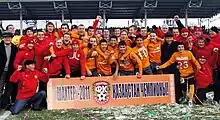
FC Shakhter Karagandy is a football club based in the city who play at Shakhtyor Stadium. They finished 7th in the Kazakhstan Premier League in 2022. They last won the competition in the 2012 season and also won the Kazakhstan Cup in 2013. One of the biggest accomplishments of the club is a victory against Celtic from Scotland in the Champions League qualifying rounds in 2013. The score was 2–0. Saryarka Karagandy is a very successful ice hockey team who are the current Kazakhstan Pro Hockey League champions and who used to play in the Russian-based Supreme Hockey League (VHL)
Monuments
On May 28, 2011, a monument to the famous catchphrase "Where-where? In Karaganda!"[16]
On May 31, 2022, on the Day of Remembrance of the Victims of Political Repressions in the Karaganda Ethnopark, a new monument to the victims of the Holodomor was opened.[17] The monument is located near the mosque on the territory of the Ethnopark, created from granite by Zharmukhamed Tlegenuly. The height of the monument on the pedestal is 1.2 m.
Other
Education
- Karaganda Technical University
- Karaganda University
- Karaganda State Medical University
Other
Karaganda was often used as the punchline in a popular joke in the former Soviet Union. Karaganda is fairly isolated in a vast area of uninhabited steppe, and is thought by many to be "the middle of nowhere". When used in the locative case (Караганде), the final syllable rhymes with the Russian word for "where" (где), as well as with a Russian obscenity used to answer to an unwanted question "Where?". Thus the exchange: "Где?" — "В Караганде!" ("Where is it?" — "In Karaganda!")
Transport
Sary-Arka Airport is 20 kilometers south-east of the city. The city is also served by trains with all of them stopping at Karaganda railway station.
Notable residents
- Nurken Abdirov, Soviet World War II pilot and Hero of the Soviet Union. A statue in Abdirov's honor is in the center of the city.
- Anjelika Akbar, pianist
- Toktar Aubakirov, former cosmonaut (Soyuz TM-13) and member of Kazakhstan parliament
- Boris Avrukh, chess grandmaster
- Konstantin Engel, professional football player
- Inna German, female volleyball player.
- Gennady Golovkin, boxer, former WBA, WBC, IBF and IBO Middleweight Champion, holds the greatest knockout ratio in middleweight championship history and silver medalist in the 2004 Summer Olympics
- Katia Ivanova, glamour model, reality TV star, UK Celebrity Big Brother contestant 2009 (born in Karaganda in 1988)
- Akhmad Kadyrov, former President of the Chechen Republic
- Dimitri Kotschnew, professional ice hockey player
- Andrei Krukov, Olympic figure skater (1998 Winter Olympics)
- Juri Litvinov, Olympic figure skater (1998 Winter Olympics) and national champion
- Aslan Maskhadov, third President, Chechen Republic of Ichkeria
- Valery Oisteanu, writer, photographer, and performance artist
- Aleksandr Shustov, gold medal-winning high jumper
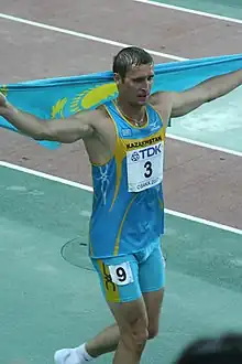
- Dmitriy Karpov, bronze medal-winning decathlon and heptathlon athlete (2004 Summer Olympics)
- Aleksei Grigorievich Stakhanov, Director of Number 31 mine (1943-1957) and Hero of the Soviet Union as a folk hero mine worker with 14 times quota production
- Pavel Vorobiev, professional ice hockey player
- Joseph Werth, Bishop of Transfiguration, Novosibirsk, Russia
- Anatoli Zarapin, Russian professional football coach and former player
See also
References
- "Назначен аким Караганды" (in Russian). 2023-01-18.
- "Численность населения Республики Казахстан по полу в разрезе областей, городов, районов, районных центров и поселков на начало 2020 года". Комитет по статистике Министерства национальной экономики Республики Казахстан (in Russian). Retrieved 2020-06-20.
- "Численность населения Республики Казахстан по полу в разрезе областей, городов, районов, районных центров и поселков на начало 2020 года". Комитет по статистике Министерства национальной экономики Республики Казахстан (in Russian). Retrieved 2020-06-20.
- "Население Республики Казахстан" [Population of the Republic of Kazakhstan] (in Russian). Департамент социальной и демографической статистики. Retrieved 8 December 2013.
- World's most polluted cities (historical data 2017-2021)
- "Очерки по истории города". Акимат Караганды (in Russian). Archived from the original on 2020-06-21. Retrieved 2020-06-20.
- Kennedy, Robert F. (1955, October 10). Lecture on Soviet Central Asia. Washington, DC: Georgetown University. In: Edwin O. Guthman and C. Richard Allen, RFK: His Words in Our Times' (pp.37-45). New York, New York: William Morrow.
- "Credible nuclear weapons capabilities and effects for real world peace: peace through tested, proved and practical declassified deterrence and countermeasures against collateral damage. Credible deterrence through simple, effective protection against concentrated and dispersed invasions and aerial attacks. Debunking inaccurate, misleading CND "disarm or be annihilated" left political anti-nuclear deterrence dogma. Hiroshima and Nagasaki anti-nuclear propaganda debunked by solid evidence". Retrieved Apr 14, 2019.
- "Bronze Age Couple Unearthed in Kazakhstan - Archaeology Magazine". www.archaeology.org. Retrieved 2019-08-17.
- Owen Jarus (August 2019). "This Young Man and Woman Were Buried Face-to-Face 4,000 Years Ago in Kazakhstan". livescience.com. Retrieved 2019-08-17.
- Ciaccia, Chris (2019-08-02). "Mysterious 4,000-year-old grave reveals boy and girl buried face to face". Fox News. Retrieved 2019-08-17.
- "M-43 Topographic Chart (in Russian)". Retrieved 10 February 2023.
- Google Earth
- "Weather and Climate - The Climate of Karaganda" (in Russian). Weather and Climate (Погода и климат). Archived from the original on 25 November 2016. Retrieved 3 January 2022.
- "Karaganda Climate Normals 1961-1990". National Oceanic and Atmospheric Administration. Retrieved 25 November 2016.
- "Памятник фразе "Где-где? В Караганде!" открыт в Казахстане". ria.ru. 2011-05-29.
- "Памятник жертвам голодомора открыли в Караганде". zonakz.net. 2022-05-31.