Kauhava
Kauhava is a town and municipality of Finland. It is part of the Southern Ostrobothnia region, 400 kilometres (250 mi) northwest of Helsinki and by the main railway from Helsinki to Oulu. The town has a population of 15,069 (26 October 2023)[2] and covers an area of 1,328.09 square kilometres (512.78 sq mi) of which 14.63 km2 (5.65 sq mi) is water.[1] The population density is 11.47 inhabitants per square kilometre (29.7/sq mi).
Kauhava | |
|---|---|
Town | |
| Kauhavan kaupunki Kauhava stad | |
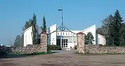 The Kauhava library | |
 Coat of arms | |
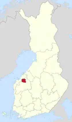 Location of Kauhava in Finland | |
| Coordinates: 63°06′N 023°04′E | |
| Country | |
| Region | Southern Ostrobothnia |
| Sub-region | Seinäjoki sub-region |
| Charter | 1867 |
| City rights | 1986 |
| Government | |
| • Town manager | Vesa Rantala |
| Area (2018-01-01)[1] | |
| • Total | 1,328.09 km2 (512.78 sq mi) |
| • Land | 1,313.74 km2 (507.24 sq mi) |
| • Water | 14.63 km2 (5.65 sq mi) |
| • Rank | 52nd largest in Finland |
| Population (2023-10-26)[2] | |
| • Total | 15,069 |
| • Rank | 75th largest in Finland |
| • Density | 11.47/km2 (29.7/sq mi) |
| Population by native language | |
| • Finnish | 96.1% (official) |
| • Swedish | 0.6% |
| • Others | 3.3% |
| Population by age | |
| • 0 to 14 | 15.3% |
| • 15 to 64 | 55.4% |
| • 65 or older | 29.4% |
| Time zone | UTC+02:00 (EET) |
| • Summer (DST) | UTC+03:00 (EEST) |
| Website | www.kauhava.fi |
The popular amusement park, PowerPark, is located in Alahärmä, Kauhava.[5]
The municipality is unilingually Finnish.
Geography
The surrounding country is flat and well suited to agriculture, alternating between fields and forests. The town probably takes its name from the small river which passes through it.
Climate
| Climate data for Kauhava Airfield (1991-2020 normals, records 1959-present) | |||||||||||||
|---|---|---|---|---|---|---|---|---|---|---|---|---|---|
| Month | Jan | Feb | Mar | Apr | May | Jun | Jul | Aug | Sep | Oct | Nov | Dec | Year |
| Record high °C (°F) | 9.1 (48.4) |
9.3 (48.7) |
14.7 (58.5) |
24.4 (75.9) |
29.6 (85.3) |
32.4 (90.3) |
33.0 (91.4) |
31.1 (88.0) |
27.3 (81.1) |
20.0 (68.0) |
13.0 (55.4) |
8.6 (47.5) |
33.0 (91.4) |
| Average high °C (°F) | −2.9 (26.8) |
−3.0 (26.6) |
1.6 (34.9) |
8.1 (46.6) |
15.0 (59.0) |
19.4 (66.9) |
22.1 (71.8) |
20.2 (68.4) |
14.6 (58.3) |
7.2 (45.0) |
2.0 (35.6) |
−1.0 (30.2) |
8.6 (47.5) |
| Daily mean °C (°F) | −6.3 (20.7) |
−6.8 (19.8) |
−2.9 (26.8) |
3.1 (37.6) |
9.1 (48.4) |
14.0 (57.2) |
16.6 (61.9) |
14.6 (58.3) |
9.7 (49.5) |
4.0 (39.2) |
−0.4 (31.3) |
−3.8 (25.2) |
4.2 (39.6) |
| Average low °C (°F) | −10.2 (13.6) |
−10.9 (12.4) |
−7.3 (18.9) |
−1.6 (29.1) |
3.0 (37.4) |
8.1 (46.6) |
11.0 (51.8) |
9.3 (48.7) |
5.2 (41.4) |
0.8 (33.4) |
−3.0 (26.6) |
−7.1 (19.2) |
−0.2 (31.6) |
| Record low °C (°F) | −37.6 (−35.7) |
−41.8 (−43.2) |
−31.4 (−24.5) |
−20.5 (−4.9) |
−8.3 (17.1) |
−3.1 (26.4) |
−1.2 (29.8) |
−3.1 (26.4) |
−8.7 (16.3) |
−22.6 (−8.7) |
−29.3 (−20.7) |
−37.2 (−35.0) |
−41.8 (−43.2) |
| Average precipitation mm (inches) | 31 (1.2) |
27 (1.1) |
24 (0.9) |
26 (1.0) |
40 (1.6) |
59 (2.3) |
69 (2.7) |
63 (2.5) |
53 (2.1) |
54 (2.1) |
45 (1.8) |
38 (1.5) |
529 (20.8) |
| Average precipitation days | 9 | 8 | 7 | 6 | 7 | 9 | 10 | 10 | 8 | 10 | 10 | 10 | 104 |
| Average relative humidity (%) | 90 | 88 | 80 | 72 | 66 | 68 | 74 | 79 | 84 | 89 | 92 | 92 | 81 |
| Source: https://helda.helsinki.fi/handle/10138/336063 | |||||||||||||
History
Kauhava was the home of the Finnish Training Air Wing from 1929 until the end of 2014.
The surrounding municipalities of Alahärmä, Kortesjärvi and Ylihärmä were consolidated with Kauhava on 1 January 2009.
Knife making
A traditional industry in Kauhava is knife making, and many Finns recognize the name of this small town because of knives made there. At one time, as many as five different knife-making enterprises were underway in the town, but today there is only one – Iisakki Järvenpää Oy, which has been making knives in Kauhava since 1879.
The puukko (one of the styles of Finnish knife) made in Kauhava are sometimes referred to as being in the Ostrobothnian style.
Each June sees the Kauhava International Knife Festival, lasting a couple of days and including knife exhibitions, knife making and knife throwing.
Museums
As with many Finnish localities, there are museums in Kauhava (Kauhava-Seura). One in the center of town features both the knifemaking tradition as well as the local textiles. An out-of-place fishing lure is one interesting feature of this museum. Another museum on the outskirts of Kauhava features the 19th century home and farm of Iisakin Jussi. It provides a view of late 19th century life in Western Finland. The Iisakin Jussi House is not open during the winter months.
International relations
Twin towns — Sister cities
Kauhava is twinned with:
 Rapla, Estonia
 Rygge, Norway
 Skærbæk, Denmark
 Vimmerby Municipality, Sweden
 Þorlákshöfn, Iceland
See also
- Finnish national road 19
- Jussi Pernaa, professional ice hockey player born in Kauhava
References
- "Area of Finnish Municipalities 1.1.2018" (PDF). National Land Survey of Finland. Retrieved 30 January 2018.
- "Preliminary population statistics 2023, September". StatFin. Statistics Finland. Retrieved 26 October 2023.
- "Demographic Structure by area as of 31 December 2022". Statistics Finland's PX-Web databases. Statistics Finland. Retrieved 6 September 2023.
- "Population according to age (1-year) and sex by area and the regional division of each statistical reference year, 2003–2020". StatFin. Statistics Finland. Retrieved 2 May 2021.
- PowerPark - Official website in English
