Kawaha Point
Kawaha Point is a suburb of Rotorua in the Bay of Plenty Region of New Zealand's North Island.
Kawaha Point | |
|---|---|
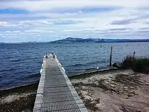
 A small jetty at the edge of Lake Rotorua | |
| Coordinates: 38.111349°S 176.236947°E | |
| Country | New Zealand |
| City | Rotorua |
| Local authority | Rotorua Lakes Council |
| Electoral ward | Te Ipu Wai Auraki General Ward |
| Area | |
| • Land | 103 ha (255 acres) |
| Population (June 2022)[2] | |
| • Total | 2,000 |
| Ngongotahā | (Lake Rotorua) | |
| Fairy Springs |
|
|
| Selwyn Heights | Koutu |
History
In 1910 the area was used for growing potatoes.[3] In 1917 a son of businessman and politician, Robert Gillies, Arthur William Gillies (1871[4]-1940),[5] started the development of Kawaha Point, when he offered an area for a hospital, on condition that the government improve the road.[4] A loan to improve the road was approved in 1924.[5] Land was sold in 1927[6] and more in 1929.[7] Initially development was only on the south side of the point.[8] The area to the north was built between about 1966[9] and 2000.[10]
Demographics
Kawaha statistical area, which corresponds to this suburb, covers 1.03 km2 (0.40 sq mi)[1] and had an estimated population of 2,000 as of June 2022,[2] with a population density of 1,942 people per km2.
| Year | Pop. | ±% p.a. |
|---|---|---|
| 2006 | 1,641 | — |
| 2013 | 1,773 | +1.11% |
| 2018 | 1,902 | +1.41% |
| Source: [11] | ||
Kawaha had a population of 1,902 at the 2018 New Zealand census, an increase of 129 people (7.3%) since the 2013 census, and an increase of 261 people (15.9%) since the 2006 census. There were 687 households, comprising 930 males and 975 females, giving a sex ratio of 0.95 males per female. The median age was 39.3 years (compared with 37.4 years nationally), with 411 people (21.6%) aged under 15 years, 333 (17.5%) aged 15 to 29, 846 (44.5%) aged 30 to 64, and 312 (16.4%) aged 65 or older.
Ethnicities were 66.1% European/Pākehā, 33.4% Māori, 7.3% Pacific peoples, 10.6% Asian, and 2.4% other ethnicities. People may identify with more than one ethnicity.
The percentage of people born overseas was 21.8, compared with 27.1% nationally.
Although some people chose not to answer the census's question about religious affiliation, 48.7% had no religion, 36.4% were Christian, 2.5% had Māori religious beliefs, 1.4% were Hindu, 0.5% were Muslim, 1.1% were Buddhist and 2.4% had other religions.
Of those at least 15 years old, 339 (22.7%) people had a bachelor's or higher degree, and 246 (16.5%) people had no formal qualifications. The median income was $31,200, compared with $31,800 nationally. 285 people (19.1%) earned over $70,000 compared to 17.2% nationally. The employment status of those at least 15 was that 741 (49.7%) people were employed full-time, 201 (13.5%) were part-time, and 87 (5.8%) were unemployed.[11]
Education
Kawaha Point School is a co-educational state primary school for Year 1 to 6 students,[12][13] with a roll of 230 as of April 2023.[14] The school teaches some classes in the Māori language.[15] The school opened in 1979.[16]
Transport
Kawaha has been served by a bus since at least 1943[17] and now has a half-hourly service.[18] Ngongotahā cycleway, which was opened in 2012,[19] runs to the west of Kawaha.[20]
References
- "ArcGIS Web Application". statsnz.maps.arcgis.com. Retrieved 26 December 2022.
- "Population estimate tables - NZ.Stat". Statistics New Zealand. Retrieved 25 October 2022.
- "OLD ROTORUA. EVENING POST". paperspast.natlib.govt.nz. 2 July 1910. Retrieved 14 August 2021.
- "Arthur William Gillies". geni_family_tree. Retrieved 13 August 2021.
- "OBITUARY. OTAGO DAILY TIMES". paperspast.natlib.govt.nz. 27 August 1940. Retrieved 13 August 2021.
- "AUCKLAND STAR". paperspast.natlib.govt.nz. 7 April 1927. Retrieved 14 August 2021.
- "NEW ZEALAND HERALD". paperspast.natlib.govt.nz. 9 March 1929. Retrieved 14 August 2021.
- "1:63360 map Sheet: N76 Rotorua". www.mapspast.org.nz. 1952. Retrieved 14 August 2021.
- "Survey: SN1906 Run: 5232 Photo: 7". Retrolens. 15 October 1966.
- "Survey: SN9445 Run: E Photo: 29". Retrolens. 11 March 1996.
- "Statistical area 1 dataset for 2018 Census". Statistics New Zealand. March 2020. Kawaha (198800). 2018 Census place summary: Kawaha
- "Official School Website". kawaha-point.school.nz.
- "Ministry of Education School Profile". educationcounts.govt.nz. Ministry of Education.
- "Education Review Office Report". ero.govt.nz. Education Review Office.
- "Welcome to Kawaha Point School". Kawaha Point School. Retrieved 19 December 2020.
- Bramwell, Chris (18 November 2004). "Kawaha Point School turns 25". Rotorua Daily Post.
- "NEW ZEALAND HERALD". paperspast.natlib.govt.nz. 11 February 1943. Retrieved 14 August 2021.
- "Rotorua CityRide Route 6 - Kawaha Point via Rotorua Hospital". www.baybus.co.nz. Retrieved 14 August 2021.
- "Cycleways". www.rotorualakescouncil.nz. Retrieved 14 August 2021.
- "CYWAY PROJECT UPDATE" (PDF). 8 November 2017.