Kazlų Rūda Municipality
Kazlų Rūda Municipality is one of 60 municipalities in Lithuania.
Kazlų Rūda Municipality
Kazlų Rūdos savivaldybė | |
|---|---|
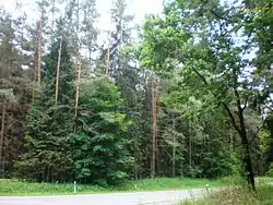
 Kazlų Rūda forests | |
.svg.png.webp) Coat of arms | |
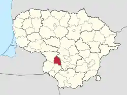
 Location of Kazlų Rūda municipality within Lithuania | |
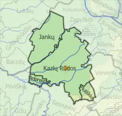
 Map of Kazlų Rūda municipality | |
| Country | |
| Ethnographic region | Suvalkija |
| County | |
| Capital | Kazlų Rūda |
| Elderships | 4 |
| Area | |
| • Total | 555 km2 (214 sq mi) |
| • Rank | 46th |
| Population | |
| • Total | 11,054 |
| • Rank | 55th |
| • Density | 20/km2 (52/sq mi) |
| • Rank | 38th |
| Time zone | UTC+2 (EET) |
| • Summer (DST) | UTC+3 (EEST) |
| Telephone code | 343 |
| Major settlements |
|
| Website | www |
Elderships
Kazlų Rūda Municipality is divided into 4 elderships:[3]
| Eldership (Administrative Center) | Area | Population (2021) |
|---|---|---|
| 19 km2 (4,695.00 acres; 7.34 sq mi) | 693 | |
| 169 km2 (41,760.81 acres; 65.25 sq mi) | 904 | |
| 360 km2 (88,957.94 acres; 139.00 sq mi) | 3,282 | |
| 30 km2 (7,413.16 acres; 11.58 sq mi) | 585 |
References
- "Gyventojai gyvenamosiose vietovese". Archived from the original on 2022-03-07. Retrieved 2022-12-09.
- "Home". kazluruda.lt.
- "Kazlų Rūda | Kazlų Rūdos savivaldybė". Kazlų Rūda | Kazlų Rūdos savivaldybė (in Lithuanian). Retrieved 2022-07-08.
This article is issued from Wikipedia. The text is licensed under Creative Commons - Attribution - Sharealike. Additional terms may apply for the media files.
