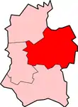
Kennet District
| Kennet District | |
|---|---|
 Shown within non-metropolitan Wiltshire | |
| Geography | |
| Status: | District |
| Region: | South West England |
| Admin. County: | Wiltshire |
| Area: - Total | Ranked 28th 966.62 km² |
| Admin. HQ: | Devizes |
| ONS code: | 46UB |
| Demographics | |
| Ethnicity: | 96.7% White 1.0% S.Asian 1.0% Mixed Race 0.6% Black 0.7% Chinese or other |
| Politics | |
| Kennet District Council | |
| Leadership: | Alternative - Sec.31 |
Kennet was a non-metropolitan local government district in Wiltshire, England, abolished as part of the 2009 structural changes to local government. It was named after the River Kennet.
The district was formed on 1 April 1974, under the Local Government Act 1972, by a merger of the municipal boroughs of Devizes and Marlborough, alongside Devizes Rural District, Marlborough and Ramsbury Rural District and Pewsey Rural District.
The district council was based at offices in Devizes. It was abolished on 1 April 2009 as part of the structural changes to local government in England, when its functions were taken over by the new Wiltshire Council unitary authority.
This article is issued from Wikipedia. The text is licensed under Creative Commons - Attribution - Sharealike. Additional terms may apply for the media files.
.png.webp)
.png.webp)
.png.webp)
.png.webp)
.png.webp)
.png.webp)
.png.webp)