Kensington, Western Australia
Kensington is a residential suburb 3 km from Perth's central business district. Kensington is located within the City of South Perth and Town of Victoria Park local government areas.
| Kensington Perth, Western Australia | |||||||||||||||
|---|---|---|---|---|---|---|---|---|---|---|---|---|---|---|---|
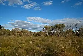 Kensington Bushland | |||||||||||||||
| Coordinates | 31.9825°S 115.884444°E | ||||||||||||||
| Population | 4,627 (SAL 2021)[1] | ||||||||||||||
| Postcode(s) | 6151 | ||||||||||||||
| Area | 2.5 km2 (0.97 sq mi) | ||||||||||||||
| Location | 3 km (2 mi) from Perth | ||||||||||||||
| LGA(s) | |||||||||||||||
| State electorate(s) | South Perth, Victoria Park | ||||||||||||||
| Federal division(s) | Swan | ||||||||||||||
| |||||||||||||||
The suburb is bounded by Canning Highway to the west, Berwick Street to the north, Kent Street to the east, and Hayman Road and South Terrace to the south.
The suburb was named after the Kensington Park racecourse which, in turn, was most likely named after the prestigious London suburb of Kensington.[2]
Kensington also has a very popular cafe, located opposite Kensington Primary School, The Little Banksia.[3]
Senior and tertiary education
Kensington contains Kensington Primary School.
References
- Australian Bureau of Statistics (28 June 2022). "Kensington (WA) (Suburb and Locality)". Australian Census 2021 QuickStats. Retrieved 28 June 2022.
- "History of metropolitan suburb names – K". Western Australian Land Information Authority. Archived from the original on 16 March 2022. Retrieved 12 December 2022.
- https://thelittlebanksia.com.au
This article is issued from Wikipedia. The text is licensed under Creative Commons - Attribution - Sharealike. Additional terms may apply for the media files.