Kfar Hess
Kfar Hess (Hebrew: כְּפַר הֶס, lit. 'Hess Village') is a moshav in central Israel. Located in the Sharon plain to the south-east of Tel Mond and covering 3,800 dunams, located 262.5 feet (80.0 meters) above sea level and it falls under the jurisdiction of Lev HaSharon Regional Council (formerly Hadar HaSharon).[2] In 2021 it had a population of 1,583.[1]
Kfar Hess
כְּפַר הֶס | |
|---|---|
 | |
 Kfar Hess  Kfar Hess | |
| Coordinates: 32°14′47″N 34°56′5″E | |
| Country | Israel |
| District | Central |
| Council | Lev HaSharon |
| Affiliation | Moshavim Movement |
| Founded | 1931 |
| Population (2021)[1] | 1,583 |
| Website | www.kfar-hess.co.il |
History
Before the 20th century the area formed part of the Forest of Sharon. It was an open woodland dominated by Mount Tabor Oak, which extended from Kfar Yona in the north to Ra'anana in the south. The local Arab inhabitants traditionally used the area for pasture, firewood and intermittent cultivation. The intensification of settlement and agriculture in the coastal plain during the 19th century led to deforestation and subsequent environmental degradation.[3]
The village was founded in 1931 as part of the Settlement of the Thousand, and together with Herut, Ein Vered, Tel Mond and Kfar Ziv, it formed part of Gush Tel Mond (lit. Tel Mond Bloc). It was named after Moses Hess, a secular Jewish philosopher and one of the founders of socialism and Labour Zionist thought.
The founding group was organized under the Izrael organization, that was meant to settle in lands bought from the village Zarin in the outskirts of the Jezreel Valley, near Kfar Yehezkel. The idea for creating the new organization was conceived by the agricultural workers and Zionist pioneers, Nisan Boord and Mordechai Te'eni.
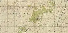
 Kfar Hess 1937
 Kfar Hess (Kefar Hess) 1942 1:20,000
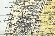
 Kfar Hess (Kefar Hess) 1945 1:250,000
Notable residents
References
- "Regional Statistics". Israel Central Bureau of Statistics. Retrieved 22 February 2023.
- "אודות המועצה האזורית לב השרון". www.lev-hasharon.com (in Hebrew). Retrieved 2022-10-17.
- Marom, Roy (2022-12-01). "The Oak Forest of the Sharon (al-Ghaba) in the Ottoman Period: New Insights from Historical- Geographical Studies". Muse. 5: 90–107.