Khan Chroy Changvar
Chroy Changvar (Khmer: ជ្រោយចង្វារ) is a satellite city in Phnom Penh, Cambodia.
Chroy Changvar
ជ្រោយចង្វារ | |
|---|---|
Satellite city | |
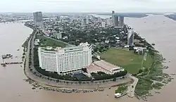 High-rise buildings in Chroy Changvar district | |
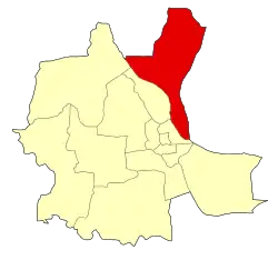 Location of Chroy Changvar within Phnom Penh | |
| Coordinates: 11°32′36.246″N 104°55′26.793″E | |
| Country | Cambodia |
| City | Phnom Penh |
| Area | |
| • Total | 85.5 km2 (33.0 sq mi) |
| Population (2019)[1] | |
| • Total | 159,233 |
| Time zone | UTC+7 (ICT) |
Administration
Chroy Changvar is subdivided into 5 Sangkats and 22 Phums.[2][3]
| Sangkat (communes) | Phum (villages) |
|---|---|
| Prek Leap | Kien Khleang, Prek Leap, Bak Khaeng, Khtor |
| Prek Ta Sek | Prek Ta Roatn, Prek Ta Kong, Prek Reang, Prek Ta Sek, Daeum Kor |
| Chroy Changvar | Phum I, Phum II, Phum III, Daeum Kor, Kien Khleang |
| Bak Khaeng | Bak Khaeng Leu, Kdei Chas, Chambak Meas |
| Koh Dach | Chong Koh, Lvear, Kbal Koh, Koh Dach, Roneah |
References
- "General Population Census of the Kingdom of Cambodia 2019 – Final Results" (PDF). National Institute of Statistics. Ministry of Planning. 26 January 2021. Retrieved 3 February 2021.
- "Map 12. Administrative Areas in Phnom Penh Municipality by District and Commune" (PDF). National Institute of Statistics, Ministry of Planning (Cambodia). 2013-12-31.
- Jendhamuni (28 December 2013). "Khmerization: New districts signed into being by PM". khmerization.blogspot.com.
| Autonomous municipality |
| ||
|---|---|---|---|
| Provinces | |||
This article is issued from Wikipedia. The text is licensed under Creative Commons - Attribution - Sharealike. Additional terms may apply for the media files.