Khibiny National Park
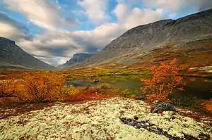
Khibiny National Park (Russian: Национальный парк «Хибины») protects a mountainous region of taiga and tundra on the Khibiny Mountains and Lovozero Massif of the western Kola Peninsula in northwestern Russia.[1] The mountains contain commercially important minerals, and the park's borders reflect the need to balance three uses - protection of the unique natural environment, recreation (hiking in the summer, skiing in the winter), and industrial mining. The park was officially created in 2018,[2] and is located in the districts of Kirovsk and Olenegorsk in Murmansk Oblast. [3] [4]
| Khibiny National Park | |
|---|---|
| (Russian: Хибины) | |
 Khibiny National Park | |
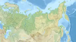
 Location of Park | |
| Location | Murmansk Oblast |
| Nearest city | Kandalaksha |
| Coordinates | 67°43′N 33°28′E |
| Area | 84,804 hectares (209,555 acres; 848 km2; 327 sq mi) |
| Established | December 2018 |
| Governing body | FGBU "Khibiny " |
Topography
Surrounded by low plains, the varied terrain of the mountains supports high biodiversity. The mountain range itself is a circle about 40 km across, with Lake Imandra on the western border, and Lake Umbozero on the eastern. The park has two sections - a west sector and east sector of approximately equal size and central valley corridor that is not in the protected zone.[5] Across Lake Imandra to the west is the Lapland Biosphere Reserve. Elevations in the park range from 130 to 1,196 meters.[3]
Ecoregion and climate
The park is at the northern edge of the Scandinavian and Russian taiga ecoregion, only a few kilometers south of the official transition to the Kola Peninsula tundra ecoregion.[6]
The climate of the ecoregion is Subarctic climate, without dry season (Köppen climate classification Subarctic climate (Dfc)). This climate is characterized by mild summers (only 1-3 months above 10 °C (50.0 °F)) and cold, snowy winters (coldest month below −3 °C (26.6 °F)).[7][8]
| Kandalaksha, Russia | ||||||||||||||||||||||||||||||||||||||||||||||||||||||||||||
|---|---|---|---|---|---|---|---|---|---|---|---|---|---|---|---|---|---|---|---|---|---|---|---|---|---|---|---|---|---|---|---|---|---|---|---|---|---|---|---|---|---|---|---|---|---|---|---|---|---|---|---|---|---|---|---|---|---|---|---|---|
| Climate chart (explanation) | ||||||||||||||||||||||||||||||||||||||||||||||||||||||||||||
| ||||||||||||||||||||||||||||||||||||||||||||||||||||||||||||
| ||||||||||||||||||||||||||||||||||||||||||||||||||||||||||||
Plants and animals
Ground cover in the park is 62% grassland, 27% forest, 8% bare rock, and the remaining 3% shrub cover or water.[3] Species diversity is high, as there are different altitude zones, different landform types, and mixing of species in the transition zone between Arctic and taiga flora zones.[5]
See also
References
- "Khibiny (Republic of Karelia)". World Wildlife Federation (Russia). Retrieved December 9, 2021.
- "On the creation of the Khibiny National Park". Russian Federation. Retrieved December 9, 2021.
- "Hibiny National Park". Digital Observatory for Protected Areas. Retrieved December 9, 2021.
- "Khibiny National Park" (in Russian). ecopetersburg. Retrieved December 18, 2021.
- "Khibiny National Park". Nature Russia.
- "Map of Ecoregions 2017". Resolve, using WWF data. Retrieved September 14, 2019.
- Kottek, M., J. Grieser, C. Beck, B. Rudolf, and F. Rubel, 2006. "World Map of Koppen-Geiger Climate Classification Updated" (PDF). Gebrüder Borntraeger 2006. Retrieved September 14, 2019.
{{cite web}}: CS1 maint: multiple names: authors list (link) - "Dataset - Koppen climate classifications". World Bank. Retrieved September 14, 2019.
