Khishniyah
Khishniyah (Arabic: الخشنية) is a depopulated village near Al-Rafid in Quneitra Governorate, Syria.
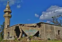
Destroyed Mosque in Khishniyah, Golan Heights
Khishniyah
الخشنية חושניה | |
|---|---|
Village | |
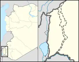 Khishniyah The Golan on the map of Syria; Khishniyah on the map of the Golan. | |
| Coordinates: 32°59′56″N 35°48′40″E | |
| Country | Golan Heights, internationally recognized as Syrian territory occupied by Israel |
| Israeli District | Northern District |
| Israeli Subdistrict | Golan |
| Syrian Governorate | Quneitra Governorate |
| Syrian District | Quneitra District |
| Syrian Subdistrict | al-Khisniyah |
| Destroyed | June 10, 1967 |
| Population (1960) | |
| • Total | 1,136[1] |
References
- Kipnis, Yigal (2013). The Golan Heights: Political History, Settlement and Geography since 1949. London and New York: Routledge. p. 245. ISBN 978-1-136-74092-3.
| Quneitra District |
| ||||||||
|---|---|---|---|---|---|---|---|---|---|
| Fiq District |
| ||||||||
| Israeli settlements in the Israeli-occupied Golan Heights |
| ||||||||
| Syrian localities in Israeli-occupied Golan Heights |
| ||||||||
Israeli settlements in italics were on the Mandatory Palestine side of the 1923 border. | |||||||||
This article is issued from Wikipedia. The text is licensed under Creative Commons - Attribution - Sharealike. Additional terms may apply for the media files.