Meshginshahr
Meshginshahr (Persian: مشگين شهر, also Romanized as Meshgīn Shahr; also known as Meshkīn Shahr or simply Mishgin; formerly Khiav (Persian: خياو), also Romanized as Kheyāv, Khīāv, Khiov, Khīyāv, and Khiyov)[3] is a city in the Central District of Meshgin Shahr County, Ardabil province, Iran, and serves as the county's capital.
Meshgin Shahr
Persian: مشگين شهر | |
|---|---|
City | |
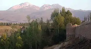 Arshoq Castle, a.k.a. Kohneh Qaleh ("old castle"), in Meshgin Shahr; Mount Sabalan is in the background | |
 Meshgin Shahr | |
| Coordinates: 38°23′50″N 47°40′26″E[1] | |
| Country | Iran |
| Province | Ardabil |
| County | Meshgin Shahr |
| District | Central |
| Area | |
| • Total | 12 km2 (5 sq mi) |
| Population (2016)[2] | |
| • Total | 74,109 |
| • Density | 6,200/km2 (16,000/sq mi) |
| Time zone | UTC+3:30 (IRST) |
| Website | www |
| Meshginshahr at GEOnet Names Server | |

At the 2006 census, its population was 61,296 in 14,920 households.[4] The following census in 2011 counted 66,883 people in 17,871 households.[5] The latest census in 2016 showed a population of 74,109 people in 21,926 households.[2]
History
The 14th-century author Hamdallah Mustawfi mentioned the city, as Khiyāv, as one of the seven cities in the tuman of Pishkin, or Mishkin.[6] He distinguished between the cities of Khiyav and Pishkin — according to him, Khiyav lay to the south of Mount Sablan and had a warm climate, while Pishkin (which he said had formerly been called "Varāvī") was to the north of Mount Sablan and had a damp climate because the mountain shielded it from the sun.[6] Both cities drew their water from the streams coming down from the mountain.[6] The district of Pishkin, he wrote, grew both grain and fruit in abundance, while Khiyav mostly grew grain.[6] Pishkin was assessed for a tax value of 5,200 dinars, while Khiyav was assessed at 2,000.[6] Mustawfi wrote that Pishkin's population was mostly Shafi'i Sunnis, with Shi'i and Hanafi Sunni minorities.[6] He said nothing about Khiyav's religious makeup, but instead described its population as mostly "boot-makers and cloth-workers".[6]
References
- OpenStreetMap contributors (28 March 2023). "Meshginshahr, Meshgin Shahr County" (Map). OpenStreetMap. Retrieved 28 March 2023.
- "Census of the Islamic Republic of Iran, 1395 (2016)". AMAR (in Persian). The Statistical Center of Iran. p. 24. Archived from the original (Excel) on 22 March 2019. Retrieved 19 December 2022.
- Meshginshahr can be found at GEOnet Names Server, at this link, by opening the Advanced Search box, entering "-3074756" in the "Unique Feature Id" form, and clicking on "Search Database".
- "Census of the Islamic Republic of Iran, 1385 (2006)". AMAR (in Persian). The Statistical Center of Iran. p. 24. Archived from the original (Excel) on 20 September 2011. Retrieved 25 September 2022.
- "Census of the Islamic Republic of Iran, 1390 (2011)" (Excel). Iran Data Portal (in Persian). The Statistical Center of Iran. p. 24. Retrieved 19 December 2022.
- Hamdallah Mustawfi (1919). Le Strange, Guy (ed.). The Geographical Part of the Nuzhat-al-Qulub. p. 85. Retrieved 10 October 2022.
Sources
External links
- Meshgin Shahr Tourism Website
- Meshgin Shahr Municipality Website
- Meshgin Shahr Government Website
- Meshgin Shahr Travel Guide
| Capital | 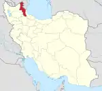 | ||||||||||||||||||||||
|---|---|---|---|---|---|---|---|---|---|---|---|---|---|---|---|---|---|---|---|---|---|---|---|
| Counties and cities |
| ||||||||||||||||||||||
| Landmarks |
| ||||||||||||||||||||||
| Places | |||||||||||||||||||||||