Kimberley, Queensland
Kimberley is a coastal locality in the Shire of Douglas, Queensland, Australia.[2] In the 2021 census, Kimberley had a population of 28 people.[3]
| Kimberley Queensland | |||||||||||||||
|---|---|---|---|---|---|---|---|---|---|---|---|---|---|---|---|
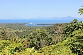 View from the Walu Wugirriga Lookout to the mouth of the Daintree River | |||||||||||||||
 Kimberley | |||||||||||||||
| Coordinates | 16.2747°S 145.4575°E | ||||||||||||||
| Population | 28 (SAL 2021)[1] | ||||||||||||||
| Postcode(s) | 4873 | ||||||||||||||
| Area | 58.3 km2 (22.5 sq mi) | ||||||||||||||
| Time zone | AEST (UTC+10:00) | ||||||||||||||
| LGA(s) | Shire of Douglas | ||||||||||||||
| State electorate(s) | Cook | ||||||||||||||
| Federal division(s) | Leichhardt | ||||||||||||||
| |||||||||||||||
Geography
The locality is bounded to the south by the Daintree River and to the south-east, east, and north-east by the Coral Sea.[4]
Cape Tribulation Road enters the locality from the west (Forest Creek) and meanders through the centre of the locality and then exits to the north-west (Cow Bay).[4]
Much of the locality is within the Daintree National Park. Other land use includes grazing on native vegetation and horticulture.[4]
History
The locality takes its name from Cape Kimberley, which in turn was named on 24 October 1873 after John Wodehouse, First Earl of Kimberley (Secretary of State for the Colonies) by explorer George Elphinstone Dalrymple.[2][5]
In the 2016 census, Kimberley had a population of 33 people.[6]
In the 2021 census, Kimberley had a population of 28 people.[3]
Attractions
Walu Wugirriga Lookout (also known as Mount Alexandra Lookout) is on Cape Tribulation Road (16.2458°S 145.4362°E).[7] It provides views across the mouth of the Daintree River and beyond to Snapper Island and the Low Isles.[8]
References
- Australian Bureau of Statistics (28 June 2022). "Kimberley (Qld) (Suburb and Locality)". Australian Census 2021 QuickStats. Retrieved 28 June 2022.
- "Kimberley – locality in Shire of Douglas (entry 48702)". Queensland Place Names. Queensland Government. Retrieved 24 May 2019.
- Australian Bureau of Statistics (28 June 2022). "Kimberley (SAL)". 2021 Census QuickStats. Retrieved 28 February 2023.
- "Queensland Globe". State of Queensland. Retrieved 11 June 2023.
- "Cape Kimberley – cape in the Douglas Shire (entry 18152)". Queensland Place Names. Queensland Government. Retrieved 4 June 2019.
- Australian Bureau of Statistics (27 June 2017). "Kimberley (SSC)". 2016 Census QuickStats. Retrieved 20 October 2018.
- "Tourist points - Queensland". Queensland Open Data. Queensland Government. 18 November 2020. Archived from the original on 24 November 2020. Retrieved 24 November 2020.
- "Mount Alexandra lookout, Cape Tribulation | Daintree National Park (CYPAL)". Parks and forests. Queensland Government. 21 April 2017. Retrieved 11 June 2023.