Klepp
Klepp is a municipality in Rogaland county, Norway. It is located in the traditional district of Jæren. The administrative centre of the municipality is the village of Kleppe. Other villages in Klepp include Klepp stasjon, Orre, Orstad, Pollestad, Verdalen, and Voll.[3] Klepp is a flat and open agricultural landscape. The highest point, Tinghaug, is at 102 metres (335 ft) above sea level. There are long stretches of sand beaches along the North Sea coastline in the west.[3]
Klepp kommune
Klep herred (historic) | |
|---|---|
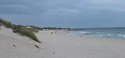 View of the Orrestranda beach along the Klepp coast | |
 Flag  Rogaland within Norway | |
 Klepp within Rogaland | |
| Coordinates: 58°46′38″N 05°35′48″E | |
| Country | Norway |
| County | Rogaland |
| District | Jæren |
| Established | 1 Jan 1838 |
| • Created as | Formannskapsdistrikt |
| Administrative centre | Kleppe |
| Government | |
| • Mayor (2019) | Sigmund Rolfsen (Ap) |
| Area | |
| • Total | 113.49 km2 (43.82 sq mi) |
| • Land | 102.36 km2 (39.52 sq mi) |
| • Water | 11.13 km2 (4.30 sq mi) 9.8% |
| • Rank | #324 in Norway |
| Population (2022) | |
| • Total | 20,163 |
| • Rank | #63 in Norway |
| • Density | 197/km2 (510/sq mi) |
| • Change (10 years) | |
| Demonym | Kleppsbu[1] |
| Official language | |
| • Norwegian form | Nynorsk |
| Time zone | UTC+01:00 (CET) |
| • Summer (DST) | UTC+02:00 (CEST) |
| ISO 3166 code | NO-1120 |
| Website | Official website |

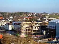
The 113-square-kilometre (44 sq mi) municipality is the 324th largest by area out of the 356 municipalities in Norway. Klepp is the 63rd most populous municipality in Norway with a population of 20,163. The municipality's population density is 197 inhabitants per square kilometre (510/sq mi) and its population has increased by 13.6% over the previous 10-year period.[4][5] The population around Kleppe is growing rapidly, mostly in the form of suburban single-family homes, but also in the form of some apartment blocks. There is a shopping mall in Kleppe called Jærhagen.
General information
The old parish of Klep was established as a municipality on 1 January 1838 (see formannskapsdistrikt law). The boundaries of the municipality have not changed since that time.[6]
Name
The municipality (originally the parish) is named after the old Klepp farm (Old Norse: Kleppi) since the first Klepp Church was built there. The name is the dative case of the word kleppr which means "rocky hill". The inscription on the Klepp I Runestone indicates that the name has been in use since the late 10th or early 11th century. Before 1912, the name was written "Klep".[7]
Coat of arms
The coat of arms was granted on 18 February 1972. The official blazon is "Azure, a Cossack cross Or" (Norwegian: På blå botn ein svevande, utskrådd gul kross). This means the arms have a blue field (background) and the charge is a Cossack cross. The charge has a tincture of Or which means it is commonly colored yellow, but if it is made out of metal, then gold is used. The cross on the arms symbolizes the large stone cross at Krosshaug in Klepp. Krosshaug is a grave hill located near the site where the local thing met for centuries. The Old Norse word haugr means "mound", hence the name "kross-haug" is the cross-mound. The cross was considered a representative historic symbol for the municipality. The municipal flag has the same design as the coat of arms.[8][9][10]
Churches
The Church of Norway has four parishes (sokn) within the municipality of Klepp. It is part of the Jæren prosti (deanery) in the Diocese of Stavanger.
| Parish (sokn) | Church name | Location of the church | Year built |
|---|---|---|---|
| Bore | Bore Church | Bore | 1891 |
| Frøyland og Orstad** | Frøyland og Orstad Church | Orstad | 2008 |
| Klepp | Klepp Church | Kleppe | 1846 |
| Orre | Orre Church | Pollestad | 1950 |
| Old Orre Church | Orre | c. 1250 | |
| **Note: Frøyland og Orstad parish covers part of Klepp municipality and part of Time municipality. | |||
History
The earliest traces of population in the municipality have been dated to around 6000 BC. At that time, the land was covered by large oak woods. The large stone cross standing on the grave hill Krosshaug dates from around 1000 AD and is possibly the oldest in Norway. It is adjacent to Tinghaug, the site for a local Thing for many centuries during the Iron Age. Tinghaug probably acted as a site for the local court and assembly for many centuries.
Population
|
|
| ||||||||||||||||||||||||||||||||||||||||||||||||||||||||||||||||||
| Source: Statistics Norway[11][12] and Norwegian Historical Data Centre[13] | ||||||||||||||||||||||||||||||||||||||||||||||||||||||||||||||||||||
Geography
The municipality is located 25 kilometres (16 mi) south of the city of Stavanger. Neighbouring municipalities are Hå to the south, Time to the south and east, Sola and Sandnes to the north. The coastline is agricultural and consists of, from south to north, the areas Orre, Reve, Bore and Sele.
The long Orrestranda beach, one of the longest sandy beaches in Norway, is in Klepp. The river Figgjoelva empties into the North Sea in Klepp. The small island of Feistein lies off shore and is the site of the Feistein Lighthouse. There are two large lakes in Klepp: Orrevatnet and Frøylandsvatnet.
Weather
| Climate data for Klepp | |||||||||||||
|---|---|---|---|---|---|---|---|---|---|---|---|---|---|
| Month | Jan | Feb | Mar | Apr | May | Jun | Jul | Aug | Sep | Oct | Nov | Dec | Year |
| Daily mean °C (°F) | 0.6 (33.1) |
0.4 (32.7) |
2.6 (36.7) |
5.5 (41.9) |
9.8 (49.6) |
12.7 (54.9) |
14 (57) |
14.2 (57.6) |
11.7 (53.1) |
8.6 (47.5) |
4.5 (40.1) |
2.1 (35.8) |
7.2 (45.0) |
| Average precipitation mm (inches) | 102 (4.0) |
71 (2.8) |
79 (3.1) |
58 (2.3) |
68 (2.7) |
74 (2.9) |
97 (3.8) |
123 (4.8) |
158 (6.2) |
158 (6.2) |
150 (5.9) |
125 (4.9) |
1,260 (49.6) |
| Source: Norwegian Meteorological Institute[14] | |||||||||||||
Transportation
The Sørlandet railway line, historically called the Jæren Line, runs through Klepp along lake Frøylandsvatnet. The village of Klepp stasjon, 3 kilometres (1.9 mi) east of Kleppe, is built around the train station Klepp Station. The nearby Oksnevadporten Station is the other railway station in Klepp.
Economy
Klepp is the second largest agricultural municipality in Rogaland, with a total of around 600 farms. Kverneland Group, located in Kvernaland, is the largest manufacturer of agricultural equipment in the world.
Sports
The local sports club Klepp IL most notably has a women's football team in the Norwegian top league. Famous players include Dagny Mellgren and the national team captain Ane Stangeland Horpestad. Gymnast Åge Storhaug also represented the club.
Government
All municipalities in Norway are responsible for primary education (through 10th grade), outpatient health services, senior citizen services, welfare and other social services, zoning, economic development, and municipal roads and utilities. The municipality is governed by a municipal council of directly elected representatives. The mayor is indirectly elected by a vote of the municipal council.[15] The municipality is under the jurisdiction of the Sør-Rogaland District Court and the Gulating Court of Appeal.
Municipal council
The municipal council (Kommunestyre) of Klepp is made up of 31 representatives that are elected to four year terms. Currently, the party breakdown is as follows:
| Party Name (in Nynorsk) | Number of representatives | |
|---|---|---|
| Labour Party (Arbeidarpartiet) | 4 | |
| People's Action No to More Road Tolls (Folkeaksjonen nei til meir bompengar) | 2 | |
| Progress Party (Framstegspartiet) | 7 | |
| Green Party (Miljøpartiet Dei Grøne) | 1 | |
| Conservative Party (Høgre) | 7 | |
| Christian Democratic Party (Kristeleg Folkeparti) | 4 | |
| Centre Party (Senterpartiet) | 5 | |
| Socialist Left Party (Sosialistisk Venstreparti) | 1 | |
| Total number of members: | 31 | |
| Party Name (in Nynorsk) | Number of representatives | |
|---|---|---|
| Labour Party (Arbeidarpartiet) | 5 | |
| Progress Party (Framstegspartiet) | 6 | |
| Green Party (Miljøpartiet Dei Grøne) | 1 | |
| Conservative Party (Høgre) | 9 | |
| Christian Democratic Party (Kristeleg Folkeparti) | 5 | |
| Centre Party (Senterpartiet) | 4 | |
| Liberal Party (Venstre) | 1 | |
| Total number of members: | 31 | |
| Party Name (in Nynorsk) | Number of representatives | |
|---|---|---|
| Labour Party (Arbeidarpartiet) | 5 | |
| Progress Party (Framstegspartiet) | 6 | |
| Conservative Party (Høgre) | 11 | |
| Christian Democratic Party (Kristeleg Folkeparti) | 5 | |
| Centre Party (Senterpartiet) | 3 | |
| Liberal Party (Venstre) | 1 | |
| Total number of members: | 31 | |
| Party Name (in Nynorsk) | Number of representatives | |
|---|---|---|
| Labour Party (Arbeidarpartiet) | 4 | |
| Progress Party (Framstegspartiet) | 7 | |
| Conservative Party (Høgre) | 8 | |
| Christian Democratic Party (Kristeleg Folkeparti) | 5 | |
| Centre Party (Senterpartiet) | 4 | |
| Socialist Left Party (Sosialistisk Venstreparti) | 1 | |
| Liberal Party (Venstre) | 2 | |
| Total number of members: | 31 | |
| Party Name (in Nynorsk) | Number of representatives | |
|---|---|---|
| Labour Party (Arbeidarpartiet) | 4 | |
| Progress Party (Framstegspartiet) | 8 | |
| Conservative Party (Høgre) | 7 | |
| Christian Democratic Party (Kristeleg Folkeparti) | 4 | |
| Centre Party (Senterpartiet) | 5 | |
| Socialist Left Party (Sosialistisk Venstreparti) | 2 | |
| Liberal Party (Venstre) | 1 | |
| Total number of members: | 31 | |
| Party Name (in Nynorsk) | Number of representatives | |
|---|---|---|
| Labour Party (Arbeidarpartiet) | 4 | |
| Progress Party (Framstegspartiet) | 7 | |
| Conservative Party (Høgre) | 8 | |
| Christian Democratic Party (Kristeleg Folkeparti) | 7 | |
| Centre Party (Senterpartiet) | 6 | |
| Socialist Left Party (Sosialistisk Venstreparti) | 1 | |
| Liberal Party (Venstre) | 2 | |
| Total number of members: | 35 | |
| Party Name (in Nynorsk) | Number of representatives | |
|---|---|---|
| Labour Party (Arbeidarpartiet) | 5 | |
| Progress Party (Framstegspartiet) | 5 | |
| Conservative Party (Høgre) | 6 | |
| Christian Democratic Party (Kristeleg Folkeparti) | 5 | |
| Centre Party (Senterpartiet) | 11 | |
| Socialist Left Party (Sosialistisk Venstreparti) | 1 | |
| Liberal Party (Venstre) | 2 | |
| Total number of members: | 35 | |
| Party Name (in Nynorsk) | Number of representatives | |
|---|---|---|
| Labour Party (Arbeidarpartiet) | 4 | |
| Progress Party (Framstegspartiet) | 3 | |
| Conservative Party (Høgre) | 8 | |
| Christian Democratic Party (Kristeleg Folkeparti) | 6 | |
| Centre Party (Senterpartiet) | 11 | |
| Socialist Left Party (Sosialistisk Venstreparti) | 2 | |
| Liberal Party (Venstre) | 1 | |
| Total number of members: | 35 | |
| Party Name (in Nynorsk) | Number of representatives | |
|---|---|---|
| Labour Party (Arbeidarpartiet) | 7 | |
| Progress Party (Framstegspartiet) | 4 | |
| Conservative Party (Høgre) | 10 | |
| Christian Democratic Party (Kristeleg Folkeparti) | 6 | |
| Centre Party (Senterpartiet) | 6 | |
| Joint list of the Liberal Party (Venstre) and Liberal People's Party (Liberale Folkepartiet) |
2 | |
| Total number of members: | 35 | |
| Party Name (in Nynorsk) | Number of representatives | |
|---|---|---|
| Labour Party (Arbeidarpartiet) | 6 | |
| Progress Party (Framstegspartiet) | 4 | |
| Conservative Party (Høgre) | 10 | |
| Christian Democratic Party (Kristeleg Folkeparti) | 6 | |
| Centre Party (Senterpartiet) | 7 | |
| Liberal Party (Venstre) | 2 | |
| Total number of members: | 35 | |
| Party Name (in Nynorsk) | Number of representatives | |
|---|---|---|
| Labour Party (Arbeidarpartiet) | 6 | |
| Conservative Party (Høgre) | 13 | |
| Christian Democratic Party (Kristeleg Folkeparti) | 7 | |
| Liberal People's Party (Liberale Folkepartiet) | 1 | |
| Centre Party (Senterpartiet) | 7 | |
| Liberal Party (Venstre) | 1 | |
| Total number of members: | 35 | |
| Party Name (in Nynorsk) | Number of representatives | |
|---|---|---|
| Labour Party (Arbeidarpartiet) | 6 | |
| Conservative Party (Høgre) | 6 | |
| Christian Democratic Party (Kristeleg Folkeparti) | 8 | |
| New People's Party (Nye Folkepartiet) | 2 | |
| Centre Party (Senterpartiet) | 10 | |
| Liberal Party (Venstre) | 1 | |
| Non-partisan local list (Upolitisk bygdeliste) | 2 | |
| Total number of members: | 35 | |
| Party Name (in Nynorsk) | Number of representatives | |
|---|---|---|
| Labour Party (Arbeidarpartiet) | 7 | |
| Conservative Party (Høgre) | 3 | |
| Christian Democratic Party (Kristeleg Folkeparti) | 7 | |
| Centre Party (Senterpartiet) | 12 | |
| Liberal Party (Venstre) | 3 | |
| Local List(s) (Lokale lister) | 3 | |
| Total number of members: | 35 | |
| Party Name (in Nynorsk) | Number of representatives | |
|---|---|---|
| Labour Party (Arbeidarpartiet) | 5 | |
| Conservative Party (Høgre) | 2 | |
| Christian Democratic Party (Kristeleg Folkeparti) | 4 | |
| Centre Party (Senterpartiet) | 8 | |
| Liberal Party (Venstre) | 3 | |
| Local List(s) (Lokale lister) | 1 | |
| Total number of members: | 23 | |
| Party Name (in Nynorsk) | Number of representatives | |
|---|---|---|
| Labour Party (Arbeidarpartiet) | 5 | |
| Conservative Party (Høgre) | 2 | |
| Christian Democratic Party (Kristeleg Folkeparti) | 4 | |
| Centre Party (Senterpartiet) | 9 | |
| Liberal Party (Venstre) | 3 | |
| Total number of members: | 23 | |
| Party Name (in Nynorsk) | Number of representatives | |
|---|---|---|
| Labour Party (Arbeidarpartiet) | 3 | |
| Conservative Party (Høgre) | 1 | |
| Christian Democratic Party (Kristeleg Folkeparti) | 4 | |
| Centre Party (Senterpartiet) | 10 | |
| Liberal Party (Venstre) | 4 | |
| Local List(s) (Lokale lister) | 1 | |
| Total number of members: | 23 | |
| Party Name (in Nynorsk) | Number of representatives | |
|---|---|---|
| Labour Party (Arbeidarpartiet) | 3 | |
| Christian Democratic Party (Kristeleg Folkeparti) | 4 | |
| Farmers' Party (Bondepartiet) | 11 | |
| Liberal Party (Venstre) | 5 | |
| Total number of members: | 23 | |
| Party Name (in Nynorsk) | Number of representatives | |
|---|---|---|
| Labour Party (Arbeidarpartiet) | 2 | |
| Conservative Party (Høgre) | 1 | |
| Christian Democratic Party (Kristeleg Folkeparti) | 3 | |
| Farmers' Party (Bondepartiet) | 7 | |
| Liberal Party (Venstre) | 2 | |
| Local List(s) (Lokale lister) | 1 | |
| Total number of members: | 16 | |
| Party Name (in Nynorsk) | Number of representatives | |
|---|---|---|
| Labour Party (Arbeidarpartiet) | 2 | |
| Farmers' Party (Bondepartiet) | 2 | |
| Liberal Party (Venstre) | 1 | |
| List of workers, fishermen, and small farmholders (Arbeidarar, fiskarar, småbrukarar liste) | 1 | |
| Joint List(s) of Non-Socialist Parties (Borgarlege Felleslister) | 6 | |
| Local List(s) (Lokale lister) | 4 | |
| Total number of members: | 16 | |
| Party Name (in Nynorsk) | Number of representatives | |
|---|---|---|
| Labour Party (Arbeidarpartiet) | 3 | |
| Liberal Party (Venstre) | 1 | |
| Local List(s) (Lokale lister) | 12 | |
| Total number of members: | 16 | |
| Party Name (in Nynorsk) | Number of representatives | |
|---|---|---|
| Labour Party (Arbeidarpartiet) | 3 | |
| Farmers' Party (Bondepartiet) | 3 | |
| Joint List(s) of Non-Socialist Parties (Borgarlege Felleslister) | 6 | |
| Local List(s) (Lokale lister) | 4 | |
| Total number of members: | 16 | |
| Note: Due to the German occupation of Norway during World War II, no elections were held for new municipal councils until after the war ended in 1945. | ||
Mayors
The mayors (Norwegian: ordfører) of Klepp (incomplete list):
- 1838–1846: Ingebret Grude
- 1846–1849: Erik Eriksson Stangeland
- 1849–1851: Ingebret Grude
- 1851–1851: Henrik Ødegaard
- 1852–1855: Johan Garmann Grude
- 1856–1859: Paul Hauge
- 1860–1863: Karl Grude
- 1864–1867: Tore Ellingsen
- 1868–1869: Johan Garmann Grude
- 1872–1879: Johan Garmann Grude
- 1880–1881: Rasmus O. Kleppe
- 1913–1916: Thore Larsen Braut (V)
- 1945–1947: A.M. Stangeland
- 1947–1951: Sven Grude
- 1951–1955: Ommund Thu
- 1955–1961: Hans K. Sveinsvoll (Bp)
- 1971–1981: Enok E. Stangeland (Sp)
- 1981–1987: Lars Brunes (H)
- 1987–1991: Asbjørn Kverneland (H)
- 1991–1999: Ole I. Bore (Sp)
- 1999–2011: Elfin Lea (H)
- 2011–2019: Ane Mari Braut Nese (H)
- 2019–present: Sigmund Rolfsen (Ap)
Parliament
There have been many members of the Parliament of Norway from Klepp. Thore Larsen Braut and Karl K. Kleppe were members of Parliament prior to the Second World War. After the war Lars Storhaug, Oddbjørg Ausdal Starrfelt, and Knut Haus have been members of Parliament.
Notable people
- Theodor Dahl (1886–1946), a Norwegian journalist, short story writer, novelist and poet
- Asgaut Steinnes (1892–1973), a historian who was the National archivist of Norway from 1933 to 1960
- Torvald Tu (1893–1955), a Norwegian poet, playwright, novelist, and writer of humoresques
- Sigve Tjøtta (born 1930), a Norwegian mathematician and long-distance runner
- Åse-Marie Nesse (1934–2001), a Norwegian philologist, academic, and poet
- Arne Sølvberg (born 1940), a computer scientist, academic, and expert in information modelling
References
- "Navn på steder og personer: Innbyggjarnamn" (in Norwegian). Språkrådet.
- "Forskrift om målvedtak i kommunar og fylkeskommunar" (in Norwegian). Lovdata.no.
- Store norske leksikon. "Klepp" (in Norwegian). Retrieved 31 May 2016.
- Statistisk sentralbyrå. "Table: 06913: Population 1 January and population changes during the calendar year (M)" (in Norwegian).
- Statistisk sentralbyrå. "09280: Area of land and fresh water (km²) (M)" (in Norwegian).
- Jukvam, Dag (1999). Historisk oversikt over endringer i kommune- og fylkesinndelingen (PDF) (in Norwegian). Statistisk sentralbyrå. ISBN 9788253746845.
- Rygh, Oluf (1915). Norske gaardnavne: Stavanger amt (in Norwegian) (10 ed.). Kristiania, Norge: W. C. Fabritius & sønners bogtrikkeri. p. 125.
- "Civic heraldry of Norway - Norske Kommunevåpen". Heraldry of the World. Retrieved 2 July 2023.
- "Klepp, Rogaland (Norway)". Flags of the World. Retrieved 2 July 2023.
- "Godkjenning av våpen og flagg". Lovdata.no (in Norwegian). Norges kommunal- og arbeidsdepartementet. 18 February 1972. Retrieved 2 July 2023.
- Statistisk sentralbyrå. "Table: 06913: Population 1 January and population changes during the calendar year (M)" (in Norwegian).
- Statistisk sentralbyrå. "Folketelling 1960" (PDF) (in Norwegian).
- Universitetet i Tromsø – Norges arktiske universitet. "Censuses in the Norwegian Historical Data Archive (NHDC)".
- "eKlima Web Portal". Norwegian Meteorological Institute. Archived from the original on 14 June 2004.
- Hansen, Tore; Vabo, Signy Irene, eds. (20 September 2022). "kommunestyre". Store norske leksikon (in Norwegian). Kunnskapsforlaget. Retrieved 14 October 2022.
- "Tall for Norge: Kommunestyrevalg 2019 - Rogaland". Valg Direktoratet. Retrieved 5 July 2020.
- "Table: 04813: Members of the local councils, by party/electoral list at the Municipal Council election (M)" (in Norwegian). Statistics Norway.
- "Tall for Norge: Kommunestyrevalg 2011 - Rogaland". Valg Direktoratet. Retrieved 5 July 2020.
- "Kommunestyrevalget 1995" (PDF) (in Norwegian). Oslo-Kongsvinger: Statistisk sentralbyrå. 1996. Retrieved 5 July 2020.
- "Kommunestyrevalget 1991" (PDF) (in Norwegian). Oslo-Kongsvinger: Statistisk sentralbyrå. 1993. Retrieved 5 July 2020.
- "Kommunestyrevalget 1987" (PDF) (in Norwegian). Oslo-Kongsvinger: Statistisk sentralbyrå. 1988. Retrieved 5 July 2020.
- "Kommunestyrevalget 1983" (PDF) (in Norwegian). Oslo-Kongsvinger: Statistisk sentralbyrå. 1984. Retrieved 5 July 2020.
- "Kommunestyrevalget 1979" (PDF) (in Norwegian). Oslo: Statistisk sentralbyrå. 1979. Retrieved 5 July 2020.
- "Kommunevalgene 1975" (PDF) (in Norwegian). Oslo: Statistisk sentralbyrå. 1977. Retrieved 5 July 2020.
- "Kommunevalgene 1972" (PDF) (in Norwegian). Oslo: Statistisk sentralbyrå. 1973. Retrieved 5 July 2020.
- "Kommunevalgene 1967" (PDF) (in Norwegian). Oslo: Statistisk sentralbyrå. 1967. Retrieved 5 July 2020.
- "Kommunevalgene 1963" (PDF) (in Norwegian). Oslo: Statistisk sentralbyrå. 1964. Retrieved 5 July 2020.
- "Kommunevalgene og Ordførervalgene 1959" (PDF) (in Norwegian). Oslo: Statistisk sentralbyrå. 1960. Retrieved 5 July 2020.
- "Kommunevalgene og Ordførervalgene 1955" (PDF) (in Norwegian). Oslo: Statistisk sentralbyrå. 1957. Retrieved 5 July 2020.
- "Kommunevalgene og Ordførervalgene 1951" (PDF) (in Norwegian). Oslo: Statistisk sentralbyrå. 1952. Retrieved 5 July 2020.
- "Kommunevalgene og Ordførervalgene 1947" (PDF) (in Norwegian). Oslo: Statistisk sentralbyrå. 1948. Retrieved 5 July 2020.
- "Kommunevalgene og Ordførervalgene 1945" (PDF) (in Norwegian). Oslo: Statistisk sentralbyrå. 1947. Retrieved 5 July 2020.
- "Kommunevalgene og Ordførervalgene 1937" (PDF) (in Norwegian). Oslo: Statistisk sentralbyrå. 1938. Retrieved 5 July 2020.
External links
 Rogaland travel guide from Wikivoyage
- Klepp travel guide from Wikivoyage
- Municipal fact sheet from Statistics Norway (in Norwegian)
- Pictures from Klepp
| |||||||
 | Towns and cities |
|  | ||||
| Municipalities | |||||||