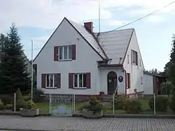
Kněžnice
Kněžnice is a municipality and village in Jičín District in the Hradec Králové Region of the Czech Republic. It has about 300 inhabitants.
Kněžnice | |
|---|---|
 Municipal office | |
 Flag  Coat of arms | |
 Kněžnice Location in the Czech Republic | |
| Coordinates: 50°29′36″N 15°19′21″E | |
| Country | |
| Region | Hradec Králové |
| District | Jičín |
| First mentioned | 1227 |
| Area | |
| • Total | 6.69 km2 (2.58 sq mi) |
| Elevation | 369 m (1,211 ft) |
| Population (2023-01-01)[1] | |
| • Total | 268 |
| • Density | 40/km2 (100/sq mi) |
| Time zone | UTC+1 (CET) |
| • Summer (DST) | UTC+2 (CEST) |
| Postal code | 506 01 |
| Website | www |
Administrative parts
The village of Javornice is an administrative part of Kněžnice.
Geography
Kněžnice is located about 6 km (4 mi) northwest of Jičín and 34 km (21 mi) southeast of Liberec. It lies mostly in the Jičín Uplands. The northern part of the municipal territory extends into the Ještěd–Kozákov Ridge and includes the highest point of Kněžnice, which is located below the top of the Kozlov mountain at 600 m (2,000 ft) above sea level.
The Libuňka Stream originates here and flows across the municipality. The southern part of the territory lies in the Bohemian Paradise Protected Landscape Area.
This article is issued from Wikipedia. The text is licensed under Creative Commons - Attribution - Sharealike. Additional terms may apply for the media files.