Knivskjellodden
Knivskjellodden or Knivskjelodden is a peninsula located in Nordkapp Municipality in Troms og Finnmark county, Norway. It is the northernmost point on the island of Magerøya in Northern Norway. It is sometimes considered the northernmost point of the entire continent of Europe. The nearby Kinnarodden on the Nordkinn Peninsula is the northernmost point on the mainland.[1] The northernmost point of the country Norway is in fact Rossøya, in Svalbard, as far north as 80°N.
Knivskjellodden
Knivskjelodden | |
|---|---|
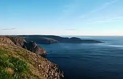 Knivskjellodden as viewed from the North Cape plateau | |
 | |
| Coordinates: 71°11′08″N 25°40′54″E | |
| Location | Troms og Finnmark, Norway |
| Offshore water bodies | Barents Sea |
| Elevation | 0 ft (0 m) |
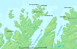
Knivskjellodden can only be reached on foot, after a 9-kilometre (5.6 mi) long hike from a parking area near the European route E69 highway (71.122°N 25.71°E), 6 km (3.7 mi) south of North Cape. The North Cape tourist facility is located on 300 meter altitude and gives good view in good weather, but is often located above the cloud base, giving fog there. On Knivskjellodden hikers can walk to the shore which is at sea level and at least see the ocean, and usually a view far out below the clouds.
Travel agencies that organize trips for unaware tourists often advertise the North Cape (Nordkapp in Norwegian) as the northern extremity of Europe, but this is not true as Knivskjellodden is 1,450 metres (4,760 ft) further north.
Geography
Knivskjellodden is the northernmost point in Europe proper on Magerøya Island in the Barents Sea. The cape is somewhat near Hammerfest, one of the bigger cities in the area,[2] and the northernmost city with more than 10,000 inhabitants. The fishing town of Honningsvag is the closest to this peninsula and the northernmost in Norway. This is the northernmost extension of Lapland (Lappland/Sapmi).[3]
Climate
The climate is treeless tundra (ET),[4] owing to the latitude of 71 degrees north. However, the climate is still very mild for the latitude, closely bordering on both a subpolar oceanic (Cfc) and the rare cool-summer mediterranean (Csc) climate, and shows characteristics that are more typical of oceanic or mediterranean climates than of subarctic or polar ones. For example, the precipitation level peaks in autumn and early winter, and temperature swings from winter to summer are up to ten degrees C more moderated than cities firmly in the temperate zone, such as Seattle, Washington.[5] Winters are long and cold; summers are mild and short. The Barents Sea is largely ice-free in these parts,[6] due to the Gulf stream.
The average high in August is 12 C (53 F), low 9 C (48 F). In February the average high is 0 C (31 F), low -4 C (25 F). Rainfall levels are approximately three times higher in October and December than in June, and snowfall occurs, on average, 19 days a year.[5]
Tourism
This landmark has a monument from the late 20th century.[9] It is rated 4.5 stars out of 5 on TripAdvisor, by 71 reviewers.[10] It is a famous location, due to its situation as the northernmost point of Norway proper (excluding Svalbard or any of the Norwegian islands far removed from the mainland).
People and culture
Peoples
The Sami, indigenous to northern Scandinavia, have inhabited the region for at least three thousand years. They were displaced to the far north, around here and the areas to the south, east, and west of the peninsula when the Finns arrived, around 100 CE. Reindeer herding is a tradition that has been maintained into the 21st century and was the basis of Sami economy until just before then. These people were once nomads.[11]
Vikings and Norse people were predominant at Knivskjellodden and the areas surrounding it from approximately 800 to 1066 CE.[12]
Religion
Most Samis of Sapmi and the areas around it are Russian Orthodox or Lutheran. However, a few Samis still practice shamanism, and some shamanistic practices have been maintained to this day.[11]
See also
- Lindesnes, southernmost point in Norway
- Extreme points of Europe
- Extreme points of Norway
- Troms og Finnmark
- Nordkapp (cape)
- Nordkapp (municipality)
References
- Store norske leksikon. "Knivskjelodden" (in Norwegian). Retrieved 2013-02-13.
- "The journey to the North Cape runs through Western Finnmark". Visit Northern Norway. Retrieved 2023-10-13.
- "Lapland | Location, People, Map, & Facts | Britannica". www.britannica.com. 2023-08-24. Retrieved 2023-10-13.
- gonomadtravel (2007-10-01). "Northernmost Exposure: Norway's Knivskjellodden". www.gonomad.com. Retrieved 2023-10-13.
- "MSN". www.msn.com. Retrieved 2023-10-13.
- "Arctic Sea Ice News and Analysis | Sea ice data updated daily with one-day lag". 2023-10-04. Retrieved 2023-10-13.
- "Arctic Plant life - North Cape Edition". www.visitnorway.com. Retrieved 2023-10-13.
- "Bing". Bing. Retrieved 2023-10-13.
- "Knivskjellodden Tours and Activities".
- "Knivskjellodden - All You Need to Know BEFORE You Go (with Photos)". Tripadvisor. Retrieved 2023-10-13.
- "Sami | People, History, & Lifestyle | Britannica". www.britannica.com. 2023-08-24. Retrieved 2023-10-13.
- "The History of Norwegian Vikings". Fjord Tours. Retrieved 2023-10-13.