Nordkapp
Nordkapp (English: North Cape; Northern Sami: Davvinjárga or Nordkáhppa; Kven: Kappa or Nordkappa) is a municipality in Troms og Finnmark county, Norway. The administrative centre of the municipality is the town of Honningsvåg, where most residents live. Other settlements in Nordkapp include the villages of Gjesvær, Kåfjord, Kamøyvær, Kjelvik, Nordvågen, Repvåg, Skarsvåg, and Valan.[3]
Nordkapp kommune
Davvinjárgga gielda Kappan komuuni | |
|---|---|
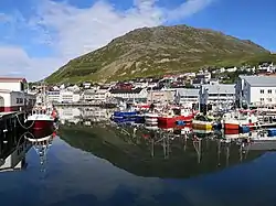 Honningsvåg harbour | |
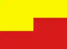 Flag 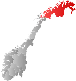 Troms og Finnmark within Norway | |
 Nordkapp within Troms og Finnmark | |
| Coordinates: 70°58′41″N 25°58′29″E | |
| Country | Norway |
| County | Troms og Finnmark |
| District | Vest-Finnmark |
| Established | 1 July 1861 |
| • Preceded by | Kistrand Municipality |
| Administrative centre | Honningsvåg |
| Government | |
| • Mayor (2022) | Trudy Engen (SV) |
| Area | |
| • Total | 925.89 km2 (357.49 sq mi) |
| • Land | 891.56 km2 (344.23 sq mi) |
| • Water | 34.33 km2 (13.25 sq mi) 3.7% |
| • Rank | #127 in Norway |
| Population (2022) | |
| • Total | 2,947 |
| • Rank | #228 in Norway |
| • Density | 3.3/km2 (9/sq mi) |
| • Change (10 years) | |
| Demonym | Nordkappværing[1] |
| Official language | |
| • Norwegian form | Neutral |
| Time zone | UTC+01:00 (CET) |
| • Summer (DST) | UTC+02:00 (CEST) |
| ISO 3166 code | NO-5435 |
| Website | Official website |
The 926-square-kilometre (358 sq mi) municipality is the 127th largest by area out of the 356 municipalities in Norway. Nordkapp is the 228th most populous municipality in Norway with a population of 2,947. The municipality's population density is 3.3 inhabitants per square kilometre (8.5/sq mi) and its population has decreased by 8.7% over the previous 10-year period.[4][5]
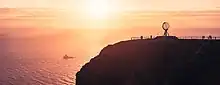
Some 200,000 tourists visit Nordkapp annually during the two to three months of summer. The main tourist attractions are the North Cape and the nearby Knivskjellodden. The North Cape first became famous when the English explorer Richard Chancellor rounded it in 1553 while attempting to find a sea route through the Northeast Passage. Helnes Lighthouse is located at the entrance to the Porsangerfjorden.[3]
General information
On 1 July 1861, the northern district of the municipality of Kistrand was separated to form the new municipality of Kjelvik. Initially, the municipality encompassed the land on both sides of the northern end of the Porsangerfjorden, including the eastern part of the island of Magerøya, and it had a population of 345. The name of the municipality was changed from Kjelvik to Nordkapp in 1950. On 1 January 1984, the western part of the island of Magerøya as well as the small surrounding islands of Gjesværstappan (population: 240) were transferred from Måsøy Municipality to Nordkapp Municipality.[6]
On 1 January 2020, the municipality became part of the newly formed Troms og Finnmark county. Previously, it had been part of the old Finnmark county.[7]
Name
Nordkapp is a Norwegianized form of the English name North Cape by which the area was historically known dating back to at least 1553. The Old Norse name of the cape was Knyskanes. The municipality was originally named Kjelvik, after the main fishing village for the parish. But that village was totally destroyed by the Germans in 1944 and it was never rebuilt. As a consequence of this the municipality changed the name to Nordkapp in 1950.[3]
Coat of arms
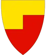
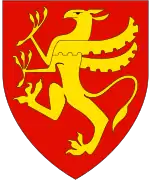
The coat of arms was granted on 19 October 1973. The official blazon is "Per fess angeled Or and gules" (Norwegian: Delt av gull og rødt ved enkelt venstre trappesnitt). This means the arms have a field (background) that is divided by an angeled line. Above the line the field has a tincture of Or which means it is commonly colored yellow, but if it is made out of metal, then gold is used. Below the line, the field has a tincture of gules (red). The arms are designed to look like a simplified silhouette of the North Cape, a large cliff in Nordkapp Municipality that is traditionally taken to be the northernmost point in Norway and of the European continent. The red and yellow colors are meant to show the sea under a golden sky representing the midnight sun. The arms were designed by Hallvard Trætteberg.[8][9][10]
Churches
The Church of Norway has one parish (sokn) within the municipality of Nordkapp. It is part of the Hammerfest prosti (deanery) in the Diocese of Nord-Hålogaland.
| Parish (sokn) | Church name | Location of the church | Year built |
|---|---|---|---|
| Nordkapp | Gjesvær Chapel | Gjesvær | 1960 |
| Honningsvåg Church | Honningsvåg | 1885 | |
| Repvåg Chapel | Repvåg | 1967 | |
| Skarsvåg Church | Skarsvåg | 1961 |
Government
All municipalities in Norway, including Nordkapp, are responsible for primary education (through 10th grade), outpatient health services, senior citizen services, unemployment and other social services, zoning, economic development, and municipal roads. The municipality is governed by a municipal council of elected representatives, which in turn elect a mayor.[11] The municipality falls under the Hammerfest District Court and the Hålogaland Court of Appeal.
Municipal council
The municipal council (Kommunestyre) of Nordkapp is made up of 19 representatives that are elected to four year terms. The party breakdown of the council is as follows:
| Party Name (in Norwegian) | Number of representatives | |
|---|---|---|
| Labour Party (Arbeiderpartiet) | 3 | |
| Conservative Party (Høyre) | 3 | |
| Centre Party (Senterpartiet) | 6 | |
| Socialist Left Party (Sosialistisk Venstreparti) | 7 | |
| Total number of members: | 19 | |
| Party Name (in Norwegian) | Number of representatives | |
|---|---|---|
| Labour Party (Arbeiderpartiet) | 10 | |
| Conservative Party (Høyre) | 4 | |
| Socialist Left Party (Sosialistisk Venstreparti) | 3 | |
| Liberal Party (Venstre) | 2 | |
| Total number of members: | 19 | |
| Party Name (in Norwegian) | Number of representatives | |
|---|---|---|
| Labour Party (Arbeiderpartiet) | 9 | |
| Progress Party (Fremskrittspartiet) | 1 | |
| Conservative Party (Høyre) | 4 | |
| Socialist Left Party (Sosialistisk Venstreparti) | 5 | |
| Total number of members: | 19 | |
| Party Name (in Norwegian) | Number of representatives | |
|---|---|---|
| Labour Party (Arbeiderpartiet) | 8 | |
| Progress Party (Fremskrittspartiet) | 3 | |
| Conservative Party (Høyre) | 3 | |
| Coastal Party (Kystpartiet) | 1 | |
| Centre Party (Senterpartiet) | 2 | |
| Socialist Left Party (Sosialistisk Venstreparti) | 8 | |
| Total number of members: | 25 | |
| Party Name (in Norwegian) | Number of representatives | |
|---|---|---|
| Labour Party (Arbeiderpartiet) | 12 | |
| Conservative Party (Høyre) | 3 | |
| Coastal Party (Kystpartiet) | 3 | |
| Centre Party (Senterpartiet) | 2 | |
| Socialist Left Party (Sosialistisk Venstreparti) | 5 | |
| Total number of members: | 25 | |
| Party Name (in Norwegian) | Number of representatives | |
|---|---|---|
| Labour Party (Arbeiderpartiet) | 11 | |
| Conservative Party (Høyre) | 8 | |
| Centre Party (Senterpartiet) | 1 | |
| Socialist Left Party (Sosialistisk Venstreparti) | 5 | |
| Total number of members: | 25 | |
| Party Name (in Norwegian) | Number of representatives | |
|---|---|---|
| Labour Party (Arbeiderpartiet) | 16 | |
| Conservative Party (Høyre) | 4 | |
| Centre Party (Senterpartiet) | 2 | |
| Socialist Left Party (Sosialistisk Venstreparti) | 3 | |
| Total number of members: | 25 | |
| Party Name (in Norwegian) | Number of representatives | |
|---|---|---|
| Labour Party (Arbeiderpartiet) | 14 | |
| Progress Party (Fremskrittspartiet) | 1 | |
| Conservative Party (Høyre) | 3 | |
| Christian Democratic Party (Kristelig Folkeparti) | 1 | |
| Socialist Left Party (Sosialistisk Venstreparti) | 6 | |
| Nordkapp Independents List (Nordkapp Uavhengige List) | 4 | |
| Total number of members: | 29 | |
| Party Name (in Norwegian) | Number of representatives | |
|---|---|---|
| Labour Party (Arbeiderpartiet) | 16 | |
| Conservative Party (Høyre) | 6 | |
| Christian Democratic Party (Kristelig Folkeparti) | 1 | |
| Socialist Left Party (Sosialistisk Venstreparti) | 6 | |
| Total number of members: | 29 | |
| Party Name (in Norwegian) | Number of representatives | |
|---|---|---|
| Labour Party (Arbeiderpartiet) | 19 | |
| Conservative Party (Høyre) | 6 | |
| Christian Democratic Party (Kristelig Folkeparti) | 1 | |
| Socialist Left Party (Sosialistisk Venstreparti) | 3 | |
| Total number of members: | 29 | |
| Party Name (in Norwegian) | Number of representatives | |
|---|---|---|
| Labour Party (Arbeiderpartiet) | 15 | |
| Conservative Party (Høyre) | 8 | |
| Christian Democratic Party (Kristelig Folkeparti) | 2 | |
| Centre Party (Senterpartiet) | 1 | |
| Socialist Left Party (Sosialistisk Venstreparti) | 3 | |
| Total number of members: | 29 | |
| Party Name (in Norwegian) | Number of representatives | |
|---|---|---|
| Labour Party (Arbeiderpartiet) | 16 | |
| Conservative Party (Høyre) | 5 | |
| Christian Democratic Party (Kristelig Folkeparti) | 2 | |
| Centre Party (Senterpartiet) | 1 | |
| Socialist Left Party (Sosialistisk Venstreparti) | 5 | |
| Total number of members: | 29 | |
| Party Name (in Norwegian) | Number of representatives | |
|---|---|---|
| Labour Party (Arbeiderpartiet) | 18 | |
| Conservative Party (Høyre) | 6 | |
| Christian Democratic Party (Kristelig Folkeparti) | 1 | |
| Socialist common list (Venstresosialistiske felleslister) | 4 | |
| Total number of members: | 29 | |
| Party Name (in Norwegian) | Number of representatives | |
|---|---|---|
| Labour Party (Arbeiderpartiet) | 18 | |
| Conservative Party (Høyre) | 6 | |
| Communist Party (Kommunistiske Parti) | 2 | |
| Christian Democratic Party (Kristelig Folkeparti) | 1 | |
| Socialist People's Party (Sosialistisk Folkeparti) | 2 | |
| Total number of members: | 29 | |
| Party Name (in Norwegian) | Number of representatives | |
|---|---|---|
| Labour Party (Arbeiderpartiet) | 18 | |
| Conservative Party (Høyre) | 6 | |
| Communist Party (Kommunistiske Parti) | 4 | |
| Christian Democratic Party (Kristelig Folkeparti) | 1 | |
| Total number of members: | 29 | |
| Party Name (in Norwegian) | Number of representatives | |
|---|---|---|
| Labour Party (Arbeiderpartiet) | 15 | |
| Conservative Party (Høyre) | 7 | |
| Communist Party (Kommunistiske Parti) | 7 | |
| Total number of members: | 29 | |
| Party Name (in Norwegian) | Number of representatives | |
|---|---|---|
| Labour Party (Arbeiderpartiet) | 14 | |
| Conservative Party (Høyre) | 5 | |
| Communist Party (Kommunistiske Parti) | 9 | |
| Local List(s) (Lokale lister) | 1 | |
| Total number of members: | 29 | |
| Party Name (in Norwegian) | Number of representatives | |
|---|---|---|
| Labour Party (Arbeiderpartiet) | 11 | |
| Communist Party (Kommunistiske Parti) | 10 | |
| Joint List(s) of Non-Socialist Parties (Borgerlige Felleslister) | 7 | |
| Total number of members: | 28 | |
| Party Name (in Norwegian) | Number of representatives | |
|---|---|---|
| Labour Party (Arbeiderpartiet) | 6 | |
| Communist Party (Kommunistiske Parti) | 11 | |
| Local List(s) (Lokale lister) | 3 | |
| Total number of members: | 20 | |
| Party Name (in Norwegian) | Number of representatives | |
|---|---|---|
| Labour Party (Arbeiderpartiet) | 9 | |
| Communist Party (Kommunistiske Parti) | 6 | |
| Local List(s) (Lokale lister) | 7 | |
| Total number of members: | 20 | |
| Note: Due to the German occupation of Norway during World War II, no elections were held for new municipal councils until after the war ended in 1945. | ||
Geography
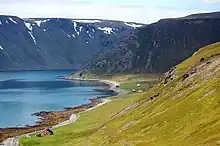
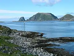
The municipality encompasses the island of Magerøya, but also parts of the mainland on the Porsanger Peninsula and Sværholt Peninsula on both sides of the Porsangerfjorden. There are many other fjords in the municipality including Duksfjorden, Kåfjorden, Kamøyfjorden, and Skipsfjorden. The main island is Magerøya and there are a few islands located around Magerøya including Gjesvær, Gjesværstappan, Lille Kamøya, and Store Kamøya.[3]
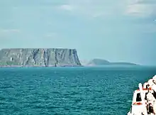
North Cape
The municipality is named after Nordkapp (North Cape), a 307-metre-high (1,007 ft) cliff that is commonly referred to as the northernmost point of Europe. However, the true northernmost point of the European mainland is Cape Nordkinn (Kinnarodden), at 71° 08′ 02″ N, located about 20 kilometres (12 mi) from the village of Mehamn on the Nordkinn Peninsula. If Europe's northernmost point is allowed to be on an island, then it still is not the North Cape. It would be Cape Fligely on Rudolf Island, Franz Josef Land in Russia, which is located much further north at 81° 48′ 24″ N. If Franz Josef Land is not considered to be in Europe, then Europe's northernmost point is the northern point of the island of Rossøya, an islet in Svalbard, north of Spitsbergen at 80° 49′ 44.41″ N.
Birdlife
.jpeg.webp)
This coastal municipality is like many others in Finnmark, home of large seabird colonies. The island group known as Gjesværstappan is one of the better known with at least 2,500 pairs of razorbill. Away from the coast it is the typical tundra habitat of the region that dominates with lakes, marshes, and areas of willow scrub. Many of the lakes hold breeding wildfowl, with species like long-tailed duck being found.
Climate
The populated areas of Nordkapp municipality have a subarctic climate (Dfc) with long, moderately cold winters and short, cool summers. If February were slightly warmer it would be a subpolar oceanic climate (Cfc). The well known North Cape plateau (cliff) is at 307 m ASL and will be colder with a tundra climate.
| Climate data for Nordkapp[lower-alpha 1], 1991–2020 normals, extremes 2002–present | |||||||||||||
|---|---|---|---|---|---|---|---|---|---|---|---|---|---|
| Month | Jan | Feb | Mar | Apr | May | Jun | Jul | Aug | Sep | Oct | Nov | Dec | Year |
| Record high °C (°F) | 6.8 (44.2) |
7.8 (46.0) |
8.3 (46.9) |
12.5 (54.5) |
20.1 (68.2) |
28.4 (83.1) |
27.1 (80.8) |
24.8 (76.6) |
18.9 (66.0) |
13.3 (55.9) |
9.2 (48.6) |
8.6 (47.5) |
28.4 (83.1) |
| Mean maximum °C (°F) | 4.9 (40.8) |
4.9 (40.8) |
4.9 (40.8) |
7.8 (46.0) |
13.7 (56.7) |
17.7 (63.9) |
22.6 (72.7) |
20.2 (68.4) |
15.7 (60.3) |
10.5 (50.9) |
7.1 (44.8) |
6.2 (43.2) |
22.9 (73.2) |
| Average high °C (°F) | −0.5 (31.1) |
−1.0 (30.2) |
0.4 (32.7) |
3.0 (37.4) |
6.8 (44.2) |
9.6 (49.3) |
13.4 (56.1) |
12.7 (54.9) |
10.2 (50.4) |
5.6 (42.1) |
2.8 (37.0) |
1.4 (34.5) |
5.4 (41.7) |
| Daily mean °C (°F) | −2.5 (27.5) |
−3.3 (26.1) |
−1.7 (28.9) |
0.7 (33.3) |
4.2 (39.6) |
6.9 (44.4) |
10.2 (50.4) |
10.2 (50.4) |
8.0 (46.4) |
3.8 (38.8) |
0.7 (33.3) |
−0.8 (30.6) |
3.0 (37.4) |
| Average low °C (°F) | −4.8 (23.4) |
−5.2 (22.6) |
−3.4 (25.9) |
−0.9 (30.4) |
2.6 (36.7) |
5.5 (41.9) |
8.6 (47.5) |
8.6 (47.5) |
6.5 (43.7) |
2.3 (36.1) |
−0.9 (30.4) |
−2.7 (27.1) |
1.3 (34.3) |
| Mean minimum °C (°F) | −10.7 (12.7) |
−10.6 (12.9) |
−8.5 (16.7) |
−6.0 (21.2) |
−1.5 (29.3) |
1.5 (34.7) |
5.3 (41.5) |
5.0 (41.0) |
2.6 (36.7) |
−2.8 (27.0) |
−5.6 (21.9) |
−8.3 (17.1) |
−12.5 (9.5) |
| Record low °C (°F) | −15.3 (4.5) |
−17.2 (1.0) |
−11.0 (12.2) |
−10.0 (14.0) |
−5.7 (21.7) |
0.0 (32.0) |
0.0 (32.0) |
1.0 (33.8) |
0.0 (32.0) |
−5.6 (21.9) |
−11.3 (11.7) |
−21.2 (−6.2) |
−21.2 (−6.2) |
| Average precipitation mm (inches) | 55 (2.2) |
39 (1.5) |
51 (2.0) |
36 (1.4) |
42 (1.7) |
46 (1.8) |
48 (1.9) |
52 (2.0) |
64 (2.5) |
78 (3.1) |
50 (2.0) |
63 (2.5) |
627 (24.7) |
| Average extreme snow depth cm (inches) | 61 (24) |
60 (24) |
59 (23) |
64 (25) |
32 (13) |
0 (0) |
0 (0) |
0 (0) |
1 (0.4) |
31 (12) |
31 (12) |
32 (13) |
75 (30) |
| Average precipitation days (≥ 1.0 mm) | 9 | 7 | 10 | 8 | 7 | 7 | 7 | 6 | 7 | 10 | 7 | 8 | 94 |
| Average relative humidity (%) | 78 | 78 | 76 | 75 | 72 | 77 | 79 | 79 | 78 | 79 | 79 | 78 | 77 |
| Average dew point °C (°F) | −6.0 (21.2) |
−6.6 (20.1) |
−5.4 (22.3) |
−2.9 (26.8) |
0.2 (32.4) |
3.5 (38.3) |
7.1 (44.8) |
6.8 (44.2) |
4.9 (40.8) |
0.7 (33.3) |
−2.2 (28.0) |
−3.9 (25.0) |
−0.3 (31.5) |
| Source 1: Norwegian Meteorological Institute[29][30][31] | |||||||||||||
| Source 2: yr.no /Norwegian Meteorological Institute[32] | |||||||||||||
| Climate data for Helnes Lighthouse 1961-90 | |||||||||||||
|---|---|---|---|---|---|---|---|---|---|---|---|---|---|
| Month | Jan | Feb | Mar | Apr | May | Jun | Jul | Aug | Sep | Oct | Nov | Dec | Year |
| Average high °C (°F) | −1.5 (29.3) |
−1.6 (29.1) |
−0.7 (30.7) |
1.4 (34.5) |
5.2 (41.4) |
9.3 (48.7) |
12.6 (54.7) |
11.8 (53.2) |
8.6 (47.5) |
4.5 (40.1) |
1.5 (34.7) |
−0.5 (31.1) |
4.2 (39.6) |
| Daily mean °C (°F) | −3.6 (25.5) |
−3.6 (25.5) |
−2.4 (27.7) |
−0.2 (31.6) |
3.4 (38.1) |
6.9 (44.4) |
10.1 (50.2) |
9.7 (49.5) |
6.9 (44.4) |
3.0 (37.4) |
−0.2 (31.6) |
−2.4 (27.7) |
2.3 (36.1) |
| Average low °C (°F) | −5.7 (21.7) |
−5.7 (21.7) |
−4.2 (24.4) |
−1.8 (28.8) |
1.6 (34.9) |
5.0 (41.0) |
8.0 (46.4) |
8.0 (46.4) |
5.4 (41.7) |
1.5 (34.7) |
−2.0 (28.4) |
−4.3 (24.3) |
0.5 (32.9) |
| Average precipitation mm (inches) | 94 (3.7) |
75 (3.0) |
67 (2.6) |
59 (2.3) |
42 (1.7) |
40 (1.6) |
44 (1.7) |
50 (2.0) |
59 (2.3) |
83 (3.3) |
82 (3.2) |
101 (4.0) |
796 (31.3) |
| Average precipitation days (≥ 1 mm) | 18.1 | 15.3 | 14.6 | 13.6 | 10.6 | 9.6 | 9.3 | 10.5 | 13.9 | 17.5 | 16.5 | 18.7 | 168.2 |
| Source: yr.no/Norwegian Meteorological Institute[33] | |||||||||||||
Note
- Temperature, humidity and dew point from Honningsvåg Airport (14m), precipitation and extreme snow depth from Repvåg.
Transportation
Due to the heavy tourist traffic in the summers, Nordkapp has an extensive transportation infrastructure for such a small, remote municipality. The Honningsvåg Airport is located just north of the town of Honningsvåg, with daily connections to Tromsø. The European route E69 highway runs north throughout the municipality from Porsanger to the North Cape. The North Cape Tunnel connects the mainland to the island of Magerøya. The Honningsvåg Tunnel goes through a large mountain near Honningsvåg.[3]
Notable people
.jpg.webp)
- Thor With (1918 in Honningsvåg - 1987) a theologian and Bishop of the Diocese of Bjørgvin
- Terje Stigen (1922 on Magerøya – 2010) a Norwegian author
- Idar Kristiansen (1932 in Honningsvåg – 1985) a poet, novelist and short story writer
- Gunnar Stålsett (born 1935 in Nordkapp) a theologican and politician; leader of the Centre Party & Bishop of Oslo
- Knut Erik Jensen (born 1940 in Honningsvåg) a Norwegian film director [34]
- Ingunn Utsi (born 1948 in Repvågstranda) a Sami sculptor, painter and book illustrator
- John Arne Markussen (born 1953 in Repvåg) a Norwegian journalist and newspaper editor
- Guri Berg (born 1963) a Norwegian artist and sculptor, grew up in Honningsvåg
- Ingeborg Arvola (born 1974 in Honningsvåg) a Norwegian novelist and children's writer
- William Frantzen (born 1993) a Norwegian retired footballer, grew up in Honningsvåg
References
- "Navn på steder og personer: Innbyggjarnamn" (in Norwegian). Språkrådet.
- "Forskrift om målvedtak i kommunar og fylkeskommunar" (in Norwegian). Lovdata.no.
- Store norske leksikon. "Nordkapp kommune" (in Norwegian). Retrieved 18 February 2013.
- Statistisk sentralbyrå. "Table: 06913: Population 1 January and population changes during the calendar year (M)" (in Norwegian).
- Statistisk sentralbyrå. "09280: Area of land and fresh water (km²) (M)" (in Norwegian).
- Jukvam, Dag (1999). "Historisk oversikt over endringer i kommune- og fylkesinndelingen" (PDF) (in Norwegian). Statistisk sentralbyrå.
- Mæhlum, Lars, ed. (24 December 2019). "Troms og Finnmark". Store norske leksikon (in Norwegian). Kunnskapsforlaget. Retrieved 26 December 2019.
- "Civic heraldry of Norway - Norske Kommunevåpen". Heraldry of the World. Retrieved 23 January 2023.
- "Nordkapp, Finmark (Norway)". Flags of the World. Retrieved 23 January 2023.
- "Godkjenning av våpen og flagg". Lovdata.no (in Norwegian). Norges kommunal- og arbeidsdepartementet. 19 October 1973. Retrieved 23 January 2023.
- Hansen, Tore, ed. (12 May 2016). "kommunestyre". Store norske leksikon (in Norwegian). Kunnskapsforlaget. Retrieved 5 June 2018.
- "Tall for Norge: Kommunestyrevalg 2019 - Troms og Finnmark". Valg Direktoratet. Retrieved 23 October 2019.
- "Table: 04813: Members of the local councils, by party/electoral list at the Municipal Council election (M)" (in Norwegian). Statistics Norway.
- "Tall for Norge: Kommunestyrevalg 2011 - Finnmark". Valg Direktoratet. Retrieved 23 October 2019.
- "Kommunestyrevalget 1995" (PDF) (in Norwegian). Oslo-Kongsvinger: Statistisk sentralbyrå. 1996. Retrieved 17 March 2020.
- "Kommunestyrevalget 1991" (PDF) (in Norwegian). Oslo-Kongsvinger: Statistisk sentralbyrå. 1993. Retrieved 17 March 2020.
- "Kommunestyrevalget 1987" (PDF) (in Norwegian). Oslo-Kongsvinger: Statistisk sentralbyrå. 1988. Retrieved 17 March 2020.
- "Kommunestyrevalget 1983" (PDF) (in Norwegian). Oslo-Kongsvinger: Statistisk sentralbyrå. 1984. Retrieved 17 March 2020.
- "Kommunestyrevalget 1979" (PDF) (in Norwegian). Oslo: Statistisk sentralbyrå. 1979. Retrieved 17 March 2020.
- "Kommunevalgene 1975" (PDF) (in Norwegian). Oslo: Statistisk sentralbyrå. 1977. Retrieved 17 March 2020.
- "Kommunevalgene 1972" (PDF) (in Norwegian). Oslo: Statistisk sentralbyrå. 1973. Retrieved 17 March 2020.
- "Kommunevalgene 1967" (PDF) (in Norwegian). Oslo: Statistisk sentralbyrå. 1967. Retrieved 17 March 2020.
- "Kommunevalgene 1963" (PDF) (in Norwegian). Oslo: Statistisk sentralbyrå. 1964. Retrieved 16 March 2020.
- "Kommunevalgene og Ordførervalgene 1959" (PDF) (in Norwegian). Oslo: Statistisk sentralbyrå. 1960. Retrieved 17 March 2020.
- "Kommunevalgene og Ordførervalgene 1955" (PDF) (in Norwegian). Oslo: Statistisk sentralbyrå. 1957. Retrieved 17 March 2020.
- "Kommunevalgene og Ordførervalgene 1951" (PDF) (in Norwegian). Oslo: Statistisk sentralbyrå. 1952. Retrieved 17 March 2020.
- "Kommunevalgene og Ordførervalgene 1945" (PDF) (in Norwegian). Oslo: Statistisk sentralbyrå. 1947. Retrieved 17 March 2020.
- "Kommunevalgene og Ordførervalgene 1937" (PDF) (in Norwegian). Oslo: Statistisk sentralbyrå. 1938. Retrieved 17 March 2020.
- "Observations and weather statistics (SN94680 HONNINGSVÅG LUFTHAVN / SN94800 REPVÅG)". Norwegian Meteorological Institute. Retrieved 21 September 2023.
- "Temperaturnormaler per måned og år (Temperature norms per month and year)" (in Norwegian). Norwegian Meteorological Institute. Archived from the original on 9 October 2023. Retrieved 9 October 2023.
- "Nedbørnormaler per måned og år (Precipitation per month and year)" (in Norwegian). Norwegian Meteorological Institute. Archived from the original on 12 October 2023. Retrieved 12 October 2023.
- "yr.no Honningsvåg statistics". Norwegian Meteorological Institute.
- "yr.no/met.no". Norwegian Meteorological Institute.
- IMDb Database retrieved 26 September 2020
External links
- Municipal fact sheet from Statistics Norway (in Norwegian)
- Pictures from North Cape and Skarsvåg
- Motorbike travel from Italy to Nordkapp
- From Nordkapp to Italy by bike
- Nordkapp by rail
- 360x180° Panoramen from Nordkapp
- 6-day road trip from The Netherlands to the Nordkapp
Troms og Finnmark county, Norway | |||||||||
|---|---|---|---|---|---|---|---|---|---|
| |||||||||
 | Towns and cities |
|   | ||||||
| Municipalities |
| ||||||||