Konaseema district
Konaseema district (officially known as Dr B. R. Ambedkar Konaseema district) is one of the 26 districts in the Indian state of Andhra Pradesh. It is situated between the tributaries of the Godavari river in the Konaseema region of Coastal Andhra. It was carved out of East Godavari district on 4 April 2022 by the Government of Andhra Pradesh. Amalapuram is the district headquarters and the largest city in this district. Other significant towns in the district are Mandapeta, Ramachandrapuram, and Mummidivaram.
Konaseema district | |
|---|---|
| Dr. B. R. Ambedkar Konaseema district | |
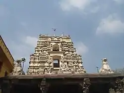 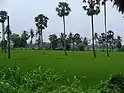 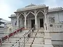   Clockwise from top-left: Bhimeswara temple at Draksharama, Crop fields in Yeditha, Street of Amalapuram, Antarvedi Beach, Gummileru Jain Temple | |
.svg.png.webp) | |
| Coordinates: 16.6°N 82.0°E | |
| Country | |
| State | |
| Region | Coastal Andhra |
| Formed | 4 April 2022 |
| Founded by | Government of Andhra Pradesh |
| Named for | Dr.B. R. Ambedkar |
| Headquarters | Amalapuram |
| Government | |
| • District collector | Sri Himanshu Shukla IAS Collector & District Magistrate |
| • Lok Sabha constituencies | Amalapuram |
| • MP | Chinta Anuradha |
| • Assembly constituencies | 07 |
| Area | |
| • Total | 2,081.2 km2 (803.6 sq mi) |
| Population (2011)[1] | |
| • Total | 1,719,093 |
| • Density | 830/km2 (2,100/sq mi) |
| Languages | |
| • Official | Telugu |
| Time zone | UTC+05:30 (IST) |
| Website | konaseema |
Geography
Konaseema is located in the delta of the Godavari river. The economy is based mainly on agriculture, primarily rice production. There are some Mangrove forests in the northeast of the district.[2] It lies in between the two branches of the Godavari river. The Godavari divides into two components (i.e. Gautami and Vasishtha) and forms an island previously called Nagaram during the Mughal era. The land here is considered very fertile and suitable for agriculture.[3]
This district is surrounded to the north by East Godavari district, south by the Bay of Bengal, east by Kakinada district and west by West Godavari district.[4]
Politics
There are one parliamentary and seven assembly constituencies in the Konaseema district. The parliamentary constituency is Amalapuram (Lok Sabha constituency). The assembly constituencies are listed below[5]
| Constituency number | Name | Reserved for (SC/ST/None) |
Parliament |
|---|---|---|---|
| 42 | Ramachandrapuram | None | Amalapuram |
| 43 | Mummidivaram | None | |
| 44 | Amalapuram | SC | |
| 45 | Razole | SC | |
| 46 | Gannavaram | SC | |
| 47 | Kothapeta | None | |
| 48 | Mandapeta | None |
Administrative divisions
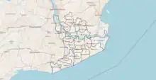
The district is divided into 3 revenue divisions: Amalapuram, Kothapeta and Ramachandrapuram, which are further subdivided into a total of 22 mandals, each headed by a sub-collector.[6]
Mandals
The list of 22 mandals in Dr B. R. Ambedkar Konaseema district,[7] divided into 3 revenue divisions, is given below.[8]
Cities and towns
| Rank | Division | Pop. | |||||||
|---|---|---|---|---|---|---|---|---|---|
| 1 | Mandapeta | Ramachandrapuram Division | 65,406 | ||||||
| 2 | Amalapuram | Amalapuram Division | 53,231 | ||||||
| 3 | Ramachandrapuram | Ramachandrapuram Division | 43,657 | ||||||
| 4 | Mummidivaram | Amalapuram Division | 25,355 | ||||||
| 5 | [[{{{city_5}}}]] | [[{{{div_5}}}]] | {{{pop_5}}} | ||||||
| 6 | [[{{{city_6}}}]] | [[{{{div_6}}}]] | {{{pop_6}}} | ||||||
| 7 | [[{{{city_7}}}]] | [[{{{div_7}}}]] | {{{pop_7}}} | ||||||
| 8 | [[{{{city_8}}}]] | [[{{{div_8}}}]] | {{{pop_8}}} | ||||||
| 9 | [[{{{city_9}}}]] | [[{{{div_9}}}]] | {{{pop_9}}} | ||||||
| 10 | [[{{{city_10}}}]] | [[{{{div_10}}}]] | {{{pop_10}}} | ||||||
| S.No. | City / Town | Municipality
formation year |
No. of
Wards |
Civic status
of municipal body |
2011 census
population |
2001 census
population |
1991 census
population |
1981 census
population |
1971 census
population |
1961 census
population |
1951 census
population |
|---|---|---|---|---|---|---|---|---|---|---|---|
| 1 | Mandapeta | 1958 | 30 | Municipality Grade - 2 | 65,406 | 51,638 | 42,453 | 33,499 | 25,316 | 19,766 | 15,139 |
| 2 | Amalapuram | 1948 | 30 | Municipality Grade - 1 | 53,231 | 51,444 | 46,029 | 38,999 | 30,518 | 24,063 | 21,117 |
| 3 | Ramachandrapuram | 1959 | 28 | Municipality Grade - 2 | 43,657 | 41,370 | 36,788 | 30,902 | 23,685 | 18,778 | 15,381 |
| 4 | Mummidivaram | 2011 | 20 | Nagar Panchayat | 25,355 | -- | -- | -- | -- | -- | -- |
| S.No. | Town | Civic Status of Town | 2011 Census
Population |
|---|---|---|---|
| 1 | Tallarevu | Grama panchayat | 24,550 |
| 2 | Kothapeta | Grama panchayat | 24,539 |
| 3 | Rayavaram | Grama panchayat | 17,361 |
| 4 | Razole | Grama panchayat | 13,597 |
| 5 | Alamur | Grama panchayat | 9,723 |
| 6 | P.Gannavaram | Grama panchayat | 9,459 |
| 7 | Korukonda | Grama panchayat | 9,228 |
| 8 | Rangampeta | Grama panchayat | 7,983 |
| S.No. | Town | Civic status of town | 2011 census
population |
|---|---|---|---|
| 1 | Bandaru Lanka [Amalapuram] | Census town | 11,470 |
| 2 | Arempudi [Sankhavaram] | Census town | 5,073 |
Demographics
At the time of the 2011 census, Konaseema district had a population of 1,719,093, of which 164,421 (9.56%) lived in urban areas. Konaseema district had a sex ratio of 994 females per 1000 males.[10]: 85–90 Scheduled Castes and Scheduled Tribes comprised 427,130 (24.85%) and 13,481 (0.78%).[1]
Telugu is the predominant language, spoken by 99.41% of the population.[11]
Culture
The region has a diverse folk culture. In the heart of the Godavari Delta, Konaseema is one of the only two regions in India, apart from Kerala, where a large community still practices traditional Shrauta rituals. These traditions have largely fallen out of use in the rest of India, making it a favoured destination for scholars seeking to understand ancient Vedic culture.[12]
The villagers also have a varied folk culture with their regional gods. Most of the Dalits, like in most of Coastal Andhra, are Christians - both Catholic and Protestant.[13]
Transportation
National Highway NH216 connects Konaseema District. Andhra Pradesh public state transport operates APSRTC bus services from the district headquarters Amalapuram to Rajahmundry, Razole, Kakinada, Annavaram, Visakhapatnam, Ravulapalem, Tanuku, Eluru, Palakollu, Tuni, Hyderabad, Vijayawada, Srikakulam, Tekkali, Ichapuram, Vizianagaram, Narsapuram, Bhimavaram, Machilipatnam, Srisailam, Guntur and Tirupati.
Nearest railway stations
Rajahmundry railway station, Palakollu railway station, Narsapuram railway station, Bhimavaram Junction railway station, and Bhimavaram Town Halt railway station are the nearest railway stations.[14]
Proposed railway line
The Kakinada - Kotipalli - Narsapur railway line is under construction, and a bridge over the Godavari river is being constructed.[15] Once operational, this railway will also make a stop at Amalapuram.[16][17]
See also
References
- "Demography | Dr. B. R. Ambedkar Konaseema District | India".
- "Konaseema | PDF | Agriculture | Nature". Scribd. Retrieved 6 June 2022.
- Charles Alfred Browne (1843). Alfred Radford Symonds (ed.). "An Introduction to the Geography and History of India, and the Countries Adjacent". P.R. Hunt. p. 188.
- "Map of the Konaseema district". 6 February 2023.
- "District-wise Assembly-Constituencies". ceoandhra.nic.in.
- "MANDALS | Dr. B. R. Ambedkar Konaseema District | India". Retrieved 7 April 2022.
- "G.O. on naming Konaseema district after Dr. B.R. Ambedkar issued". The Hindu. 3 August 2022. ISSN 0971-751X. Retrieved 13 September 2022.
- "AP cabinet approves two new revenue divisions". Deccan Chronicle. 7 April 2022. Retrieved 1 May 2022.
- "Population by Religion - Andhra Pradesh". censusindia.gov.in. Registrar General and Census Commissioner of India. 2011.
- "District Census Hand Book – East Godavari" (PDF). Census of India. Registrar General and Census Commissioner of India.
- "Table C-16 Population by Mother Tongue: Andhra Pradesh". Census of India. Registrar General and Census Commissioner of India.
- Knipe, David M. (1 April 2015). Vedic Voices: Intimate Narratives of a Living Andhra Tradition. Oxford University Press. doi:10.1093/acprof:oso/9780199397686.001.0001. ISBN 978-0-19-939768-6.
- "When the Caregiver Is Also a Survivor", Touched, 1517 Media, pp. 76–92, 3 March 2020, doi:10.2307/j.ctvp7d5f8.10, S2CID 240764530, retrieved 6 June 2022
- "Nearest Railway Stations to Konaseema Andhra Pradesh East Godavari". trainspy.com. Retrieved 7 June 2022.
- "Kotipalli-Narasapur railway line project work in Andhra Pradesh on track". The New Indian Express. Retrieved 13 April 2022.
- Naidu, T. Appala (13 February 2022). "'Release State share to complete Kotipalli-Narsapur railway project', demands BJP MP GVL". The Hindu. ISSN 0971-751X. Retrieved 13 April 2022.
- "త్వరలోనే కోనసీమకు రైలు కూత". Sakshi (in Telugu). 27 February 2016. Retrieved 13 April 2022.
External links
| Topics | |||
|---|---|---|---|
| Regions | |||
| Districts | |||
| Million-plus cities | |||
| Cities (population over 1 lakh) |
| ||
| Tourism |
| ||
| History | |||
| Related lists | |||